The autumnal blip this weekend will continue with some showery weather into the start of next week. But then high pressure will start to build again from the south.
It's turning out to be quite a blip in our summer this weekend. Starting with some severe thunderstorms Friday evening, we then saw a drop of 10-15c in some parts of the country by Saturday, coupled with some strong winds and heavy showers. Now today, it's windier still, with bands of rain crossing the country, brought by a pair of unseasonably deep low pressures. But, high pressure will be back next week, settling and warming the weather up again.
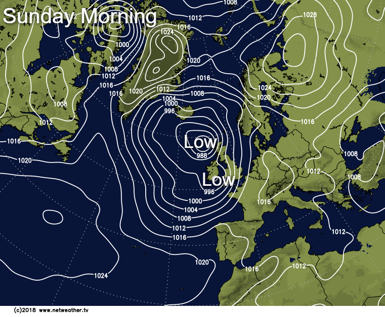
For now though, just about all of England and Wales has started wet today, with only parts of Northern Scotland mostly dry initially, but even here it won't be staying that way as the rain moves up from the southwest. It's all being pushed through on the strong south to southwest winds, which'll touch gale force in exposed spots.
The rain will become more patchy and showery from the south during the day, with the persistent wet weather taking until after dark to clear away from the far north of Scotland. Following behind will be some blustery showers, these particularly affecting southern and western parts overnight. They'll become more widespread into Monday though, with some becoming thundery. Not all will catch them though, and there'll be some sunshine breaking through in between them.
Temperatures in the southeast corner will reach a warm, 24-26c during the sunny spells into the afternoon, elsewhere 19-22c will be more typical, so warmer than we've seen over the weekend.
Into Tuesday, with high pressure starting to build in from the south, the showers will become more limited to the northwest of the country. Elsewhere, the odd one can't be ruled out, but in the main, it's dry with sunny spells developing. Temperatures will typically range from 19-23c.
Wednesday follows on with a similar day, and much the same can be said about Thursday too. With high pressure now back on top of things across the southern half of the country, it'll be dry and mostly sunny here, but further northwest, there'll still be some rain to contend with. It'll become increasingly warmer from the south too, with highs edging back into the mid-high twenties by this point.
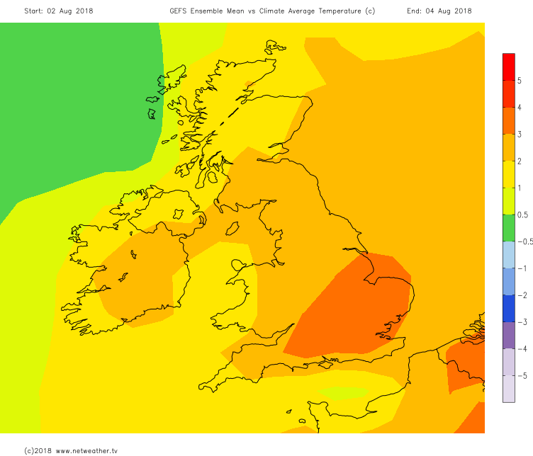 The latter part of the week, and into next weekend is then likely to see the high pressure growing its influence far enough north to settle even the far northwest down for a good part of the time at least. The warmest temperatures are still likely to be in southern and central regions, but all parts should be seeing temperatures above the norm for the time of the year again, as this weekend becomes a distant memory.