After a hot end to the week, hints of cooler conditions returning to the north from Sunday, staying very warm or hot in the south with risk of thundery showers.
Porthmadog in NW Wales has reached 31.9C this afternoon, making it the hottest day of the year so far, topping 30.7C reached at Rostherne in Cheshire yesterday which, until this afternoon, was the highest temperature of the year so far.
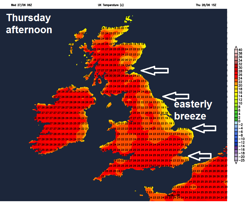
An easterly breeze will continue to blow for the rest of the week towards the east, as high pressure repositions across northern UK, which means that the highest temperatures continue to be towards the north and west of Britain. We could see temperatures reaching the low 30s Celsius across northern England, N. Ireland and Scotland on Thursday and Friday - where winds will be lighter or sheltered from the easterly breeze, which may mean the June record for Northern Ireland of 30.8C and Scotland’s June record of 32.2C could be threatened.
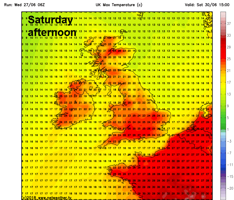
The very warm weather looks to continue over the weekend, though not quite so hot as this week, with highs of mid-to-high twenties in the warmer spots, hottest temperatures tending to be towards the south, while cooling off in the north.
Cooling off in the north this weekend, the south, especially SE, staying very warm or hot
Although the heat will ease in the north this weekend and into next week, southern areas will continue very warm or locally hot well into next week. Those who would like some rain for the garden, there has been hints of a rain for some later this weekend and into early next week, as low pressure and fronts to the southwest edge in, though it will be a slow process starting in the far southwest and not everywhere will see rain.
The models have not been particularly reliable in the medium range recently with regards to the eventual movement of the current blocking high bringing our fine and hot weather and subsequently the handling the Atlantic trough disruption and diverting jet stream hitting up against the block to the west.
Upper low off Iberia merges with upper trough moving east out of NW Atlantic next week and pushes toward UK, as blocking high retreats
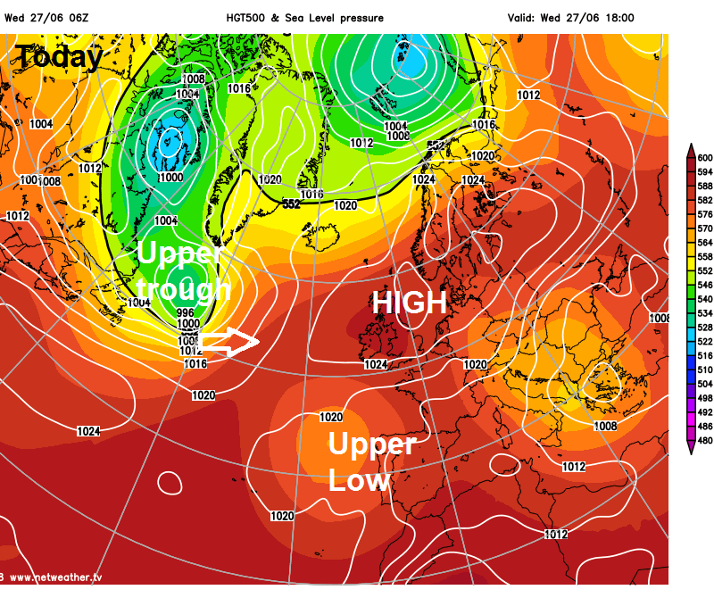
There is a cut-off low between the Azores and Iberia and the models have been chopping and changing over whether to phase it (or not) with broadscale troughing further north over the N Atlantic, so this has been causing some medium range uncertainty.
For a while the models have been inclined to keep the closed low off Iberia away from the upper westerlies further north, which has maintained blocking over / near the UK. But there was a sudden change yesterday from previous runs in the days before towards models converging on the idea of pulling the upper low off Iberia northeastward toward the Bay of Biscay and phasing it with upper troughing digging down from the NW Atlantic next weekend. This in turn leads to a breakdown of the heatwave from the SW, though details of how this occurs and when remains elusive for now.
The model output this morning seem to be delaying the onset of the breakdown from the southwest this morning compared to yesterday’s model guidance and some models (ECMWF and UKMO) bringing very little if any rain across the UK until later next week, which is going to a less reliable timeframe for confidence of it coming off.
The models often have issues with handling Atlantic trough disruption against departing blocking anticyclones such as is over the UK this week. So there are often big swings in evolution to how quickly it wants to remove a blocking high and subsequently breakdown settled conditions. Yesterday the models were hinting at the weekend for the start of the breakdown, this morning it is delayed into next week.
GFS model is currently hinting at some thundery rain spreading in across the south from Sunday into early next week. However, some other models keep the south mainly dry.
00z and 06z GFS brings some thundery rain across the SW of Britain and southern Ireland late Saturday into Sunday, thundery showers then perhaps spreading into southern parts of England and Wales further east by Sunday evening and continuing through Monday and into Tuesday. Whilst 00z ECMWF shows most of the UK dry this weekend, bar some rain clipping northern Scotland as an Atlantic front brushes here, with showers barely clipping Cornwall early on Monday morning, whilst Monday and Tuesday remain dry for most areas. It looks to cool down early next week across the north and west, where temperatures may more typically reach the low 20s Celsius rather than mid-to-high twenties. But towards central, eastern and southeasten England it will remain very warm or locally hot and increasingly humid. Thundery downpours may become more widespread across southern and eastern parts of England mid-week, but from there uncertainty increases thanks to differences appearing between models.
Cooler air from the west off the NW Atlantic flooding in across northern areas later next week?
There does appear to be some broadscale model agreement, for now, on the upper trough to the west and southwest eventually moving through and introducing a cooler and fresher westerly flow off the Atlantic later next week, probably behind a cold front which will bring some rain to the north and west. However, given recent chopping and changing plus delaying from the models on any breakdown, confidence is not too high for now.