
Rain for England & Wales today, mixed over the weekend and on the cool side, persistent rain for the SE late on Sunday.

Friday will see a bit of a north-south split across the UK, the north will be cool and bright but with showers, the south cloudy, wet and windy for much of the day. Saturday will stay cloudy, damp and cool across southern and eastern England, brighter elsewhere – with sunny spells and a few showers. Bright, with the odd shower on Sunday, before wet and increasingly windy weather moves in across SE England later in the day. Rain, locally heavy, persisting through Monday across SE England and E Anglia, feeling cold here in a strong northeasterly wind, drier and brighter elsewhere.
For now, a chilly start across Scotland, N. Ireland and northern England – clear skies overnight have allowed the temperature to fall below freezing across Northern Ireland. Although for many here it’s a sunny start, there are some heavy showers affecting northern Scotland. Further south, a different story, with cloud and outbreaks of rain affecting Wales, the Midlands, southern England across to East Anglia – the rain locally heavy and persistent across southern counties – which will bring some tricky conditions on the roads for the morning commute.
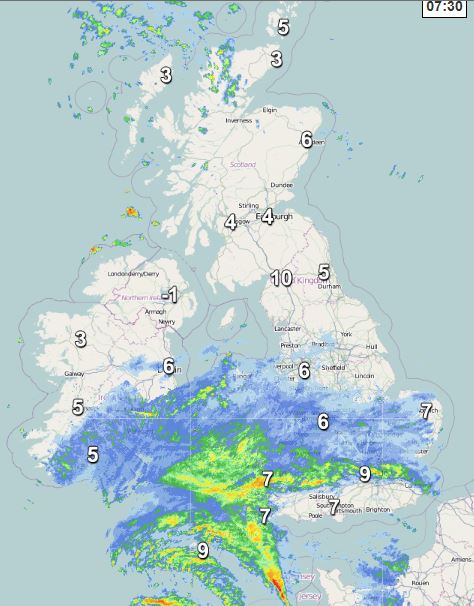
The rain will become more extensive across England and Wales through the day, heavy in places, spreading north across northern England too. Perhaps some drier and brighter conditions moving in across southern England and later across Wales, which will lift the temperatures to around 14-15C, but with it, a risk of heavy showers developing across southern counties. Under the cloud and rain, reaching 8-10C at best.
Across Scotland and Northern Ireland, staying bright or sunny, but with some heavy showers affecting northern Scotland and the northern side of Northern Ireland, in the sunshine reaching 12-13C, but feeling cooler under any showers.
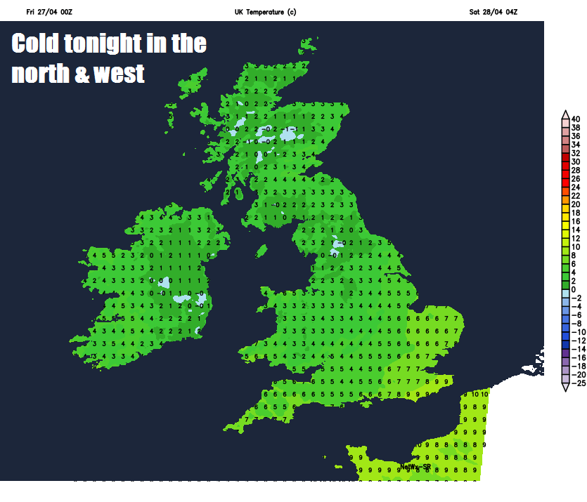
Outbreaks of rain, locally heavy, lingering for this evening’s commute across southern, central and eastern England, but clearing western areas. The rain persisting across parts of southern England and East Anglia overnight too. Elsewhere, showers dying away in the far north, to leave most to a dry night with clear spells and mist patches forming, turning chilly too, with a patchy ground frost developing in the north and west.
Not anything like as warm as last weekend, a generally cloudy and cool day likely on Saturday for much of England and Wales, still some patchy outbreaks of rain hanging on for a time across SE England, the Midlands and East Anglia, perhaps some brighter weather but with a few showers across west Wales, northern and far SW of England. Scotland and Northern Ireland seeing a mixture of sunny spells and showers, feeling distinctly cool here in the northerly flow, but eastern Scotland may stay dry. Temperatures reaching 9-13C generally.
Sunday again quite cloudy across England and Wales, the best chance of brightness or sunshine across western areas, for many it will stay dry, but outbreaks of rain and a strengthening northeasterly wind will spread in across SE England later in the day from the near continent. Sunny spells and the odd shower across Scotland and N. Ireland. Temperatures reaching 9-12C, which is below average for the time of year.
The rain moving in across SE England and East Anglia later on Sunday will persist well into Monday, as it will be heavy too, it could bring some issues with surface water flooding as we head through Monday, the Met Office already have a yellow warning out for rain from late Sunday. Coupled with the rain, it will feel cold in the northeasterly wind. Elsewhere on Monday, mostly dry and bright but feeling cool.
The rest of the week it actually looking largely dry for now, we may see a weakening weather front moving west to east mid-week bringing a weakening band of rain across central and northern areas, otherwise dry and bright or sunny, as high pressure builds across the south, with a corresponding rise in temperatures too.


