After the warmest day of the year so far yesterday, it's a different day today as the southerly wind slowly turns into the east. Those easterly winds will then be with us all week.
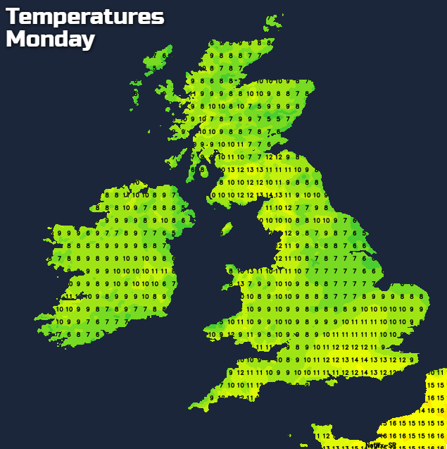
It was the warmest day of the year so far yesterday, with Gravesend (Kent) reaching 19.4c, there'll be nothing like that today though, with 12-14c about as good as it'll get. The reason is that the southerly flow has now been cut off, and we're starting to see winds turn into the east. We're further into Spring now, so this one won't be bitterly cold like our previous easterly encounters, but North Sea coastal counties, are going to suffer from chilly, gloomy, damp weather at times throughout the upcoming week.
For today, we have plenty of cloud and some patchy rain affecting the southeastern quarter of Britain. To the north and west of that, there'll be sunny spells, but also a scattering of sharp showers developing.
 Through this evening and overnight, what was a light northeast wind in southeastern regions, just starts to become a little stronger. Meanwhile, the showers across other parts of the country die out, but that patchy rain also affecting the southeast, continues. By Monday morning, that'll be starting to spread north and west as well, a theme which will carry on throughout the day.
As the rain spreads, so do those easterly winds, setting the scene for much of the week.
Elsewhere tomorrow, it'll be a similar day to today, with broken cloud allowing some sunny spells, but there'll also be some showers around. Temperatures tomorrow will be disappointing close to eastern coasts and warmest in the northwest, along perhaps with the southeast once the rain has cleared north.
Tuesday will see the rain from Monday affecting Scotland, so a dull, damp, chilly day likely here. To the south of all that, there'll still be some showers, and that North Sea coast is going to struggle with low cloud and cool temperatures. But inland, with some breaks in the cloud, temperatures could rise nicely into the mid-teens or so, making it feel quite pleasant.
 Wednesday may bring some more showery rain in from the east, but for most, it should be a dry day with a few sunnier bits in the mix - especially across the southern half of the country. Thursday looks likely to bring more cloud, and more widespread patchy rain and showers. The best of any sunshine and temperatures are expected to be in the west. All the while that East coast continues to be plagued with low cloud, drizzle, showers and chill temperatures.
By Friday and to start the weekend, we may begin to see a slight change, as winds tilt toward the southeast. It's a subtle change as the general theme of variable cloud, and showery rain will continue, but it may give some respite to eastern coastal parts - especially in the northeast. And it's a warmer direction, so temperatures may be on the rise, which in turn could serve to pep up any showers, which could turn quite thundery.