


Apart from Tuesday, rain times for much of the week. Turning much colder from the east at the weekend.
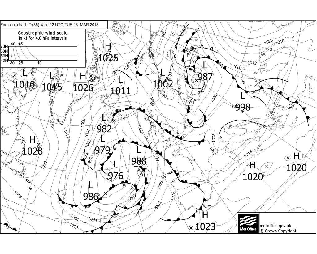
The start of the new working week is looking rather damp for England and Wales, as an area of low pressure trundles northeast across southern England, with showery rain spiralling around it. Scotland will be drier though and today’s showery rain will clear eastern areas overnight to leave Tuesday largely dry and increasingly sunny from the west as high pressure briefly builds. However, it will turn increasingly unsettled and windy from Wednesday, as a low pressure system over the Atlantic moves in and loiters close to the west for the rest of the week, with rain in the west on Wednesday spreading to all parts on Thursday, followed by showers through Friday, though winds easing.
Although most days will see some rain this week, it will be mild, with temperatures reaching double digits in many areas, particularly from mid-week. However, it does increasingly look like the Beast from The East will return at the weekend, as high pressure builds over Scandinavia and pulls in very cold air from NE Europe, bringing temperatures back down into low single digits and some wintry precipitation.
For now, most places are off to a grey start with some showery outbreaks of rain affecting many areas of England and Wales for the morning commute, heavy in places. There are some drier conditions with sunshine to be had though, mainly across western Scotland, more in the way of low cloud and patchy drizzle towards eastern Scotland and NE England, so misty here towards the coasts and over the hills.
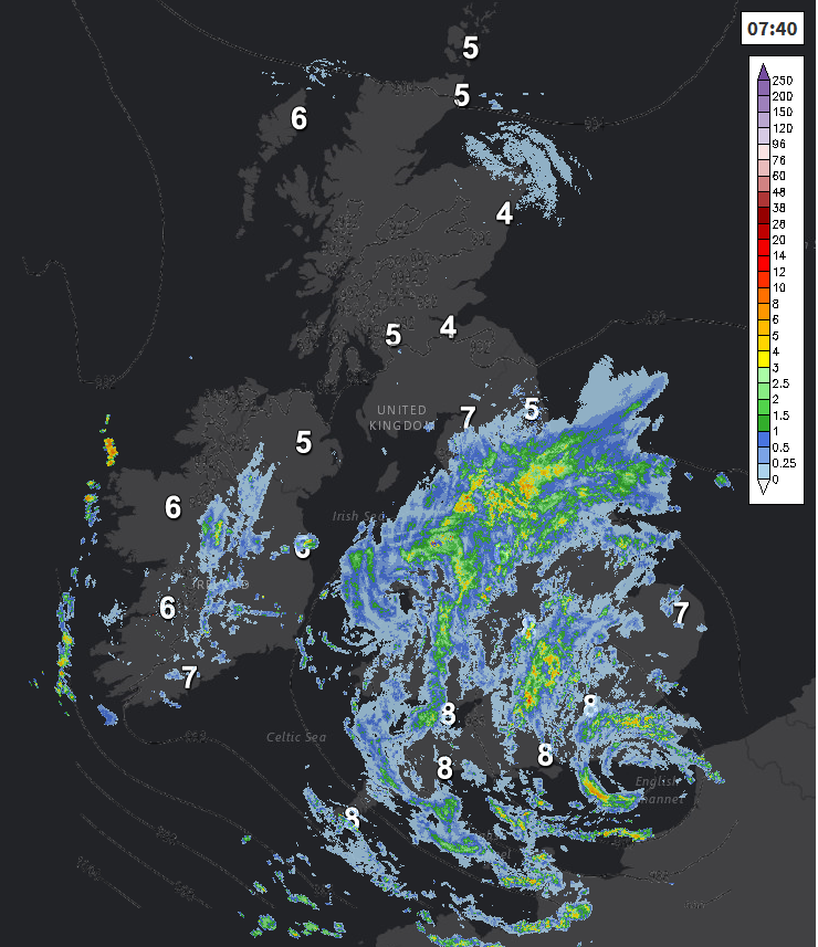
Showery outbreaks of rain will continue across much of England and Wales through the day, spiralling around an area of low pressure moving northeast across southern England, the showers merging into longer spells of rain across NW England, Wales and SW England. Some heavy showers developing towards SE England and East Anglia – where we will see more in the way of brightness, perhaps accompanied by the odd rumble of thunder too. Showery rain spreading up across southern Scotland and N. Ireland too after a dry start to the day, but central Scotland northwards looks to stay mostly dry, with sunny spells in the northwest of Scotland, cloudier towards the east.
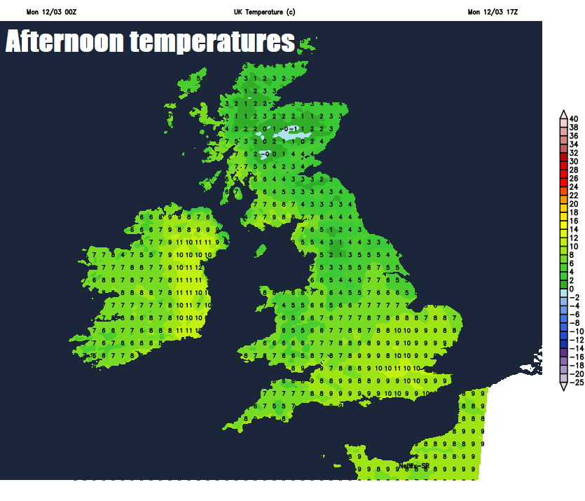
Temperatures reaching 6-8C in the north, 8-10C in the south. Winds generally light, though a brisk easterly breeze towards North Sea coasts of northern England, making it feel chilly, and a strengthening northwesterly wind across the far southwest of England.
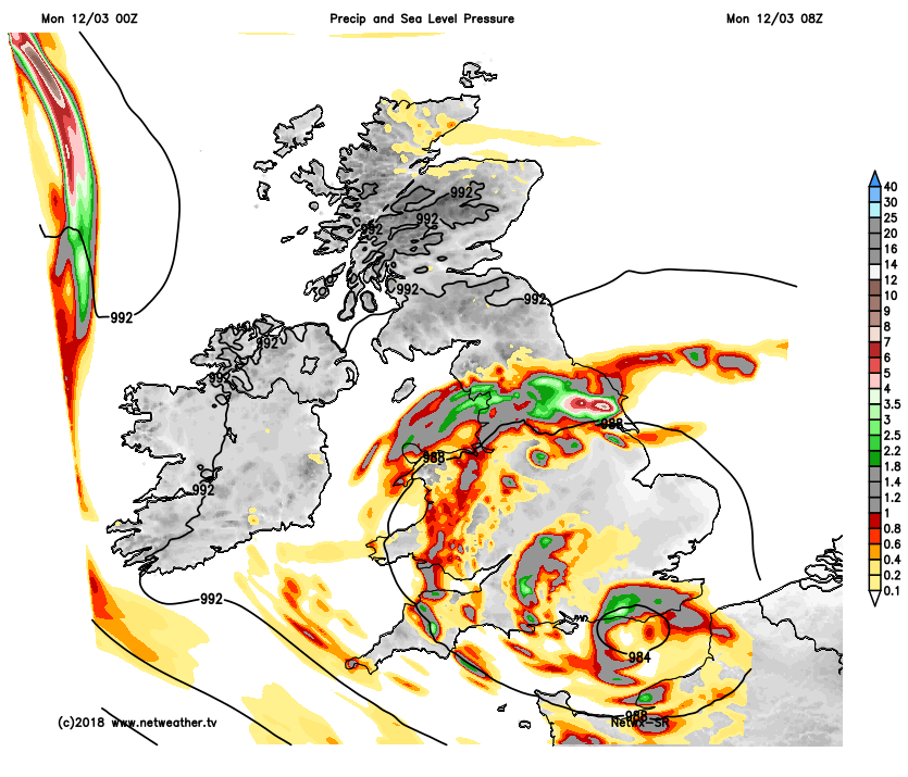
Widespread outbreaks of showery rain across England, Wales and southern Scotland as we head through the evening and into the night. Mostly dry for northern Scotland overnight and becoming drier across N. Ireland. Showers will gradually ease from the west across England and Wales in the early hours of Tuesday, with showers becoming confined to eastern England.
A more promising day tomorrow, with a ridge of high pressure building in, so any early showers across eastern England fading to leave most areas to enjoy a dry day with increasing amounts of sunshine developing from the west. Though it will cloud over from the west across Ireland and N. Ireland by the evening, thick enough for some light rain or drizzle. Temperatures reaching 7-9C in the north, 9-12C in the south.
Wednesday is looking largely cloudy and windy across northern and western areas, with patchy outbreaks of rain, which will turn heavy across the far west, as a frontal system moves in across the west ahead of low pressure close to the west of Ireland. Central and eastern England could stay largely dry, though increasingly cloudy from the west after a bright start.
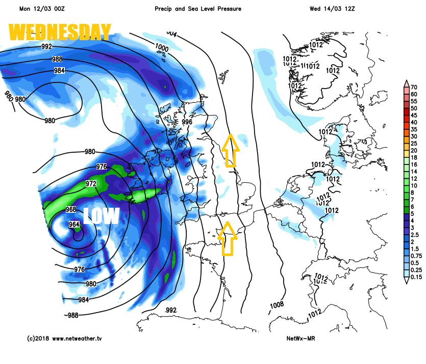
Rain across the west on Wednesday spreading slowly eastward overnight and through Thursday, with northern and eastern areas seeing a generally cloudy day with patchy rain, windy everywhere. Perhaps turning brighter and showery across Wales and SW England. The brighter and showery conditions then following the rain northeast across England and Wales on Friday, however, cloud and rain may linger across eastern Scotland and NE England, drier in the far northwest.
It then looks like turning increasingly colder from the east at the weekend, as high pressure builds and intensifies across Scandinavia, which looks to pull in an increasingly cold and raw easterly wind, the cold air sourced from a very cold Scandinavia and NW Russia.
So, we may see increasingly wintry showers develop towards eastern coasts. It doesn’t look like there will be any disruptive snow for now, and the cold won’t be as intense as the beginning of the month, but it will feel noticeably colder with a risk of overnight frosts.


