


Rain spreading north across all parts today & tomorrow, increasingly mild, Sunday drier & brighter

After a cold night in many areas, many central and northern areas will have a dry Friday with good sunny spells, however, cloud and rain will spread north across southern England and Wales during the day. The cloud and outbreaks of rain arriving in the south later affecting most areas through Saturday, while turning rather mild in the southerly breeze, with temperatures perhaps reaching the mid-teens in the south. Sunday’s looking somewhat better, with drier and brighter conditions for many once early rain clears the north of Scotland, though with some showers arriving across southern England. Remaining unsettled next week, with low pressure close by bringing outbreaks of rain or showers at times. Generally mild, but cold enough in the far north for some hill snow occasionally.
For now, clear skies overnight mean it’s a cold and dry start to Friday for many, especially more rural areas, where temperature have fallen close to freezing – leading to a risk of ice, southern counties of England largely escaping a frost – where we have more in the way of cloud. The exception to the mostly dry start is across northern Scotland – where wintry showers have pushed in overnight from the west, bringing snow over higher ground and a risk of ice with temperatures near freezing. As well as a risk of ice there is also some fog patches to watch out for across parts of the Midlands.
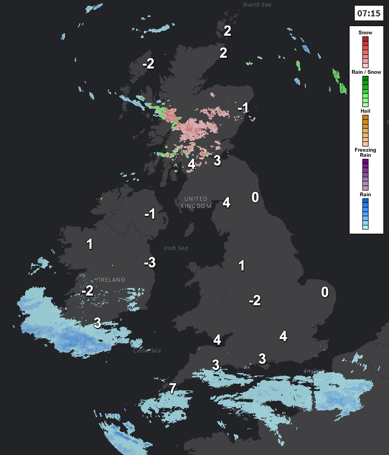
It’s less cold across the far south, because the breeze is picking up and cloud is spilling in from the south, heralding outbreaks of rain, already across far SW of England, will which will spread north across southern England and south Wales through the morning, then across north Wales, The Midlands and East Anglia through the afternoon, after a dry and sunny morning here. Further north across northern England, Northern Ireland and much of Scotland it will be a dry and sunny day with light winds, though still a few wintry showers affecting northern Scotland.
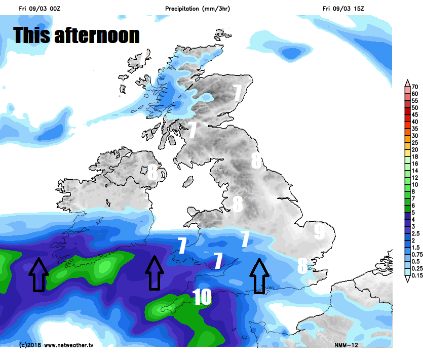
Temperatures reaching double figures across the far SW of England and the Channel Islands, otherwise staying in single digits, reaching 7-9C generally, but feeling pleasant in the sun with light winds in the north.
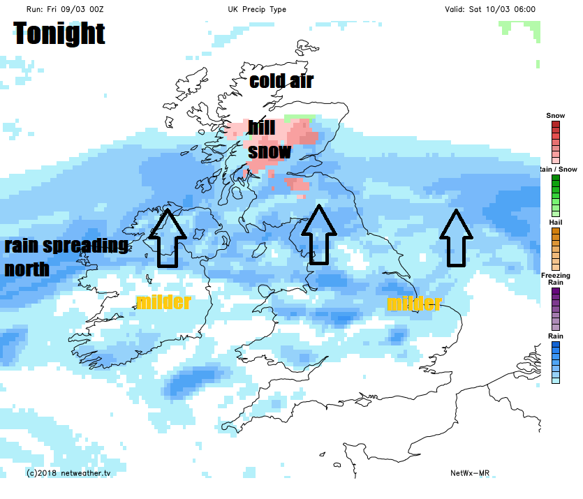
Cloud and outbreaks of rain continuing to spread north across England, Wales, Northern Ireland tonight and eventually southern and central Scotland by the end of the night, milder air filtering in across the south, turning higher ground misty or foggy. Perhaps some hill snow across the far north of England and Scotland, as the rain bumps into colder air here. Cold and clear across northern Scotland for much of the night, with a frost developing in places.
Cloud and rain will continue to spread north from northern England and N. Ireland across Scotland through the morning and into the afternoon accompanied by a brisk easterly wind, with some snow falling over the Scottish mountains. Staying often cloudy across England and Wales, with further showery rain spreading north, though with some occasionally bright or sunny spells too. Still on the cold side across Scotland – where temperatures will reach 5-6C. Turning increasingly mild from the south across England and Wales – with temperatures reaching 10-13C, perhaps as high as 14-15C across southern England, so feeling pleasant in any sunshine. So quite a contrast either side of the Scottish border.
Sunday perhaps not quite as mild in the south as Saturday, but even so, a mild day across many areas, but mostly dry and bright or sunny spells once early rain clears Scotland in the morning. There will be a few showers spreading up from the south across southern areas of England and Wales through the day though and risk of more persistent rain clipping North Sea coastal areas of eastern England. Temperatures reaching 9-11C in the north, 10-14C in the south.
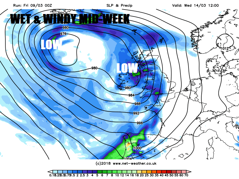
Monday is looking predominantly dry across Scotland, but England, Wales and N. Ireland will see a mixture of sunshine and showers, as low pressure moves east across southern Britain. Tuesday may end up the driest day of the week, just a few showers in the south, rain reaches the far west in the evening, before spreading across all parts on Wednesday, which looks to turn out to be a wet and windy but mild day, with gales developing in the west.
Rain clearing early Thursday to sunshine and showers to end the week, risk of frost where skies clear overnight, particularly in the north.


