The numerical weather prediction (NWP) models have exhibited a lot of volatility over the past week with regards to predicting the evolution of pressure patterns past day 5, which each twice daily run of the ECMWF and UKMO and four daily runs of GFS showing wild swings in evolutions between each run, some bringing a cold easterly by the end of next week, then the next run bringing a taste of spring by the end of next week.
Ever since a sudden stratospheric warming (SSW) occurred at the start of the week, where winds in the stratosphere reversed from westerly to easterly, there has been low predictability afforded by the operational runs of the GFS, UKMO and ECMWF and even the ensembles have been showing large spread early on.
Well, it appears it could be to do with issues over how the models are handling the coupling of the stratosphere and troposphere below (where our weather occurs), as the downwelling of the SSW eventually impacts the troposphere, as the reversal to easterly winds propagates downwards.
Cross section of atmosphere shows wind reversal to easterly (blues) earlier this week propagating downwards
The SSW early this week has caused the stratospheric polar vortex to split into two, with ‘daughter vortices’, one larger one heading over Canada and the other smaller vortex wandering into NE Europe. But the models may have some resolution issues around the tropopause where the stratosphere – troposphere coupling takes place. The NWP model performance could be compromised by their limited resolution of handling of the movement and strength of the daughter vortices and how this imprints on the troposphere and thus upper flow configuration that drives our weather patterns. The NE Europe vortex looks like moving west but remaining detached from the stronger Canadian vortex –which itself may endure weakening as further wave breaking working up from the N Atlantic domain of the troposphere impacts the vortex. It’s how the models handle and correctly model these interactions that maybe causing them to falter, which could ultimately be to do with how individual models are calibrated.
Stratospheric Polar Vortex splits into two 'daughter' vortices
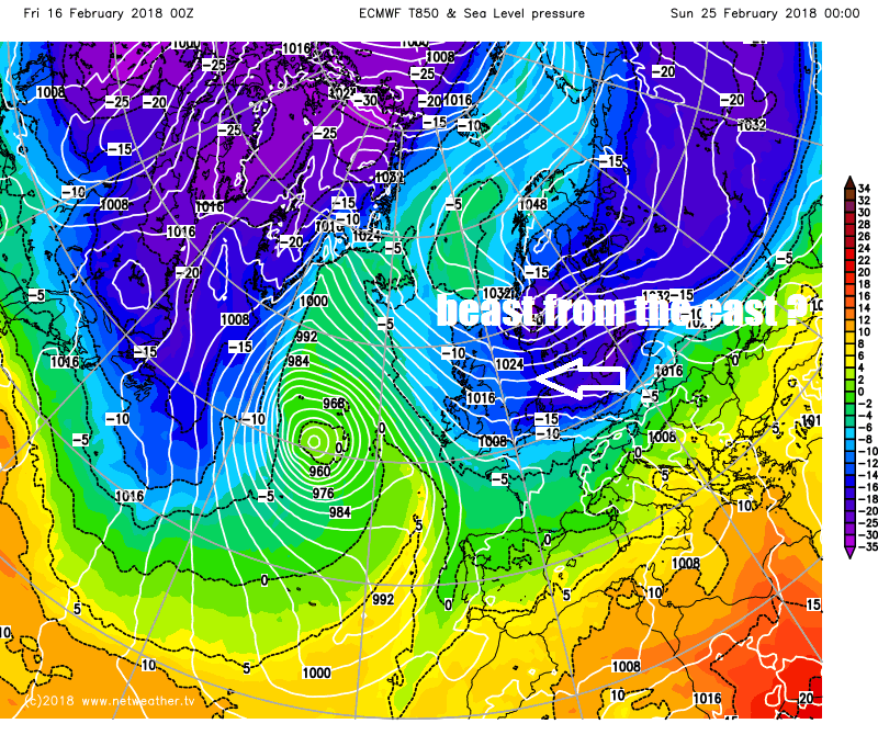
So we have seen some notable differences between output yesterday, with UKMO going for an easterly next Wednesday on the 00z run, then dropping it on the 12z. ECMWF bringing a mild southwesterly flow next Friday on the 00z run, then bringing a cold easterly flow on the 12z for the same day. GFS four runs yesterday generally bringing a large blocking centred over or to the east of the UK.
Yesterday's 00z runs had notable differences as early as day 5 between GFS, EC and UKMO
The 12z runs again brought differences, the ECMWF bringing in an easterly it didn't have before
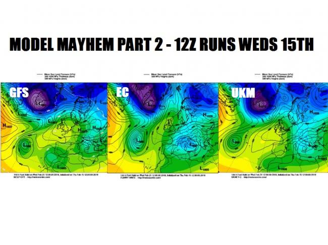
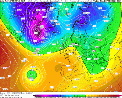
This morning runs again have big differences again, at day 6 (144 hours) the 00z GFS and ECMWF operational runs exhibit differences with the amplitude of the jet over the N Atlantic, and quite clearly the cold pooling/troughing over Europe, look at GFS ridge into western Europe! But also the GFS trying to phase the Canadian and Russian trop vortices to the north.
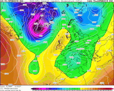
The 00z ECthis morning produces a Scandinavian high to bring an increasingly deep cold easterly from day 6 to day 10, while the GFS shows low heights dominating to the north, bringing a less cold predominantly westerly flow.
So, lots of uncertainty in the forecast for next week, so weather apps and online automated forecasts from the likes of BBC, Met Office or those that use the GFS like Netweather you may find unreliable as they keep changing. So here is where some human input may be valuable trying to decipher what is going on by using ensemble guidance which is more reliable at such lead times, but also using empirical forecasting techniques and analogues of previous stratospheric events against similar background atmospheric states (such as La Nina, easterly QBO and low solar activity like now). A SSW, more often than not (66% of the time) leads to blocking high pressure to the north or northeast of the UK bringing colder weather than average some 10-15 days later. The current SSW still looks on course to bringing just that, given favourable background state, though we may have to wait until the very last few days of February or early days of March to experience deep cold and snow.
Loading recent activity...