


Less cold today, with cloud and rain for some, turning colder from the NW on Friday, then milder and wetter on Saturday.
It will be less cold today than it has been this week so far, though the southeast will have a cold start thanks to clear skies hanging on here overnight. There is a change afoot from today to more unsettled conditions over the coming days, including through the half term week, thanks to a strengthening Atlantic jet stream. Temperatures will be up and down too, with milder spells coinciding with cloud and rain, like today, while colder polar air following weather fronts bringing the rain will be associated with sunny spells but also a risk of wintry showers in the north and northwest.
So, Thursday is off to a much milder start across much of England and Wales, with cloudy skies and outbreaks of rain across the far NW of England and west Wales and drizzle elsewhere across the west. The exception is across SE England and East Anglia – where skies have remained clear and the cold still lingers allowing for a hard frost to start the day, temperature as low as -6C at Shoreham near Brighton on the south coast. After the cold start in the southeast, cloud will spill in from the northwest, though staying dry, but temperatures perhaps struggling with lack of sun here to warm it up. Rain or drizzle on off and breezy for northern England, Wales and western areas of England for much of the day the rain perhaps turning heavier across Wales in to the afternoon, with some patchy light rain getting into the Midlands too. Temperatures perhaps reaching 9-10C across SW Wales and far SW of England, otherwise temperatures reaching 6-8C generally.

.png)
For Scotland and Northern Ireland, any early cloud and rain soon clearing the south to sunny spells with showers across Northern Ireland, northern and western Scotland. Temperatures reaching 6-8C, though falling across the northwest in the afternoon, as colder air digs in.
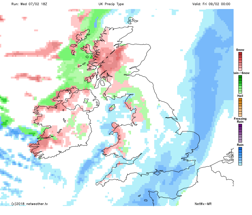
Some heavy rain developing from the southwest across Wales and northern England this evening, as the front bringing today’s rain re-invigorates and develops waves along it. The rain accompanied by a brisk southwesterly wind then spreading eastwards across England tonight, reaching the east, while clearing Wales and western England to clearer skies and a few coastal showers, which will turn increasingly wintry in the northh.
Clearer skies further north for a time, but turning increasingly cold across Scotland, Northern Ireland and NW England, with frequent showers moving in across N. Ireland towards western Scotland falling increasingly as sleet and snow and perhaps merging into a longer spell of snow moving southeast across Scotland, the Met Office have a warning out for snow and ice:
Rain clearing southeast England first thing on Friday, then sunny spells and showers for most, especially in the morning before high pressure builds in bringing fewer showers in the afternoon in the south. Showers driven through by a brisk northwesterly wind, so temperatures will be dipping again and showers will fall as a mixture of rain, sleet, snow or hail almost anywhere. Snow accumulations confined to hills in the north at first, but perhaps increasingly a risk of a covering at lower-levels later in the day. Temperatures reaching 5-7C, but add on the wind chill and it will feel colder than this in the north.
Saturday is looking the wetter, windier and milder of the two weekend days, as an Atlantic frontal system spreads rain and strong winds eastwards across all areas through the day, the rain heavy across the north and west. Colder and clearer conditions moving in across Scotland in the evening, with sleet and snow showers for the far northwest. These colder and clearer conditions following across other northern and western areas Saturday night.
Rain clearing eastern England first thing on Sunday, then all areas under a colder polar northwesterly flow, remaining dry and sunny but chilly for many away from western coasts – where we will see frequent sleet and snow showers through the day, bringing some accumulations, even to low levels in the north.
Continuing unsettled and windy at times next week with temperatures fluctuating in the strong westerly flow. Mild with areas of cloud and rain moving through off the Atlantic, colder with clearer but showery polar maritime flows, showers falling as snow in the north and west in the colder flows.


