Generally dull & mild conditions over the weekend and into Christmas Day, rain for northern areas. Windy & unsettled for all next week.
We could have done with some sunshine yesterday on the winter solstice given the least amount of daylight of the year, but alas, for many it was rather dull – which made the onset of dusk even quicker. If you are hoping for glimpses of the sun today and in the run up to Christmas, you may be disappointed to hear that the mild and moist southwesterly flow will continue to feed in mostly cloudy skies, even on Christmas Day. But Boxing Day onwards will see the weather shaken up, as the jet stream that’s been to the north of the UK moves south, bringing low pressure systems across the UK, so it will turn more unsettled, windier and wetter for all, but with some sunny spells between weather systems too. It will turn colder too, with a risk of snow in the north, particularly over higher ground.
For now, it’s another dull, murky but rather mild start for many of us, with patchy rain spreading southeast across southern and western areas during the night still lingering this morning across southern counties of England. There is also some fog around across central areas and the west. However, clearer skies across northern Scotland overnight has led to frosty start in more rural areas, with temperatures as low as -2C in the Highlands.
Eastern Scotland may hang on to clearer skies to bring some sunshine through the day and we may see some brightness develop in the lee of the Pennines across NE England too. But for many it will be a dull and murky day, with low cloud hugging western hills, thick enough to bring drizzle or patchy light rain, eastern areas staying mostly dry though. Perhaps more persistent light rain and freshening winds developing across western Scotland by evening. A mild day across the board, with temperatures reaching 9-12C generally, though cooler than this across eastern Scotland.
.png)
Nothing will really change much as we head into tonight, cloudy and murky for many, with further light rain or drizzle across western Scotland, some patchy drizzle further south over hills of NW England and Wales too. But elsewhere dry and all parts mild and frost-free with winds generally light away from the far northwest. Perhaps some clear spells in eastern Scotland leading to a chilly night here.
As we head into the weekend, it looks to stay mostly cloudy but mild as the moist southwesterly flow off the Atlantic continues. There will be more of a breeze developing on Saturday, which will tend to lift the fog off the hills after a murky start in the morning. For most it will be dry, but western Scotland will see persistent rain develop. Perhaps some brightness developing to the lee of high ground across eastern Scotland and NE England, but sunshine will generally be in short supply.
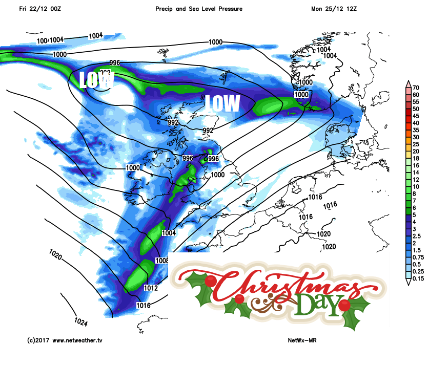
Dry for many in the south this weekend, thanks to high pressure, but rain spreading down across Scotland on Saturday and eventually other northern and later western areas on Sunday.
Little change for much of England and Wales as we head through Christmas Eve, staying generally cloudy but dry and breezy. However, a band of rain will slowly work down across Scotland through the day, reaching Northern Ireland and far north of England by evening. Persistent and heavy rain continuing across western Scotland until Monday, with some high rainfall totals building up bringing a risk of flooding. The Met Office have a warning out for parts of western Scotland for this rain.
Christmas Day continues the cloudy and mild theme for most, a slow-moving low pressure system close to Scotland will bring outbreaks of rain for much of the day with snow over northern mountains as colder air filters in, while a band of rain spreads slowly south and east across Northern Ireland, the north of England, Wales and far SW of England through the day. Staying mostly dry and cloudy further south and east away from southern counties - where we could see some drizzle.
Overnight rain clearing east first thing Boxing Day, followed by a brighter and colder morning, though with some wintry showers in the north, before wind and rain preceded by some snow over northern and western hills to end the day. Remaining unsettled and windy for the rest of the week, with spells of rain or showers, heavy at times, affecting all parts, with snow over northern hills. Gales or severe gales are likely at times, as a few deep lows move through and it will turn colder at times in the south behind these lows and generally staying cold in the far north.