If you part of Frantic Friday or just leaving it all until Christmas Eve, the weather doesn't look too bad. Just one or two things to keep an eye one in the run-up to Christmas.
Issued Thurs 21st Dec 10pm
The roads were already getting busy. Whether that is Christmas shoppers, food shoppers, people who have finished work a day early or just general winter congestion.
It could have been people trying to avoid Frantic Friday, but Saturday is also forecast to be a very busy travel day. Currently, there doesn't look to be any major weather worries to add to the high volume of traffic, so that is good news. Overall the weather doesn't look particularly severe in the Christmas build up, but there will be the risk of fog again on Friday, strong, gusty winds at the weekend and maybe issues from heavy rain Sunday into Monday.
Friday 22nd - Frantic Friday
There will be misty murky, grey conditions in the morning with fog in places. People setting off early on Friday will need to watch out for this, as it will be patchy. Make sure your washer liquid is full, and turn your fog lights off again if you do put them on.
The industrial action which was going to affect Virgin Trains has now been called off, although there still could be some disruption.
@Merseyrail Fri 22nd: "There will be no trains running on the Ellesmere Port or Hunts Cross lines during the strike action and some stations may be closed."
The mild SW winds begin to pick up over northern Scotland through Friday night. Gusts around 65mph will blow by Saturday morning as rain arrives.
Saturday 23rd
With hardly any train services on Christmas Day or Boxing Day, Saturday will be very busy. There is also an early shutdown on Sunday, Christmas Eve, so do consult with revised timetables, not just assume that the usual last train will arrive. There will be a lot of network improvements going on during the festive period.
Saturday will start off quiet and still for southern England with a low risk of early fog but hopefully not resulting in issues for any of the London airports. Much of the UK becomes more blustery with strong winds for Scotland, into NE England by Saturday afternoon and evening, gusting 50 to 60mph
Sunday 24th
Rain over NW & N.Scotalnd will set in for western Scotland and the UK Met Office do have a Yellow Be Aware warning for heavy rain. This runs throughout Sunday, Christmas Eve and highlights surface water and spray and the risk of localised flooding. Keep an eye on the SEPA website for local road and rail updates.
It also looks wet and windy across Northern Ireland, southern Scotland, Isle of Man and parts of Northern England. Not too severe but still not ideal conditions for being out and about if you are a very last minute shopper.
Christmas Day
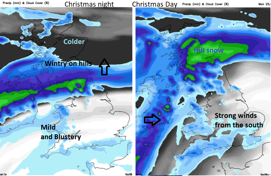
The rain warning covers more parts of Scotland by Monday. The area could change so watch out for updates. This frontal band will also turn to snow over the Scottish mountains Not much chance of a white Christmas for most of the UK but there is a signal for lying snow for the Grampians and Highlands. Most places will be mild and become windy with more rain. By Monday evening, the weather will be wet and windy for SE Britain, not very nice if you are driving home after Christmas dinner.
Rail information- times and updates