We have a few days left of autumn, but the weather is already ahead of itself and into winter mode.
We have a few days left of autumn, but the weather is already ahead of itself and gone into winter mode for the rest of the week, as a northerly wind feeds in cold air direct from the arctic.
As is often the case in a northerly flow in the colder months, the associated wintry showers tend to be confined to windward coastal areas, creating what is known as ‘wishbone effect’ when you look at the shape of Britain’s coastline. With areas away from coasts staying dry and sunny, unless a trough in the flow brings organised precipiation inland, though this seems a low risk this week. It looks to turn less cold at the weekend and into early next week, but there are tentative signs the cold will return in early December, perhaps next week.
Showers continue to affect areas exposed to the northerly wind tonight, especially NE Scotland, NE England, western Ireland, west Wales and far SW England. Showers wintry with sleet and snow over the hills, mostly rain lower levels away from NE Scotland.
Turning colder over the next few days, as the northerly flow continues for rest of the week. Temperatures even in the south Thursday and Friday reaching 5C at best.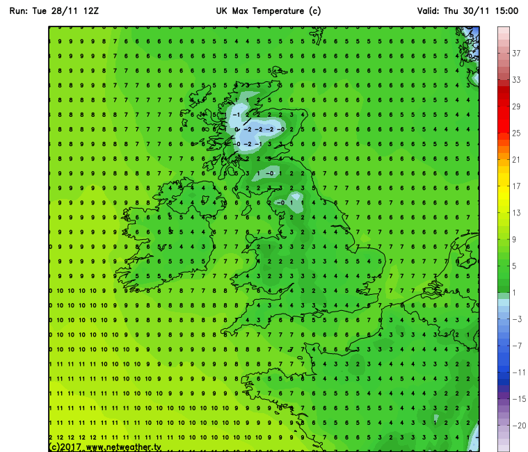
Showers in the east will tend to spread further south to affect Lincolnshire, East Anglia and far SE of England from tomorrow and will have a wintry mix of rain, sleet and perhaps wet snow at lower levels. Settling snow most likely to be reserved for higher ground.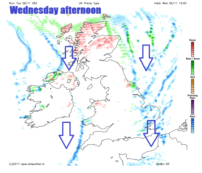
Further showers are likely near western coasts too, though wintriness reserved for higher ground – with temperatures a little higher in the west.
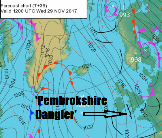
The Met Office fax chart shows a ‘Pembrokeshire Dangler’ tomorrow, that twig-like feature, a name given to a convergence zone common in northerly flows, which feeds a line of showers down across Pembrokeshire and Cornwall.
Showers will eventually tend become most numerous and frequent toward eastern coastal areas, where the northerly wind will be strong and closer to low pressure to the east.
Mostly dry and sunny but still cold away from these eastern and western coastal areas along with far north of Scotland.
Temperatures falling below freezing at night, leading to frost where skies clear and a risk of ice where showers have fallen.
Looking ahead at the weekend and beyond, it turns less cold at the weekend, as winds back from northerly to a northwesterly direction, which will bring in milder martime air from the NW Atlantic rather than the cold and dry arctic. Frontal systems will also spread southeast across the UK over the weekend, bringing cloud and some rain. By Monday, models suggest temperature recovering into double figures in the south, but by no means very mild, given the northwesterly flow.
Beyond Monday, and the confidence in model guidance drops dramatically for our part of the world. The bigger picture is more straight forward: upstream, troughing stretching from Siberia to Alaska above ridging over SE Asia will continue to drive a strong east Pacific jet which extends its strong zonal flow energy over N America, keeping cold air bottled up over N Canada and driving a strong jet over the top of the current block high in the Atlantic bringing us a northerly this week.
Complicated upper flow pattern next week = low confidence on potential for cold to return or staying mild
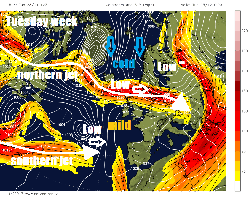
The zonal flow energy upstream tending to flatten the N Atlantic/ S Greenland blocking ridge this weekend to allow some upper troughing to extend SE towards the UK, bringing surface lows and less cold air from the NW Atlantic with it. But, the upper flow over the North Atlantic is complicated by a split flow caused by the current block. The conundrum for the models is trying to model the formation and track of areas of low pressure along both of these meandering southern and northern branches of the jet stream over the Atlantic - which seem to be causing each operational run of the more relied-upon models (GFS/ECMWF/UKMO) to bring out various scenarios and quite different outcomes for the UK in the medium range in terms of temperature and precipitation.
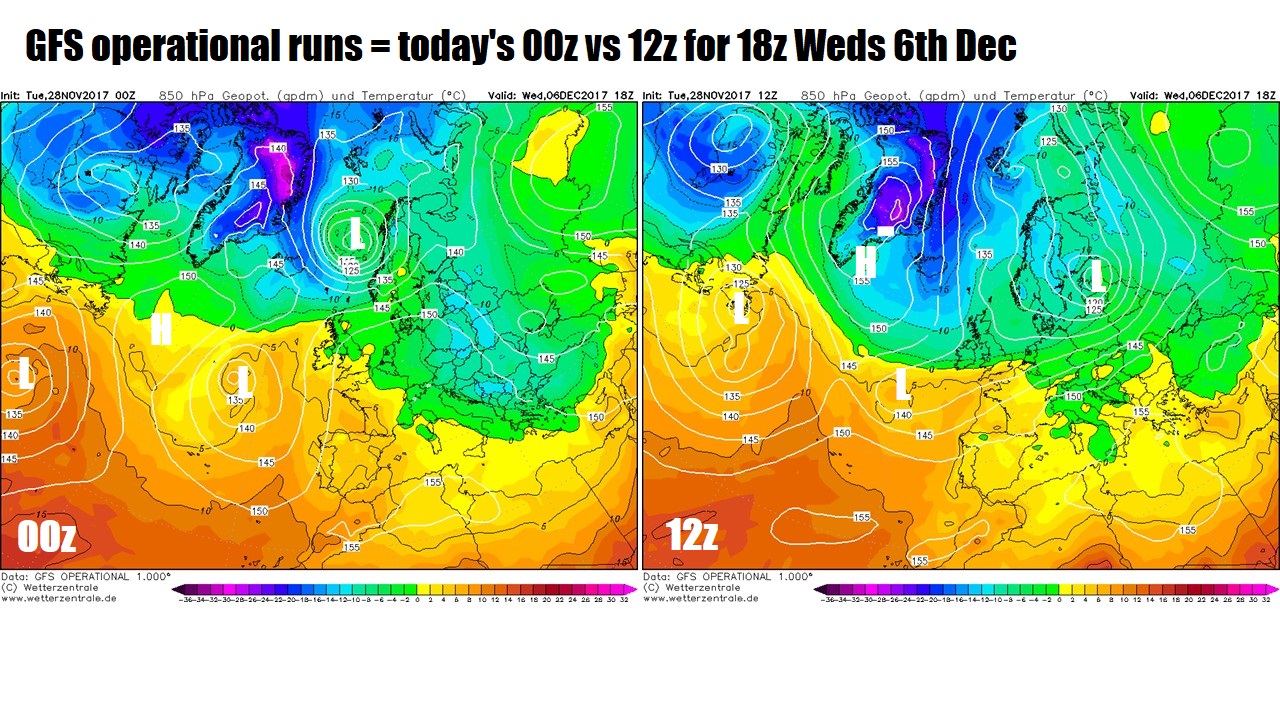
For example, Sunday’s operational output were suggesting a very cold arctic northerly blast reloading early next week. The models then moved away from this idea, with the 00z runs this morning from GFS/ECMWF/UKMO pushing upper troughing east over the Atlantic in association with the southern jet extension, which in turn pushes the mid-Atlantic block east towards western Europe – which prevents cold arctic returning as far south as the UK. However, the 06z GFS operational run today, brought back a bitterly cold northerly blast down across the UK, though not early in the week, but mid-week. The 12z operational run of GFS brings a cold northerly flow back later next week too, as blocking re-establishes near Greenland.
Longer-term prospects for early to mid-December, looking at the wider picture in the northern hemisphere, do look fairly encouraging at the moment for episodes of colder and perhaps wintry weather for the UK, though interspersed with the occasional mild spells.
GEFS forecast Arctic Oscillation, credit: weathebell.com
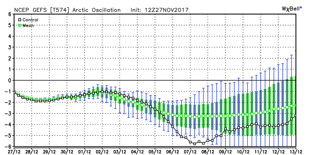
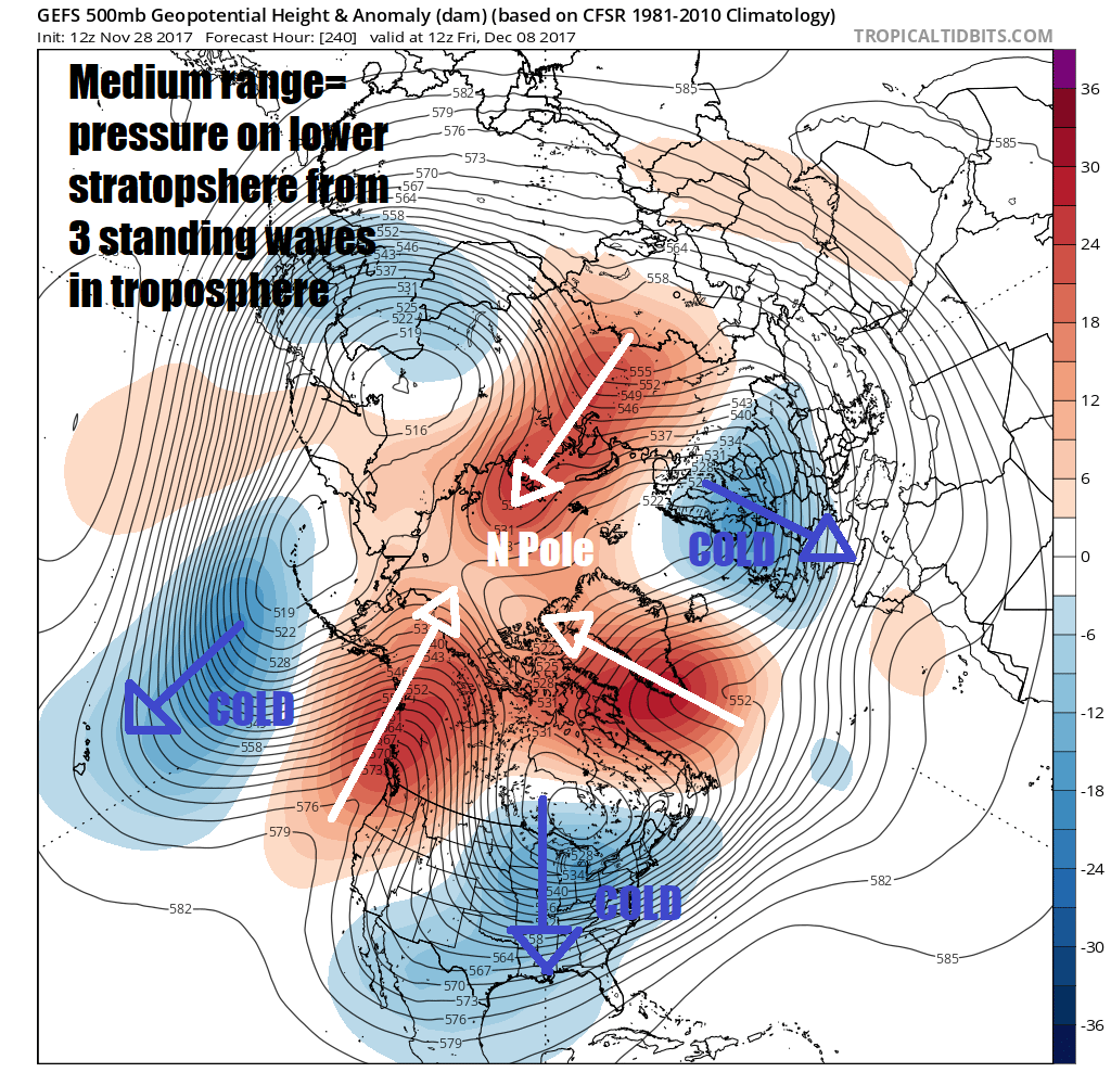
Although the mid-Atlantic block looks to be supressed this weekend, allowing less cold air to return, there appears to be a background pattern of higher pressure/heights over polar regions forecast as an increasingly negative Arctic Oscillation (-AO) by models. This tends to push out colder air from high latitudes to mid-latitudes in winter, amplifying ridges and troughs in the upper flow, then it’s a case of being on the right side of these ridges and troughs to get in the colder air pushing south in the troughs. Into early December, a pattern change looks to take place upstream over the N Pacific, perhaps in the second week, where the currently strong east Asian/East Pacific jet looks to weaken, which will allow a long-wave ridge to form along or off the west coast of N America, with a deepening trough over the eastern side. We then end of with a three-prong ridge attack towards the pole in the troposphere (where our weather takes place) – with long-wave ridges over NE Pacific/ N Altantic and western Russia. These ridges bringing warming poleward and upwards to the lower stratosphere, which has implications of weakening and displacing the stratospheric polar vortex from the pole – which will help in development of colder patterns this early winter.