
The Atlantic is going to feed in several low pressures in coming days. This means wet and windy weather with the possibility of stormy conditions, SW coasts looking most likely by the weekend.
Whether you started the week with stormy Ophelia or just the strange skies, we have a brief lull before several spells of wet and windy weather move in, starting on Thursday and then potentially picking up at the weekend. We still have warm air for the SE although it's cooling off elsewhere at night.

This morning there is a lot of cloud about, it is grey and murky, damp in places. Northern Ireland has some mist and fog, and there have been touches of frost in the far north. SE Britain will see further outbreaks of rain from a set of weather fronts and there will be a lot of cloud over much of England and Wales. Northern England will see breaks and sunny spells. Northern Ireland will brighten up and see sunshine with a more mixed picture over Scotland, lots of cloud inland but brighter sunnier skies for coastal counties. The winds will be from the east until the southerly breeze sneaks back into SE England and lifts temperatures to 20C. Much of the UK will feel fresher and cooler, especially along the east coast
Any lingering rain will clear off from The Wash and this evening looks cloudy and murky, cold in the north with a southerly breeze which will pick up through the Irish Sea overnight.

Areas of rain begin to head into the UK, from the far NW, little lines coming up from the Channel. Thursday will again be quite mixed across Britain with cloudy areas and bright or sunny spells. The main frontal rain arrives around lunchtime into western Northern Ireland. There are signs that a pulse of rain ahead of this band will invigorate as it heads north through England. So, there will be heavy bursts of rain about and in-between fine weather with sunny spells.

By Thursday evening, the main band of rain should be over Northern Ireland and SW Britain with some heavy and persistent rain. We’ll have to see if the pulse of rain clears off into the North Sea around Yorkshire or grazes along the coast right up into Aberdeenshire.
The winds veer from a southerly to a colder north-westerly as the frontal band moves across Wales and into England. The whole lot then heads off to Grampian and the Northern Isles by the start of Friday. The low pressure responsible for this bout of wet and blustery weather will take another band of rain across Britain on Friday morning, but this fades. So, we should see a spell of fair weather on Friday afternoon into the evening.
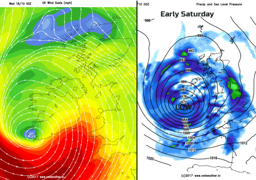
Stormy Weekend?
There are concerns already about the amount of rainfall the strength of the winds and large waves at the weekend. Depending on the developments of a deep area of low pressure out in the Atlantic we could see gales and high rainfall totals. Starting with SW winds Friday night into early Saturday with the potential for severe gales around SW Britain’s coasts. If the low pressure does track right across the UK, it will be southern Britain which bears the brunt of the strong winds and gales, with rain across most of the UK. By the end of Saturday, if the low tracks off into the North Sea, the high gusts and rain will pull across a central swathe of the UK. There is still uncertainty about the actual track and the impacts of this low/storm, as it only just beginning to show its cold tops on the IR (infrared) satellite picture, right on the other side of the Atlantic.

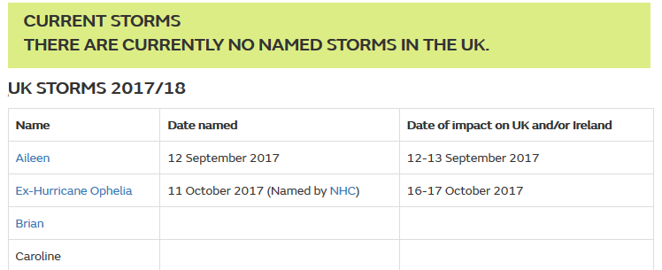
If Met Eireann or the UK Met Office decides that the impacts of this low warrant an Amber (or Red) warning for Wind or Rain, then it will be named #StormBrian. Currently, there are no weather warnings from either bureau, a yellow Be Aware warning may be issued today to highlight the shape of the forecast for the weekend, but so far there is no name, and too many random people are jumping the gun. And after the real impacts and events of Ophelia (a former hurricane) this week, how helpful is the early/madeup naming of a Storm on social media? This being the third time, at least, that Brian has been named.
Yes, there is the potential for stormy weather this weekend but for now, keep an eye on the forecast and watch out if the warnings do appear. It is autumn after all.


