


Rain spreading SE today, heavy and persistent in the north. NW-SE split rest of week and through the weekend, but warm, with 23C possible by Sunday.

Like the last few days, a strong and moist flow off the Atlantic brings more cloud for many today, but with the addition of heavy and persistent rain this morning across the northwest as a cold front bumps into the warm and moist southwesterly flow, before the front clears the rain southeast through the day. Clearer and cooler conditions follow from the northwest, leading to a chilly night tonight, but for the rest of the week and into the weekend a northwest-southeast split develops, with northern and western areas generally cloudy and windy with rain at times, while southern and eastern areas are drier and warmer with sunny spells. With a long draw southerly flow this weekend, we could see temperatures reach 23C, so feeling summer-like for mid-October.
So Wednesday morning starts on a very wet and windy note across southern Scotland, Cumbria and Northern Ireland. Persistent rain overnight across western Scotland has brought 50mm (2 inches) in 12 hours and across Cumbria we could see up to 100mm (4 inches) and across north Wales 50-80mm, before the rain clears here by early evening. So this could lead to some local flooding in places.

We will see persistent rain and strong winds setting in across Wales and northern England too this morning, further south grey skies will bring patchier and lighter rain or drizzle. The rain across Scotland and N. Ireland this morning will clear to brighter conditions and easing winds from the northwest this afternoon, though with some showers towards northern and western coasts. The rain and strong southwesterly winds across Wales and northern England will gradually shift southeast into SW England, the Midlands and parts of eastern England, but rain turning lighter as it does so. Mostly cloudy with patchy drizzle ahead of the rain across parts of southeast England, though the odd glimpse of sunshine can't be ruled out.
Despite the cloud and rain, it will be quite mild and muggy across England and Wales, temperatures reaching 15-18C. For Scotland and N. Ireland, turning cooler and fresher this afternoon, though sunshine should lift temperatures to around 14-15C.
Today’s weakening rain band slipping southeast will eventually arrive across southeast England and East Anglia this evening, before clearing by midnight. Clearer but cooler conditions following across all parts, meaning it will turn chilly, though there will be further showers for the far northwest.
Tomorrow is looking a much better day, as Britain will be between low pressure systems with a brief ridge of high pressure building in. So for many, it will be a dry and fine day with sunny spells, however, a warm front will brush the far northwest, bringing cloud and outbreaks of rain to northern and western Scotland, along with the north of N. Ireland. Temperatures reaching 12-14C in the north, 15-17C in the south.
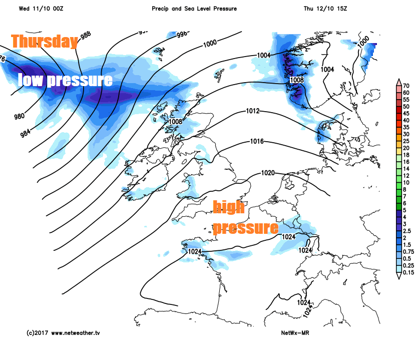
A trailing and wavering cold front associated with a deep area of low pressure passing the south of Iceland will bring cloudy skies and outbreaks of rain to much of northern and western Britain throughout the day. But across central, southern and eastern England it will be mostly dry and bright or sunny and with a long draw southwesterly flow bringing tropical air, temperatures will hit 19-20C.
Temperatures will keep on rising as we head into the weekend, as low pressure systems stall to the west drawing in a warm southerly flow sourced all the way from southern Spain and the western Mediterranean. So across much of England and Wales we will see dry and sunny weather lifting temperatures to 20C as far north as northern England, perhaps as high as 23C across eastern England. However, weather fronts will never be far away from Ireland and Scotland, bringing more in the way of cloud and threatening rain at times too.
For early next week, we are watching the wanderings of ex-hurricane Ophelia, which is currently a tropical storm expected to strengthen into a hurricane to the south of the Azores this weekend, before becoming ex-tropical but still a deep low, as it then heads north/northeast towards far west/northwest of Europe. However, the exact track of this deep low is very uncertain, for now models take it north to the west of Ireland so we’ll keep you posted.


