Issued at 1500BST on Tue 3rd Oct based on Tue 3rd Oct 00Z Model Runs
Key Points
Discussion:
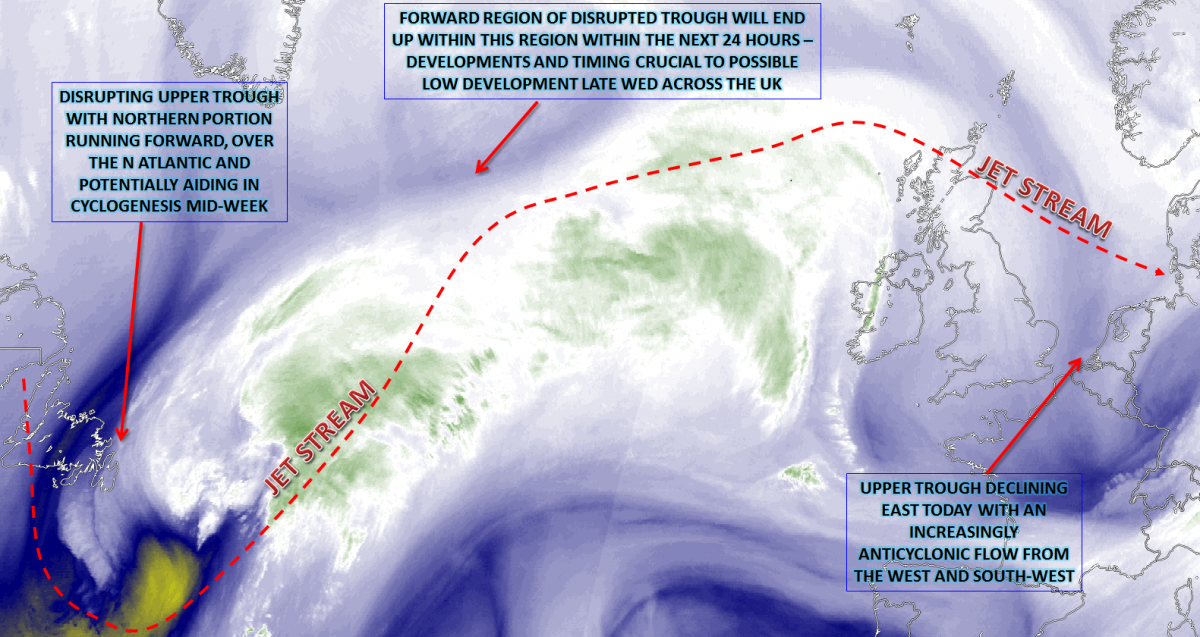
Wed 4th Oct: Into Wednesday and developments to the W will be of primary importance. A zonal jet, especially from the mid-Atlantic into NW Europe, will be a dominating feature of the weather. The disruption of an upper trough over the W Atlantic, over parts of Newfoundland, will have lead to the eastward progression of the northern portion of the disrupted trough. There are model differences regarding this northern part of the upper trough which engages a low-pressure system to the west. The 00Z UKMO and ARPEGE models, for example, allow a greater level of interaction and this leads to a more developed system, with heavy rain and high winds possible. In contrast, the GFS is less developed and takes the low-pressure, perhaps even just a frontal wave, on a far more S’ly track across central and southern areas of England and Wales. Even at this time frame, there are uncertainties over this feature, but it is likely that more central areas of the British Isles will see an increasingly wet and, potentially, windy period of weather later on Wednesday and overnight into Thursday.

Using the 00Z GEM model, as a guide, which has support from the UKMO and ARPEGE, for example, the low pressure moves into the UK, from the W, through the afternoon. The system is well forced, by what looks to be a confluent trough. The marked region of forcing (pink and red shadings) moves in, and the system brings several hours’ worth of heavy rain to S Scotland, N England, Wales and the Midlands. Locally significant rainfall totals could develop, especially over parts of SW Scotland, Cumbria and Lancashire, for example. Depending on the development of the low-pressure, then some high winds may also develop too, on the southern flank of the low, perhaps especially across southern areas of N England, Wales, Midlands and E England later in the day and overnight into Thursday. While Wednesday may well start relatively dry and benign, it certainly looks to end with active-weather moving eastwards, but it is worth highlighting the uncertainty still over the development of this low.

Thu 5th Oct: As we move into Thursday and Wednesday night’s system may still be producing some rain and high winds across more southern and eastern areas of England, first thing, but this will soon clear. Following from the W will be an amplification of the upper pattern. The disrupted trough, from Wednesday, over the far W of the N Atlantic will have moved E, in a still rather continuous flow. However, the downstream effects will be for it to amplify the pattern and allow for a more anticyclonic regime to arrive, from the W, across the British Isles.

The resultant weather across the British Isles, through Thursday, will be for increasingly anticyclonic conditions to develop from the W. However, before that more N and E areas of the British Isles still maintain a more unstable and rather cold NW’ly air flow. Profiles aren’t that unstable, but scattered showers are certainly possible across parts of the N and E, through the day. However, the atmosphere becomes increasingly subsided, from the W. As a result, much of the British Isles will end Thursday predominantly dry with some bright or sunny spells, but it will be chilly. The forecast sounding for Manchester at 1500Z on Thursday afternoon, highlights this prediction well, with a marked region of dry air in evidence.

The other noticeable feature of the weather will be quite pronounced CAA from the NW, in association with the NW’ly flow. 850mb temperatures may well be near to 0C, if not perhaps even slightly sub-zero across the northern half of the British Isles. As a result, despite the ever-increasing settled conditions through the day, with some sunshine, it will be a chilly day. Equally, temperatures will soon drop away into Thursday evening too and a cold night is likely on Thursday night into Friday, particularly when de-coupling of the flow occurs.

Fri 6th Oct: We end the working week high pressure, or a ridge of high pressure, dominating the weather. It will, for many areas of the British Isles, be a chilly start with perhaps some rural ground frost in places. As Friday progress and the emphasis is on a mainly dry day. All the 00Z models (UKMO, GFS, ECMWF and GEM) agree on this pattern, so confidence is high for a rather settled day of weather. Forecast soundings show some broken cloud, so some sunny spells should develop despite variable cloud. The main difference, within the models, is then regarding the potential arrival of a frontal system, from the W, later in the day. The front is unlikely to affect the weather during Friday but will have some implications on the weather for Friday night, regarding minimum temperatures. This feature, in question, can be seen on the MR model, for later in the day, but note the ridged conditions ahead of it across many regions.

Sat 7th Oct and Sun 8th Oct: As we look further ahead, into the coming weekend and, overall there has been a shift away from a more potential period of settled weather now. The overall pattern, across the N Atlantic, is forecast to become more progressive as the transient ridge of Friday declines away to the E and SE of the British Isles. There is a reasonable model agreement for this pattern, so confidence, overall, for the weekend is medium to high. The 00Z GFS model highlights this current evolution within the upper atmosphere well, noting a pronounced vortex is dropping out of the Davis Strait, but the overall flow across the N Atlantic is progressive and W’ly.

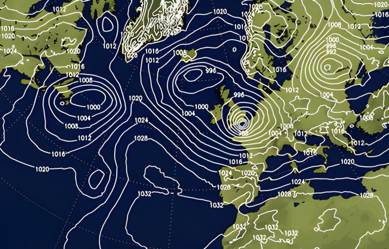
The approaching warm front, from late Friday, is likely to have moved down across much of the British Isles as we progress into Saturday. As a result, overcast and wet conditions will likely be present from first thing. There could well be a subtle low-pressure system as well that sinks SE through Saturday, clearing away into Saturday night, but these details are, for now, uncertain. It is, overall, likely that Saturday will be wet, but with perhaps something of an improvement from the W later in the day. The 00Z GEM, is a useful guide at the moment, noting a subtle low of 1003mb just to the NE of Scotland, while relatively light or moderate, weakly forced, precipitation moves S and E through the day.

Into Sunday and, overall, the details are highly uncertain. Following the frontal systems on Saturday could well be a transient ridge, perhaps especially so across more S and SW areas of the British Isles. However, at the moment, a legacy of mostly cloudy and damp conditions is possible into Sunday with some showery outbreaks of rain, across some N and W areas in particular. Temperatures may make a slight recovery back to nearer average, but given the lack of sunshine and relatively cloudy conditions then, overall, it will continue to be rather cool or chilly.
Medium and Longer Term 9th Oct onwards:
Looking further ahead, through towards the middle of October and, overall, the outlook is for a more cyclonic one than was expected a week or so ago. There is, however, significant model divergences over how the synoptic pattern will evolve. The continued potential interaction of further tropical features may be of some influence as well, while the global drivers (MJO et al.) at this time of year remain relatively weak and insignificant across the N Atlantic and into the British Isles. However, it is likely that low pressure will be the dominant feature, situated to the NW, in a rather climatologically ideal location for the time of year. The low-pressure may well lead to further periods of wet and windy conditions, but with higher pressure never far away from the W and SW; then some changeable and varied conditions may well continue. However, for example, the 00Z ECMWF produces a far more blocked regime, with higher pressure over Scandinavia and a SE’ly for the British Isles, this clearly at odds with the likes of the GFS and GEM within the longer term.
Overall, the outlook, further into October, is looking more cyclonic than anticyclonic, but confidence levels are unusually low, and some ‘short and sharp’ changes to the forecast may well arise.

Loading recent activity...