


Temperatures on the rise this weekend, thanks to southerly winds and sunny spells, we could see 22C on Sunday. Rain affecting the far west on Sunday though.

The weekend is not looking too bad for most, thanks to high pressure sat close to the east keeping frontal systems at bay across the west. So, for many it will stay dry this weekend and where the sun comes out it will feel quite warm helped by southerly winds, particularly on Sunday, with 22C on the cards across the southeast. However, Atlantic fronts will make inroads to bring rain across the west tonight which will then linger across Scotland and western areas further south tomorrow.
For now, it’s a grey and damp picture out there to start for some, particularly so across Wales, the Midlands, East Anglia and southern England – where we have some grey skies and some patchy drizzle brought by a weak weather front drifting north. Some brighter conditions with some sunny spells further north across northern England and Scotland.
Through the morning and into the afternoon, the cloud and patchy drizzle across the south will drift north across northern England and Scotland, while tending to turn brighter from the south across southern areas, with warm sunny spells developing this afternoon. Northern Scotland and N. Ireland should stay sunny though.
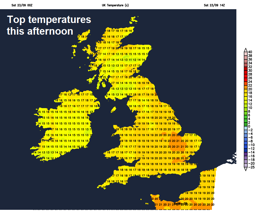
Winds will be coming up from the south today, brisk across the west, but will be bringing up mild air so temperatures reaching 16-18C quite widely, perhaps 19-20C in some spots where we see sunshine for longest this afternoon, most probably across southern England.
This evening and overnight, other than thicker cloud bringing some patchy light rain or drizzle across Scotland, most places will be dry with clear spells spreading up from the south. The exception will be across Ireland, Northern Ireland and western Scotland – where cloud will thicken from the west and outbreaks of rain will arrive through the night. Temperatures generally staying in double figures, so not as chilly as recent nights.
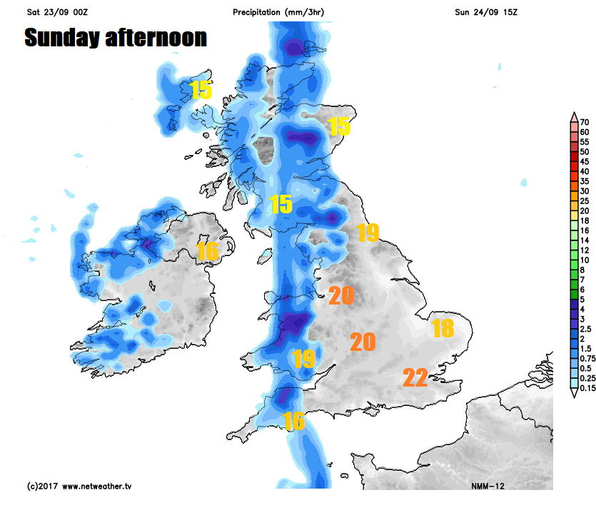
An occluding cold front will grind to a halt across western areas on Sunday, so we will see a band of cloud and outbreaks of rain affecting mostly western Scotland, perhaps Cumbria and west Wales, some uncertainty have far east the rain will reach across Scotland, NW England and Wales though – but it will be cloudy day in these parts nonetheless. Ireland and Northern Ireland turning drier and brighter from the west, though some showers possible. Further east, much of England staying dry, with plenty of sunshine likely across the Midlands, southern and eastern England. Temperatures in the cloudy and damp west reaching 15-17C, but where we see the sun further east reaching 18-22C.
Cloud and rain across the north and west to start early on Monday will gradually edge in across central and southern areas of England, though tending to fizzle out, perhaps no rain reaching parts of East Anglia and far southeast of England, where it may stay bright or sunny. Drier and brighter weather with sunny spells moving in across western Scotland, Ireland, Northern Ireland, Wales and far SW of England. Temperatures reaching 15-19C.
Tuesday is looking mostly dry and fine with sunny spells, warm too in the sunshine, temperatures reaching 17-19C generally, perhaps 20-21C across southern and eastern England. A risk of scattered showers developing across western areas, but they’ll be hit and miss.
Most areas again looking largely dry and fine on Wednesday, warm in the southeast, though cloud increasing from the west, with outbreaks of rain and strengthening southerly winds arriving across Ireland and Northern Ireland through the afternoon before reaching western areas of mainland UK through the evening.
Outbreaks of rain and breezy conditions spreading east on Thursday, clearing eastern England later in the evening, drier and brighter conditions arriving in the far west by early evening. Some uncertainty by Friday, some models paint a drier day, while other models bring more wind and rain back from the southwest.
Spell of wind and rain on Thursday for all parts


