The cyclonic and unsettled weather of recent week is, unfortunately, set to continue.
Issued at 1500BST on Thu 10th August based on Thu 10th August 00Z Model Runs
Key Points
Overview:
The word ‘cyclonic’ continues to be used widely in various forecasts and has been the case for some weeks now. Whether coincidence or not, this summer is showing similarities to that of recent years with unsettled weather often dominant and this due to an unusually robust and S’ly tracking jet stream pattern. At the moment, within the medium and longer term, this trend is forecast to continue. From a meteorological point of view there is now only three weeks, or so, of summer left. Time is indeed running out for any sustained summer weather, especially with regards to this affecting the whole British Isles, rather than just parts of it. There is increasing confidence too for a potentially very unsettled and cyclonic period of weather just after the mid-month period, again directly driven by an active, S’ly track jet stream pattern for the time of year.
Synoptic Discussion:
The 00Z models are in a good agreement as we move into the start of next week for another area of low pressure to move into the British Isles, off the N Atlantic. The overall jet pattern across the N Atlantic, early next week, is more amplified and this does bring a more irregular period of weather. However, the approach of a diffluent trough along with a surface low pressure means that an unsettled start to next week is likely as rain and showers, move N and E. Some heavy precipitation does seem possible, particularly across more N and W areas of the British Isles. The more amplified pattern is exampled well by the 00Z GFS.
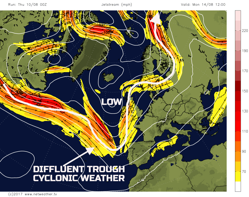
Of note on the above chart though is the continued well organised and particularly powerful jet stream pattern that is exciting out of E Canada, into the N Atlantic. With this pattern and with little sign of any trough extension over the W Atlantic, then, overall, a zonal flow will prevail as next week progresses.
Both Monday and Tuesday are likely to see unsettled conditions dominate, but by late Tuesday a sympathetic ridge may well be moving into some S and W areas of the UK to settle the weather down potentially. However, by the time we get to Wed 16th, the 00Z ECMWF, GFS, GEM and the UKMO model are all in good agreement for a noteworthy jet stream across the N Atlantic. A continued low latitude jet is forecast, of which may well have speeds of up to 150mph or more, indicating an extremely baroclinic environment, one of which is conducive to yet more cyclonic developments. The 00Z GFS model, for the 16th, highlights an N Atlantic pattern that wouldn’t look out of place in October.
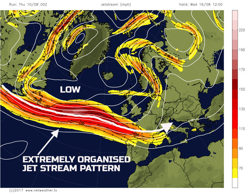
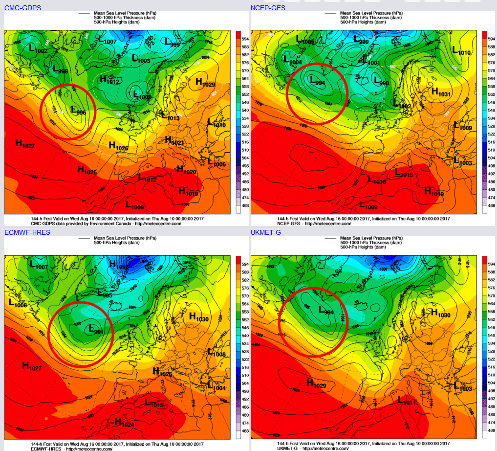
The 00Z models, into the 16th, all have a developing surface low pressure running along the ‘cold side’ of the jet stream, of which could well result in cyclogenesis as it approaches the UK towards the end of the week. Given the time frame involved, there are uncertainties over the track and depth of the low pressure. However, experience tells us that with such a low-latitude and well-organised jet stream pattern than any surface low pressure would likely move directly into the UK, from the W. The GM’s at 0000Z 16th highlight this developing low.
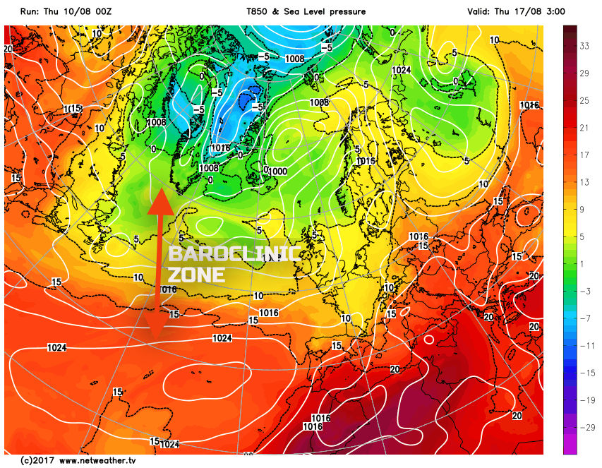
The strength of the jet stream is, among a few reasons, fuelled by a marked baroclinic zone across the N Atlantic. It is the time of year when upper air temperatures, in particular, can start to fall across parts of Greenland, with the -5C 850mb isotherm making an appearance. At the same time heat and humidity is being pumped out of the Eastern Seaboard and into the N Atlantic. This combination creates this sharp temperature gradient or a baroclinic zone. The 00Z GFS highlights this with 850mb temperatures sub +5C just to the S of Greenland, yet just to the E and SW of Newfoundland 850mb temperatures are greater than +15C, a region where low-pressure systems can and will develop.
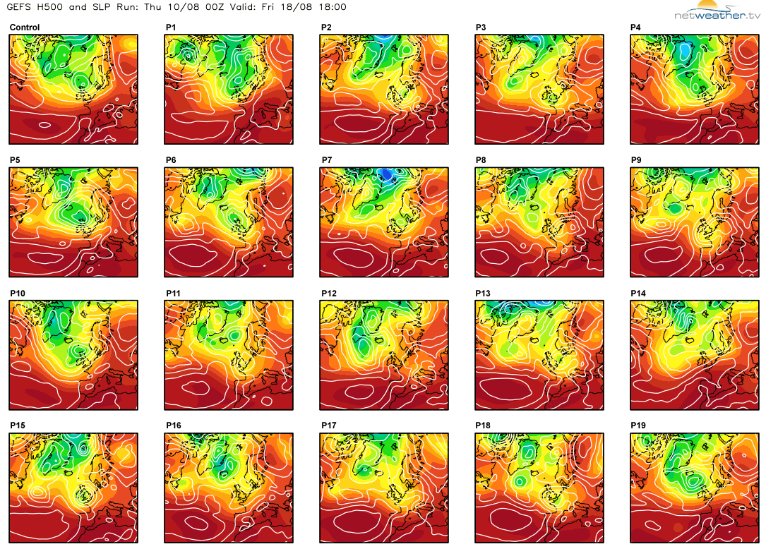
So, looking at the end of next week and all eyes will no doubt surround the development of this low pressure which will approach the UK towards the 17th, 18th and into the weekend of the 19th and the 20th. Inspection of the 00Z EC Clusters does show a real variety in the extent of cyclonic development, but there are some particularly deep low-pressure systems in evidence through the weekend of the 19th and 20th. Whether this level of cyclogenesis does occur is, of course, to be seen, but the potential is certainly there for a very disturbed period of weather just after mid-month. The 00Z GFS Postage Stamps also indicate some deep lows as well, by the 18th, including the Control, P2, P5, P6, P10 and P15, for example.
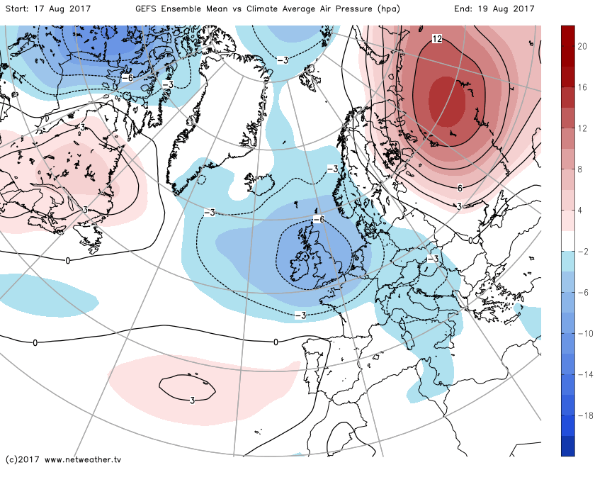
This particular cyclonic period of weather is also highlighted well when using anomaly charts when compared to a climate average. In this instance, the GEFS ENS Mean v the Climate Average Air pressure between the 17th and the 19th has a pronounced negative anomaly across the British Isles and NW Europe.

So, this period of unsettled and cyclonic weather takes us to and comfortably beyond the middle of August. There are, of course, uncertainties over the details of any cyclonic weather, but the outlook, through until the week beginning Monday 21st is an unsettled one. Those hoping for a mid-month change to warmer, drier and more settled conditions will, more than likely, be disappointed. Given the cyclonic pattern then some severe weather seems possible, perhaps due to rain or potentially unseasonably high winds too.
Long Term (21st to 31st Aug)
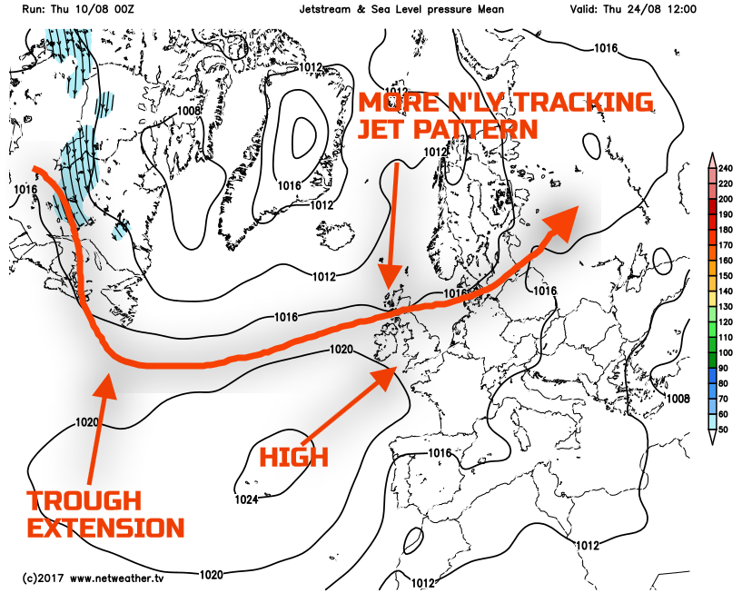
As we look through to the final week or so of August and, at the moment at least, there isn’t any real evidence to suggest that the overall unsettled regime will change. Clearly, at this time frame, there is always the possibility of change that is the nature of meteorology. However, analysing the longer range GEFS, EC EPS and the EC Monthly forecasts, the output is for further unsettled conditions, perhaps especially across more N and W areas. There is, however, some evidence that the pattern may become more amplified towards the end of the month. Trough-extension over the far W of the N Atlantic may occur and perhaps lead to a greater risk of the Azores high extending N and E into at least S and E England, which would also potentially signal a more N’ly tracking jet stream pattern. However, there continues to be little evidence for any substantial, anticyclonic weather across the whole of the British Isles.
If however, we do get to the end of August without any nation-wide settled weather then, no doubt, August will end up being a particularly poor summer month, especially regionally and would follow a rather disappointing July, for many areas too. Some areas will likely see above average rainfall totals and below average temperatures, especially if the run of chilly nights continues as well. It may well be a case of looking even further head and hoping for some settled and warm weather in September, of which is certainly possible and of which has occurred in recent years after poor summer weather. We’ll keep an eye on that potential in the coming weeks.