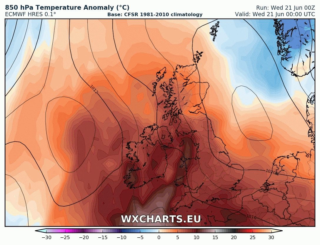
Very hot for the south today, 30C widespread, perhaps 34C in London. Last day of the heatwave, as cooler, fresher and more changeable conditions take over by Friday, thunderstorms during this transition.
Tuesday saw 30C quite widely across southern Britain, and today on summer solstice could be the hottest day of the day of the year so far, with 33 or even 34C not out the question somewhere across SE England. But today also the last day likely to see 30C or more, as the heatwave breaks down from the west by the end of Thursday, with heavy rain or thunderstorms for some during this transition to cooler and fresher conditions from the west. After Thursday the weather will become cooler, changeable and often breezy for all, northern areas seeing the greatest chance of rain, southern areas drier and sunnier, but most will see some rain at some point.
It was another warm and muggy night across southern and western parts of the UK, particularly across Wales and SW England – where temperatures fell no lower than 18-20C in some spots. Somewhat cooler conditions across Scotland, northern and eastern England – with a fresh easterly breeze across eastern England. Much of England and Wales has remained dry again overnight, but across the far north of England we’ve seen thunderstorms develop and move northeast since around 4am, with some showery rain also spreading northeast across southern Scotland, north Wales, parts of Northern Ireland and the Republic of Ireland in the early hours.
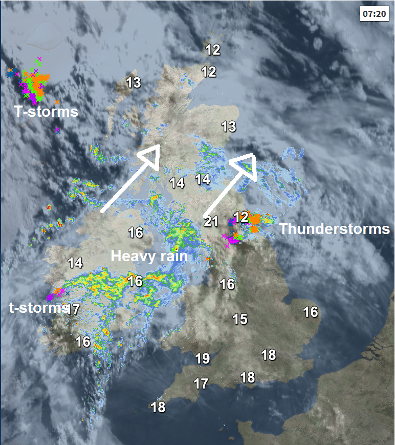
To the south of the storms ongoing across the far north of England, there is some mist or low cloud in places to start the morning, but for much of England and Wales it will be another hot and humid day, best of the sunshine across southern, central and eastern England, always more in the way of cloud across Wales and northern England, early storms across the far north of England clearing this morning, but we will likely see further thunderstorms develop across north Wales, northern England and perhaps further south into the north Midlands and Lincolnshire through the afternoon and into the early evening. Some of these storms maybe capable of producing severe weather too, given a very unstable atmosphere in place across England and Wales today, for more on this please read the Netweather Storm Forecast.
Scotland and Northern Ireland will be cloudy for much of the day and will see pulses of heavy rain and embedded thunderstorms work their way northeast, perhaps a few of those stronger storms across northern England affecting the Scottish borders. Cooler and fresher here too.
A very hot day across central, southern and eastern England along with east Wales – where temperatures will climb to 30-32C quite widely, perhaps reaching 34C in London, which will make it the hottest June day since 1976. It will be cooler around coasts – where there will be onshore breezes. A cooler and fresher 16-19C across Scotland, perhaps 22C in N. Ireland where the sun pops out.
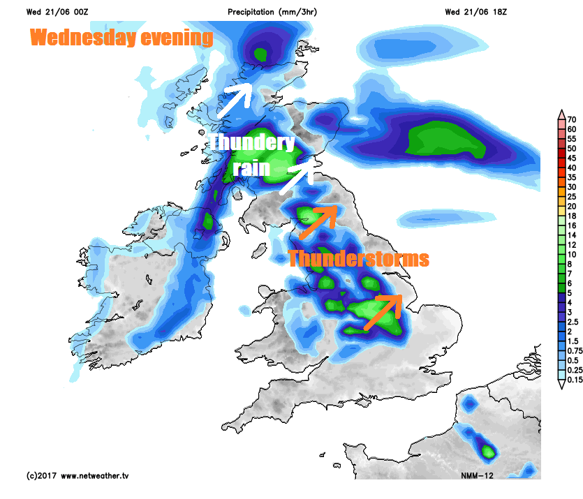
Through this evening and overnight, outbreaks of rain or thunderstorms across the north, perhaps severe across northern England and the Scottish Borders, eventually clearing out into the North Sea. Then becoming dry across many areas for a time, very warm and muggy across central and eastern England. However, further thundery downpours will develop and move in along a cold front across Wales initially in the early hours then across NW England down into the Midlands by 6am Thursday morning.
Then on Thursday morning, a line of storms or heavy rain along a cold front stretching from northern England down towards central southern England by breakfast time will spread to areas further east during the morning, some of the storms could be severe, with a risk of large hail, flash flooding and damaging wind gusts. Cooler and much fresher but brighter and drier conditions across Scotland, N. Ireland, Wales and SW England in the morning spreading to all parts into the afternoon following the band of storms. Turning cloudier with outbreaks of rain arriving across the far northwest during the evening. Temperatures still reaching 24-26C across SE England and East Anglia, but elsewhere 16-20C more likely the highs.
Heat finally subsiding across the southeast on Friday to join all parts to cooler and fresher feel. Cloud and outbreaks of rain arriving across Scotland Thursday night into Friday morning spreading southeast towards Wales and the Midlands by early evening, weakening as it does so, brighter and drier conditions following. Southeast England probably staying dry and bright. Temperature still perhaps reaching 24C in London, but elsewhere 16-21C more likely the highs.
Saturday and Sunday, at the moment, are looking breezy – especially in the north, many will be bright or sunny, though there will be some scattered showers likely across northern and western areas. Temperatures reaching 14-17C across the north, 18-22C in the south.