Issued at 1500BST on Tue 4th April based on Tue 4th April 00Z Model Runs
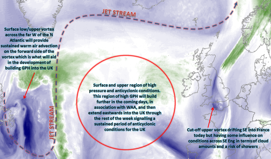
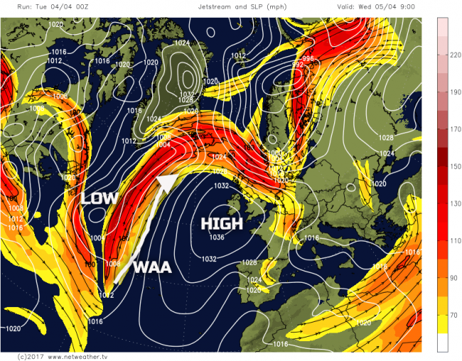
Wed 5th to Fri 7th Apr: The coming few days can be grouped together, primarily due to the fact that the broader synoptic evolution is one towards increasing GPH across the whole of the UK as WAA within the W Atlantic, in association with an upper vortex, allows for high pressure to develop across the UK. The second half of the week, as a result will overall produce anticyclonic conditions for many areas of the UK and with some particularly quiet and benign weather conditions for many. The evolution into Wednesday, which will dictate the weather through the rest of the week, is associated with developments upstream, across the N Atlantic. An upper vortex and surface low pressure just to the east of Newfoundland is producing sustained amounts of WAA on the western flank of a surface high pressure situated just to the SW of the UK. This development, amongst other factors, will lead to a steady build of GPH across the UK, from the SW. The 00Z GFS model, for early Wednesday, highlights this well, noting the surface low and the surface high being discussed.
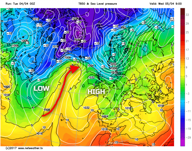
When WAA occurs on the western flank of an area of high pressure it often (not always) signals a rise in GPH and a steady build of pressure. This is what is expected to take place across NW Europe and over the UK through the rest of the week. The GFS model, using 850mb temperatures, highlights this WAA on the western flank of the high pressure well. Clearly, this is just one specific level regarding temperatures for example, but the overall setup highlights WAA.
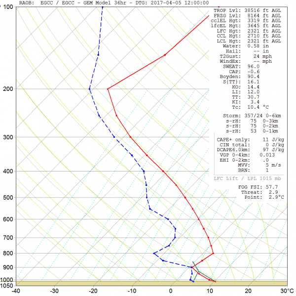
So, the actual weather throughout the second half of the coming week will be dominated by this process of WAA allowing for GPH to increase and with then a steady build of pressure across all areas of the UK. The initial process, on Wednesday, is likely to lead to quite cloudy conditions, though. The position of the high pressure, still generally to the SW of the UK, means that a relatively moist air mass will move over the top of the high pressure and down into the UK. In fact, the 00Z UKMO FAX for 12Z Wed 5th does have some weak occlusion/warm front moving down into the UK, essentially representing a greater propensity of cloud within the NW’ly flow over the top of the high pressure. As a result, a rather cloudy and cool day is expected on Wednesday with some light showers possible in the north and the cloud perhaps thick enough elsewhere for some patchy light rain and drizzle. There will still be some cloud breaks, with some brighter intervals, but a lot of cloud is to be expected.
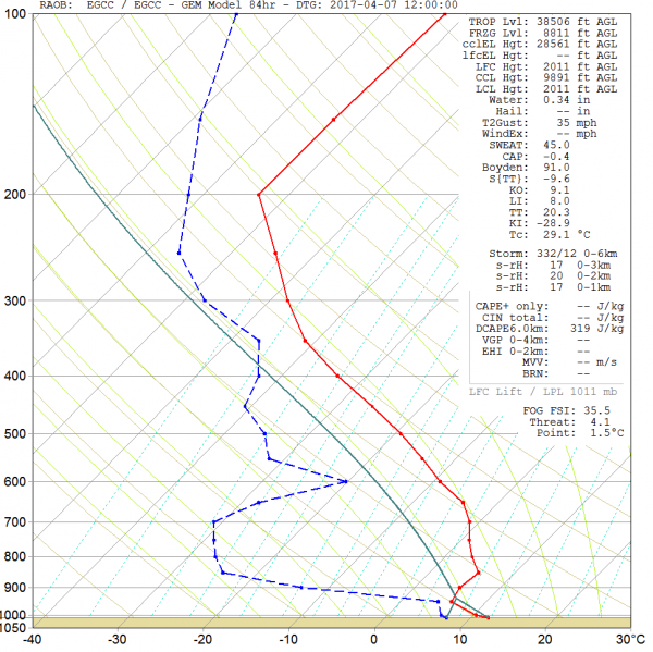
This is exampled well by the forecast sounding for Manchester, below, through the middle of the day. The forecasted profile within the lower layers, especially near 900mb is almost completely saturated, again highlighting a lot of ScCu type cloud. Equally, as though the upper levels of the atmosphere, especially 400mb and above, are also likely to see quite a lot of cloud as well.
As we progress into Thursday and Friday though, the high pressure will begin to drift eastwards with the CoG (Centre of Gravity) of the high pressure likely to be across parts of SW England and Ireland both on Thursday and Friday. This will lead to an increasing amount of subsidence within the atmosphere and also help to ‘cut off’ the NW’ly flow, especially across England and Wales by Friday. As a result, despite some uncertainties, especially locally and regionally, cloud breaks are likely to become more extensive through the end of the week. As a result, both Thursday and Friday will be predominantly dry across many areas of the UK with increasing amounts of bright or sunny spells, these locally prolonged at times, especially across more southern and western England and Wales. Cloud may well still be thick enough across the far north and west of Scotland for some light precipitation, seeing this region of the UK will be on the northern periphery of the anticyclone, but the emphasis is on a very quiet and benign period of weather.
Looking at another forecast sounding for Friday, the 7th, and again for Manchester, you can clearly see a marked difference in the overall atmospheric profile than compared with the one looked at for Wednesday. There is a marked region of dry air from around 900mb and above, with a very dry looking profile between 900mb and 700mb in particular, this directly associated with subsidence in conjunction with the anticyclone. Some fair weather, shallow, Cu clouds may well still be possible, but compared with Wednesday this is a far drier profile. Of which, again, leads to the prediction that both Thursday and Friday will steadily see more in the way of cloud breaks, more sunshine and it then beginning to feel warmer as well. Nights, however, will still be chilly but nothing untoward is expected for early April.
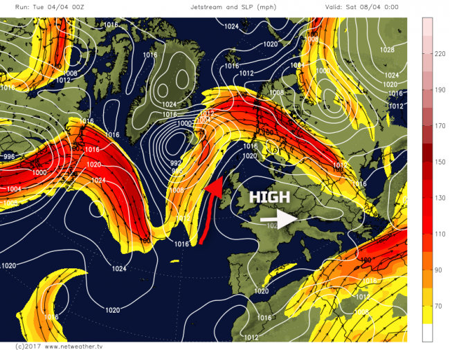
Sat 8th and Sun 9th Apr: So, we move into the coming weekend, and we have high pressure dominating the weather across the UK with the jet stream tracking to the N of the UK. There will be some mobility trying to exert itself across the N Atlantic, and this will eventually lead to a breakdown to more unsettled weather, but more on that within the medium and longer term section. The main feature of interest with the coming weekend is that the high pressure will begin to decline away to the E of the UK, with time, and this will allow for a feed of higher WBPT and 850’s from the S and SW across the UK. This will naturally lead to higher temperatures but when combined with the ever-increasingly-strong early April sunshine will mean quite a quick increase in temperatures this weekend with it becoming warm or, more locally, very warm.
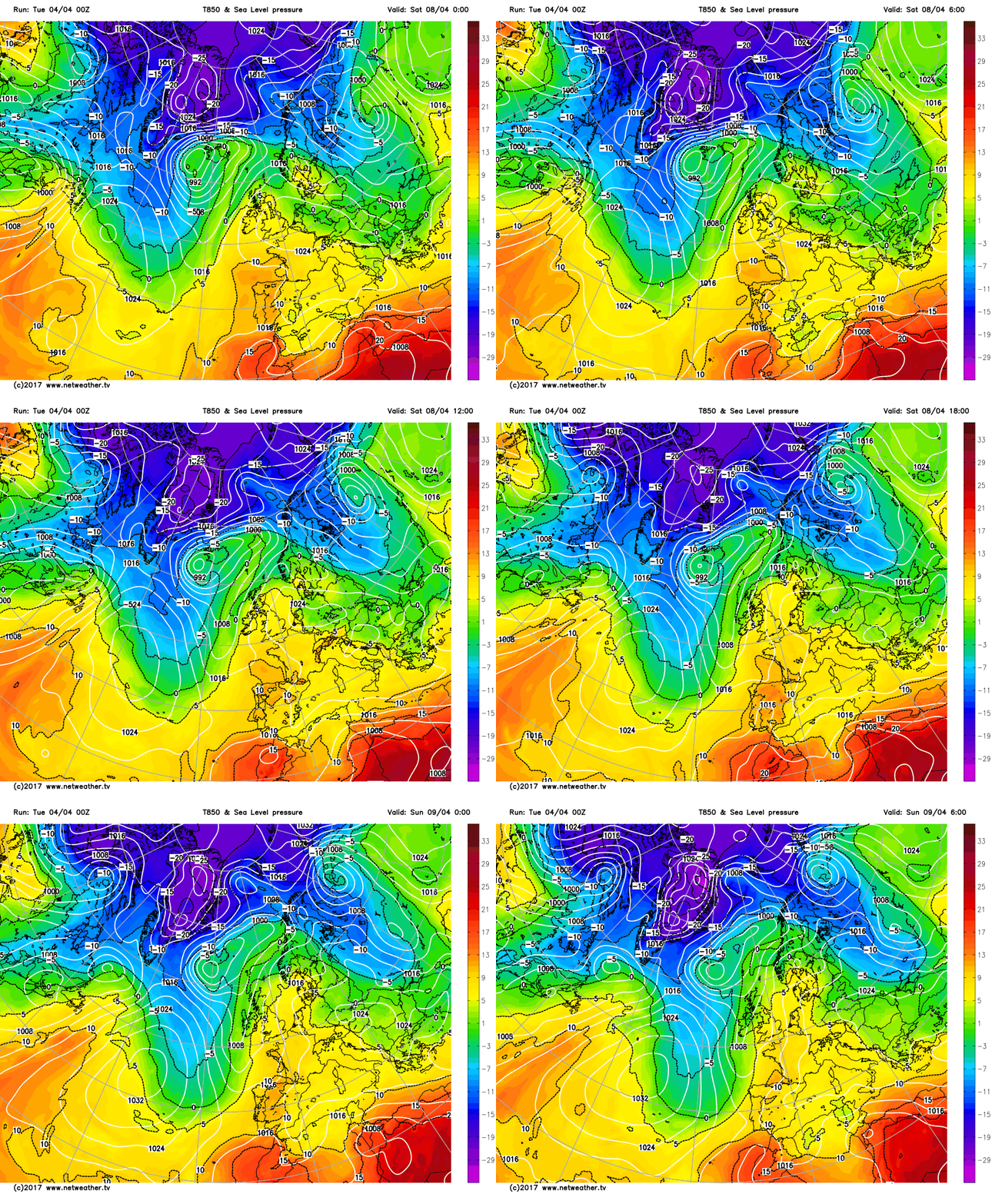
This advection of a warmer air mass into the UK is highlighted reasonably well by the GFS model, noting the yellow shadings heading up into the UK from the S and SW through the course of Saturday.
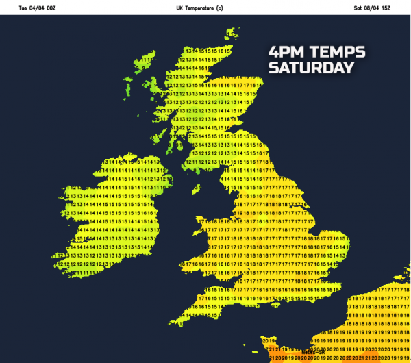
So, the overall expected weather for the weekend is good, especially across England and Wales. Many areas will be dry on Saturday with bright or sunny spells and with the increasingly warmer air mass filtering into the UK then temperatures will respond, with a very pleasant Saturday afternoon likely across many areas, but especially across England and Wales. By the time we get to Sunday, there may well be an attempted breakdown from the west with a frontal zone bringing some rain and cloudier conditions to parts of Scotland and Ireland, but this is a very uncertain development for now. Even if this does occur most of England and Wales will likely hang on to warm dry and relatively sunny conditions. Our MR weather model highlights the currently expected temperatures for Saturday afternoon and, as can be seen, many areas of the UK will have temperatures in the mid-to-high teens and when coupled with some sunshine will feel very pleasant indeed.
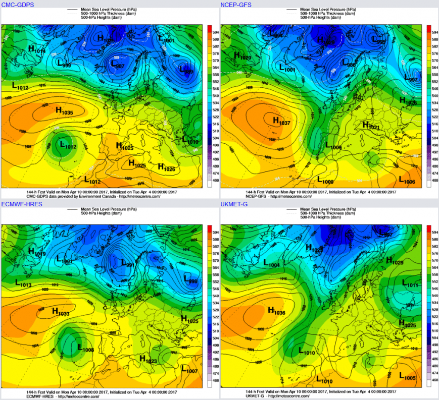
From approximately the 10th onwards a breakdown to more unsettled conditions is then expected. This has been quite a consistent signal now from all the main GM’s and ENS that the approach to mid-month will produce far cooler and more cyclonic conditions. The 00z UKMO, ECMWF, GEM and GFS all highlight this taking place on Monday the 10th with the high pressure declining into Continental Europe and with then a greater signal for more of a mobile pattern developing. With falling GPH and a subsequent risk of rain and showers, especially across the N and W of the UK. There are uncertainties over how rainfall will develop from this setup, but the period from the 10th through to mid-month is likely to be very different to the coming days, with the combination of more unsettled conditions combining with lower temperatures to create a very different ‘feel’ to the weather. April can often be a month of varying conditions with one week providing some spring-like conditions, but the next feeling more like late winter and that general evolution may well take place over the next 7 to 14 days.
Loading recent activity...