


The second synoptic guidance update in the series, looking at the forecasting model outlooks over the coming week.
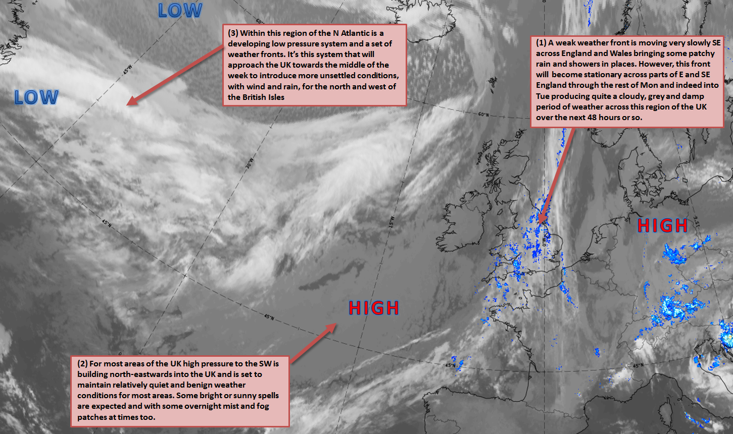
Mon 19th: Forecast model agreement is good regarding the synoptic developments through the remainder of Monday with the main GM’s (UKMO, GEM, GFS and ECMWF) all highlighting an increasingly slow moving frontal zone to become situated across parts of the Midlands, S England and E England through the rest of the day. The frontal zone was more active overnight in direction association with an upper trough, but this is clearing away and generally pressure across the UK is relatively high with subsidence taking place. This, as a result, means that most of the precipitation associated with the frontal zone across parts of southern and eastern England will become increasingly light and patchy, but with some moderate bursts remaining possible for a time. Elsewhere with the exception of a few showers across the far west and north-west of the British Isles the remainder of Monday is set fair with bright or sunny spells but often variable amounts of cloud. Forecast soundings highlight some extensive cumulus and stratocumulus at times and this places emphasis on cloudier periods rather than any prolonged spells of sunshine.
Tue 20th: Into Tuesday and the main jet stream remains to the north-west of the UK with still relatively high GPH (geopotential heights) across the UK. The weak frontal zone from Monday is, however, still signalled to be in evidence by most of the global and higher resolution models across some eastern and south-eastern areas of England. As a result another relatively cloudy and damp day is expected here but the precipitation by this point really becoming increasingly fragmented. The remainder of the UK sees a similar synoptic pattern to Monday with atmospheric pressure set to be around or just above 1020mb. Forecast profiles highlight further bright or sunny spells but with some convective infill likely during the day in the form of cumulus and stratocumulus. It should be highlighted too that some mist and fog may well develop beneath the ridge axis into Tuesday morning across some parts of S Scotland, N England and Wales. Whilst predominantly benign conditions exist across the UK developments up-stream are important through Tuesday with an upper trough extending out of the Greenland region and a surface low pressure then develops to the west of the UK as the day progresses.
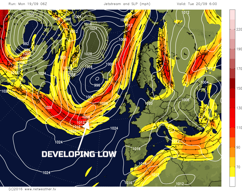
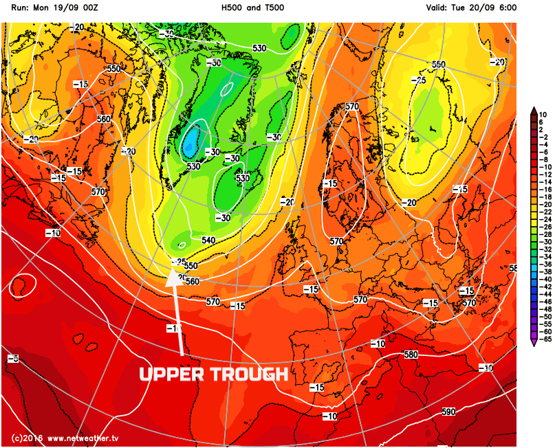
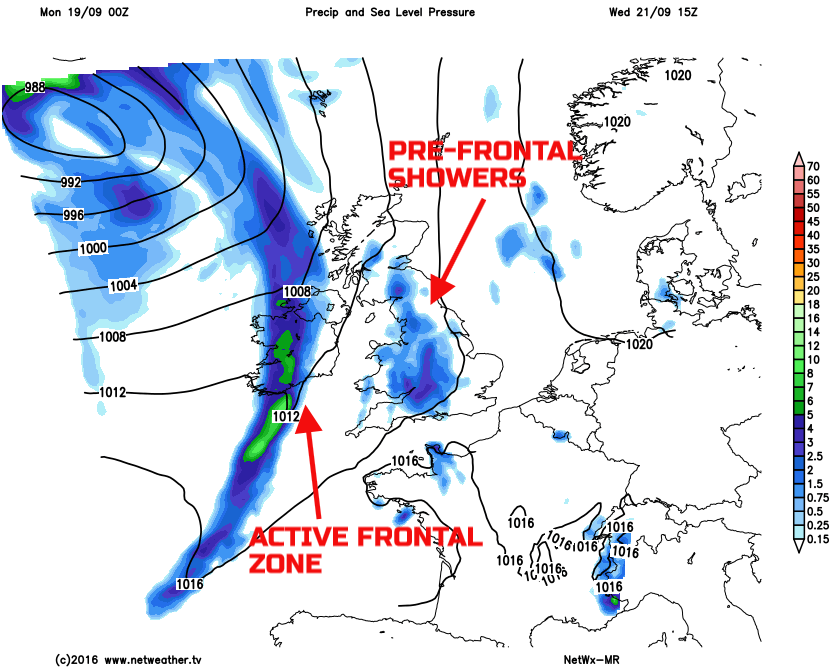
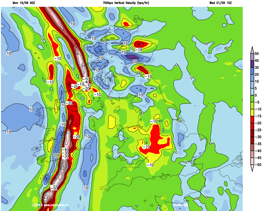
Weds 21st: Into Wednesday and the UKMO, GFS, GEM, ARPEGE, JMA and ECMWF are all in broad agreement for a developing area of low pressure with a central pressure around 990mb to 995mb to be in evidence to the west of the UK. The surface low pressure is expected to develop due to the interaction with the upper trough and the jet stream. Conditions ahead of the low pressure, essentially across many central, southern and eastern areas of England remain relatively quiet and benign. Forecast soundings do show some increase in instability so perhaps with a greater risk of showers developing through the day. However, the main change will be across Scotland and Ireland as a cold front, associated with the developing low pressure, moves into northern and western areas of the British Isles through the day. There is likely to be an increased pressure gradient associated with the low, so a developing fresh or strong S’ly wind is expected too.
Initially, at least, the front zone looks well forced (as exampled by the 700hpa vertical velocity chart) and, as a result, some moderate or heavy rain is expected across Scotland and Ireland as the day progresses, perhaps with some pre-frontal showers too. The main region of frontal precipitation is then expected to move into N England and Wales, perhaps SW England too, during the middle and latter half of the day but by this time the main upper trough will be easing away and the forcing associated with the front will be less and hence a general reduction in the intensity of the frontal precipitation is expected as the day progresses.
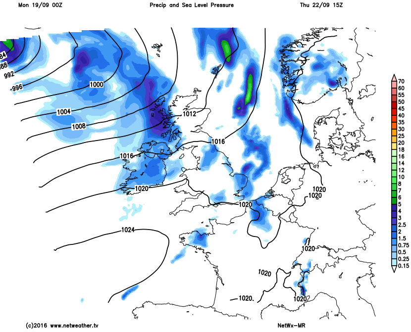
Thu 22nd and Fri 23rd: The evolution towards the end of the week has changed somewhat over the last 24 hours to more of a cyclonic outlook, particularly on Thursday across the north and west. The parent low that brings the wet weather on Wednesday into the north and west of the UK then becomes a dominant feature to the north-west of the UK. At the moment the GFS, UKMO, GEM and the ECMWF have a more pronounced upper trough moving into northern and western areas. As a result a mixture of sunshine and showers looks likely across Scotland, Ireland and perhaps Wales and N England. Instability is expected to be greatest though across Scotland and Ireland where moderate or heavy showers are possible from towering cumulus or cumulonimbus development, as is in evidence in some forecast soundings. The cold front from Wednesday is signalled to be across SE England early on Thursday but as a weak feature, so this generally insignificant. This signal for showery conditions on Thursday is exampled on the image below and then by Friday there is reasonable model agreement for trough extensive to take place within the North Atlantic. This process, as a result, signals some WAA (warm air advection) downstream towards the UK but allows for a rise in GPH and hence Friday across England and Wales, at least, looks like being a fine and settled day with some sunshine, but with perhaps frontal systems passing close enough to W Scotland and Ireland to bring frontal rain here.
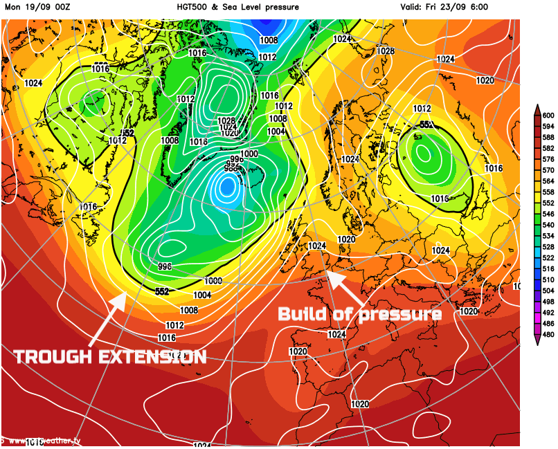
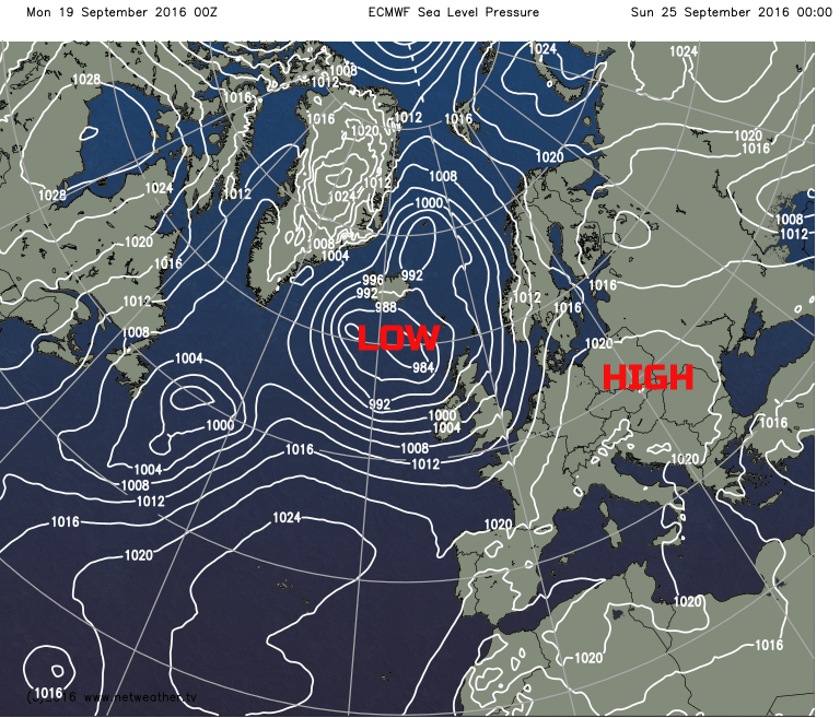
Sat 17th and Sun 18th Outlook: Into Saturday 17th and the build pressure that develops at the end of the week is currently set to maintain a fine start to the weekend across England and Wales. The GEM, GFS, UKMO and ECMWF are all in generally good agreement regarding this. However, a more cyclonic SW’ly air flow is likely across Scotland and Ireland on Saturday with frontal rain likely. As the weekend progresses, whilst there is some uncertainty, the majority of the models, including ENS data, show the ridge and surface high pressure declining into the near continent as a more cyclonic flow develops more widely over the UK. This progression towards a more cyclonic pattern nationwide is exampled well by the 00Z ECMWF into next Sunday the 18th.
Temperatures through the coming week will be far nearer to climate averages after a very warm first half to September indeed. 850mb temperatures are set to range between +3C and +8C as a range through the week with maximum temperatures across the UK ranging between 13C and 20C, always highest across S England, coolest across Scotland, Ireland and N England. Some cooler nights are likely to be maintained as well with some chilly nights, rurally at least, across Scotland and N England at times, especially up to the middle of the week before the stronger winds develop.


