
A look at what was the driver behind the severe storms and heavy rain that have brought misery to parts of mainland northern Europe since Saturday.
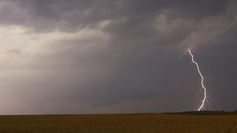
Severe weather over northern Europe over weekend has certainly made the headlines over the last few days, as intense thunderstorms have caused injuries from lightning, along with severe flooding and damage from large hail in places.
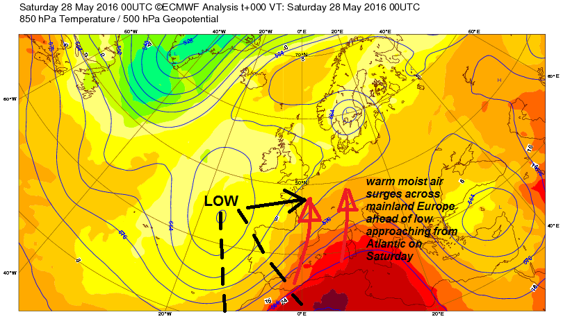
The trouble started late last week, as warm and moist air built up over central and southern France ahead of an upper low over the Bay of Biscay. As the low begun to eject eastwards across France on Saturday, it introduced colder air and stronger winds aloft while creating forced ascent of the warm and humid air present – which allowed the rapid development severe thunderstorms across much of France during Saturday afternoon – bringing frequent lightning, large hail and flash flooding. Widespread storms, some severe, developed further east across southern Germany, Switzerland, northern Italy and Austria too. The storms were most severe across France on Saturday – where not only was there injuries caused by lightning in Paris and the tragic death of a young girl by flooding in Burgundy, but also large hail caused damage to or destroyed thousands of hectares of vineyards across central and western parts of France, including the famous Cognac and Chablis growing regions.
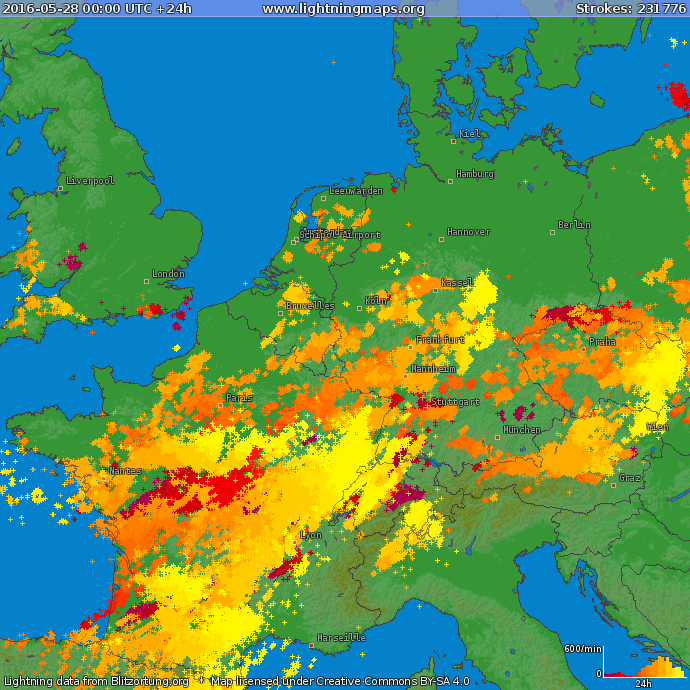
Lightning strikes over Europe on Saturday, particularly numerous over France - where 73,000 strikes were recorded.
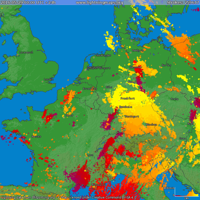
Widespread thunderstorms carried on overnight or re-developed into Sunday across southern Germany, The Alps, northern Italy and into Poland, Czech Republic and Hungary – as the low pressure moved across France into the Low Countries with a plume of warm moist air surging NE and destabilising ahead of it. Severe storms brought flash floods to parts of southern Germany, leaving 4 people dead and several injured, More storms developed over France too, but more scattered and isolated.
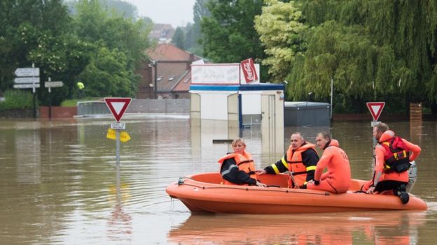
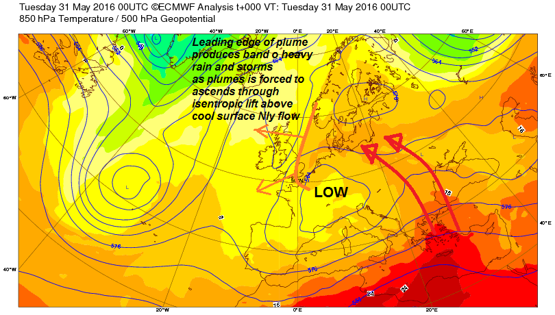
Then on Monday, the upper low moving east over France at the weekend ground to a halt to be centred over NE France/SW Germany, thanks to blocking high pressure over Scandinavia and the Baltic Sea. Meanwhile, a surface low rotated N the NW across Germany and toward the Netherlands on the eastern and NE flank of the upper low. Slow-moving fronts wrapping around this low brought hours of persistent and heavy rain to northern France, leading to flooding of properties and disruption to transport. People had to rescued from properties in a few towns in northern France when water levels rose above a metre. In Paris, the River Seine rose by 3 and-a-half metres, levels only normally seen during some winter. The French Open tennis tournament at Roland Garros, in Paris suffered its first wash out since 2000 as the rain meant no play was possible at all. The situation barely improved yesterday, as the rain returned to cut matches short. France’s equivalent to the UK Met Office, Météo France, has Orange alert weather warning, the second highest alert level, remaining in place for 23 départements in central and northern France until Wednesday morning at least, with more heavy rain forecast.The alerts will remain in place until Wednesday morning but could yet be extended given the forecast is for more rain throughout the week.
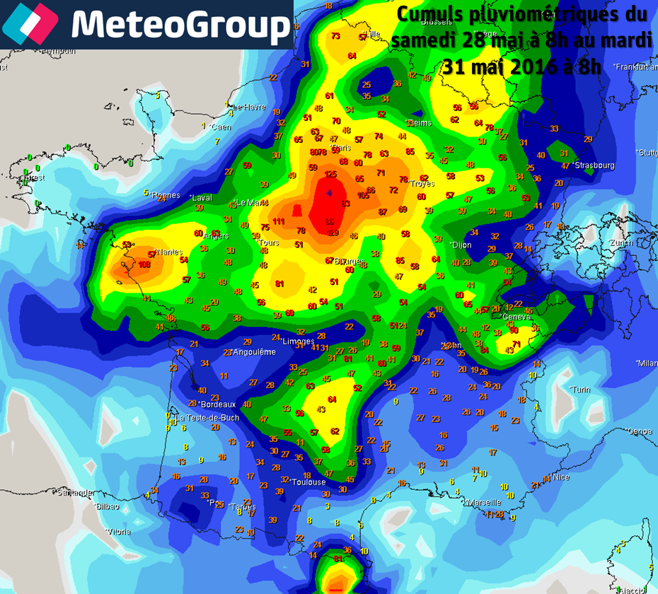
Rainfall accumulated over France between Sat 28th 08z and Tuesday 31st 08z (image courtesy of Meteogroup)
Further NE, the moist plume rotating around the eastern and northern side of this low spread N then W across Poland, northern Germany, Denmark and reaching the Netherlands Monday evening. The leading edge of the plume producing widespread and intense thunderstorms with frequent lightning as it surged west across northern mainland Europe. These storms spread west across the North Sea Monday night, bringing a band of heavy and persistent thundery rain to East Anglia and SE England yesterday morning, brinigng 53.4mm (a month's worth of rain) at Wattisham in Norfolk, though lightning from this system was confined to Norfolk and Suffolk before fading through the morning as destabilisation weakens.
.png)
Low pressure looks to be stuck across N France, Benelux and Germany for much of the rest of the week, so further rain, showers or thunderstorms for these areas and much of central Europe. A frontal system that is currently pushing west across England today from this low pressure system looks to grind to halt over the next few days too, bringing cloudy skies and further rain, though increasingly light and patchy, on Wednesday and Thursday across England and Wales. Drier and sunnier weather returning to Wales and western parts of England on Friday as high pressure builds down from the NW. Those holidaying for half-term this week should head to western Scotland, Ireland and N. Ireland for the best chance of staying dry and seeing some decent sunshine!


