


A look at the weather across mainland Europe over the coming week.

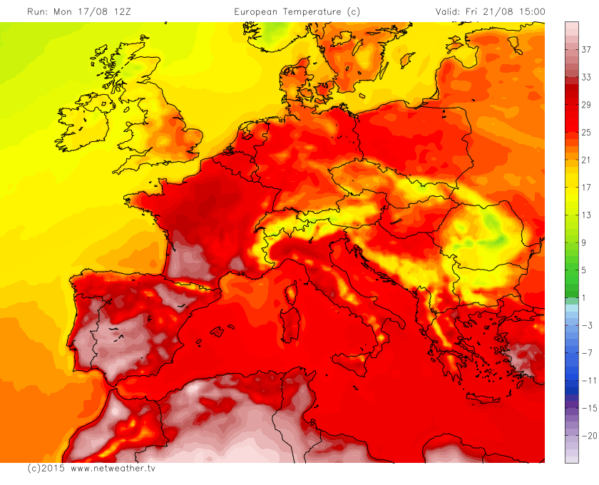
A prolonged heatwave that has gripped much of mainland Europe since early June, with triple digit temperatures recorded as far north as Poland and northern Germany earlier this month, has finally eased over the weekend.
A persistent ridge of high pressure over central and eastern Europe saw the unrelenting heat continue here through much of last week, following all-time records broken in Poland the previous weekend, with Wroclaw setting an all-time high record temperature of 38.9C (102F) on the 8th and Kitzigen in Germany soaring to 40.3C (104.5F) on the 7th, tying with the all-time record on the 5th July. Poland's national energy supplier even had to reduce electricity supplies to factories as rivers, which cool power plants, were running critically low due to drought and the severe heat. But the recent heat across central and eastern Europe eases this week.
France warms up during the week, after a cool start to the week away from the SE, cooler and unsettled conditions return to western France this weekend. Spain, Portugal, Greece and Turkey remain mostly dry and hot, though not the intense heat as earlier this month and through much of July. Italy, again, not as hot as recent weeks, with a risk of storms mid-week, but otherwise mostly sunny and very warm in the north to hot in the south.
Central and eastern Europe this week
Last Thursday saw triple digit temperatures across eastern Austria, western Slovakia, Hungary and Croatia. But the persistent ridge of high pressure that brought the record heat to central and eastern Europe has slipped away over the weekend to be replaced by a trough moving in from western Europe, with a cold front moving east across Germany bringing cooler temperatures from the west here. The front has struggled to make much progress further east into Poland and other eastern Europe countries, where we will hang onto to very warm conditions this week, but at least it won't be so hot here, with temperatures reaching 28-30C, and we will see some showers or thunderstorms across southern Poland, Slovakia, Hungary and on into Romania over the next few days at least. The slow-moving front that moved into central Europe over the last few days will bring cloud, persistent rain and much cooler temperatures across central and parts of northern Germany, Czech and Slovak Republics before it eventually fizzles out on Wednesday. Temperatures reaching the high teens at best under the cloud and rain. Though the far northeast of Germany including Berlin will retain some sun and heat with with highs of 28-30C still possible here. Switzerland, Austria and southern Germany cool and showery but with sunny spells until mid-week, temperatures reaching high teens or low 20s.
Slow-moving frontal boundary bringing rain across Germany into central Europe until later in the week divides cooler air to the west and hot air to the east, high pressure over Scandinavia then builds south to bring a drier end to the week:
High pressure then builds down from Scandinavia from mid-week, with drier and increasingly warmer conditions returning to Germany, Austria and much of eastern Europe for the rest of the week and over the weekend, temperatures recovering to the mid to high 20s.
France
For France, for the first half of this week temperatures will be close to or slightly below average for late August, thanks to the airmass coming in off the Atlantic, temperatures reaching 20-23C generally, 25-29C towards SE France. It will be mostly dry too, though some showers or storms are possible over central parts. From mid-week, remaining mostly dry and sunny with temperatures on the rise, so by Friday reaching 29C-30C inland across the north and west to 30-32C across central, southern and eastern parts. Always cooler across Brittany and Normandy where temperatures of low to mid 20s are more likely. Cooling off at the weekend across western France, as Atlantic fronts spread cooler air with outbreaks of rain, showers or storms in from the west. Hot and dry conditons becoming confined to eastern France.
Heat builds across France and Spain towards the end of the week:
Spain and Portugal
Not the same level of heat to start the week as we've seen earlier in the month and indeed since the start of summer, but nonetheless some hot, dry and sunny conditions prevailing across southern and eastern Portugal, central and southern Spain, with temperatures until mid-week reaching 34-36C inland across southern Spain, 29-31C along the Costas of southern and eastern Spain along with the Balearics. Northern Spain cooler with temperatures in the low to mid 20s and a risk of showers or thunderstorms on Tuesday in the northeast towards Barcelona and also along the north Atlantic coast, otherwise mostly dry. Portugal seeing temperatures of low to mid 20s across northern and western areas until mid-week, with a risk of showers in the NW region on Tuesday, otherwise dry and sunny. Algarve and eastern Portugal high 20s into low 30s.
Heat builds across much of Spain and interior Portugal from mid-week, as we see an upper ridge build north out of NW Africa, temperatures reaching 35-37C over interior parts of Spain, 32-34C over eastern Portugal. still 29-31C over the Costas of eastern and southern Spain and the Balearics, 24-29C across western Portugal and the Algarve. A more comfortable 23-25C over northern Atlantic areas of Spain to 26-27C over NE Spain. Heat easing off across northern Spain and Portugal over the weekend, with a few storms possible in the north, remaining hot and dry across central, southern and eastern Spain including the Balearics.
Italy and The Balkans
Other than some heavy showers or thunderstorms across the Alps, Italy mostly dry, sunny and very warm or hot, temperatures 26-30C, until mid-week, when it looks to turn more unsettled, as a trough moves in from the NW. Wednesday seeing sunny spells and scattered heavy showers or thunderstorms, with highs of low to mid 20s, though the far south of Italy and Sicily remaining hot and dry with highs of 30-32C. Dry and sunny across most of Italy on Thursday, Friday and the weekend, highs of 26-29C, perhaps 31C in Sicily.
Unsettled mid-week across Italy, then The Balkans later in the week as a trough moves east, turning drier from the west again:
The Balkan countries very warm or hot and sunny with temps in the mid-high 20s in northern parts, to low 30s across Albania, Macedonia and Bulgaria, though scattered showers or storms Monday and Tuesday. Drier on Wednesday and warmer too, but showers or storms return across northern and western Balkans on Thursday before transferring east into Romania and Bulgaria on Friday while it turns drier across the western Balkans to end the week and into the weekend. Always hotter the further south you are in the Balkans.
Greece and Turkey
Other than a few storms over northern Greece, mostly hot, sunny and dry across Greece and Turkey this week and into the weekend, temperatures in the low 30s across Greece and Northern Turkey, mid to high 30s across southern Turkey.


