Latest short to medium range outlook - 40 days of rain won't happen as per St Swithin's legend, but it's a changeable outlook for the second half of July.
It's St Swithin's Day and it was a soggy start across southern and eastern parts, so if you believe the myth that if it rains on Saint Swithun's day, 15 July, it will rain for 40 days.
St Swithun's day if thou dost rain
For forty days it will remain
St Swithun's day if thou be fair
For forty days 'twill rain nae mare
However, you'll be glad to know that observational evidence from weather records going back over many years suggests there's no truth in this myth. What we are looking at is a mixed and changeable picture for the second half of July. Some dry, warm and sunny days, but also some days with rain or showers. We keep some reasonable warmth in the short-term, with a very warm day for the south on Thursday and staying pleasantly warm in the south next week. Though there are hints that it may turn cooler towards the last week of July, as southerly or southwesterly winds are replaced by northwesterly or even northerly winds.
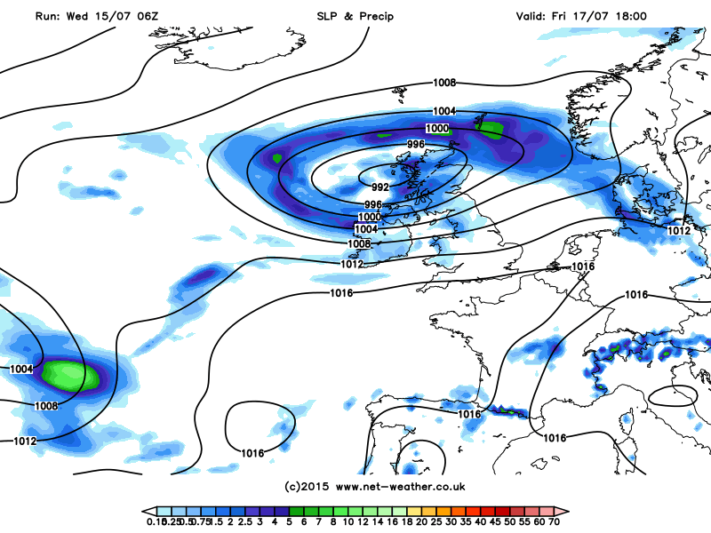
Deep low arriving in the far west and its cold front breaks down some brief heat arriving in the south on Thursday:
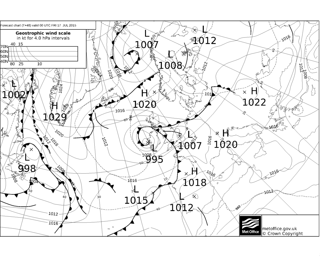
Over the next few days, an unusually deep low for July will rapidly develop as it moves northeast across western Ireland later Thursday before ending up parked over Scotland as the weekend starts. Ahead of the this deepening low moving up the western side of the British Isles, a warm and humid airmass will spread north across England and Wales Thursday afternoon and evening behind a warm front lifting north. The warm front bringing some mist and low cloud with but skies brightening from the south and turning very warm or hot across southern England. This 'plume' of very warm air will be brief though, as that low arrives from the SW across the far west introducing cloud and outbreaks of thundery rain across Ireland and Northern Ireland during the day, reaching SW Scotland by evening. A cold front associated with the low and instability ahead of it will trigger some lively thundery downpours across England and Wales later Thursday evening and overnight too, before moving northeast into the North Sea and reaching Scotland Friday morning. The cold front introducing fresher and windier conditions for Friday behind it for all areas. The thunderstorms will be hit and miss, so not everywhere will see one.
Then on Friday, it's fresher and we see a fairly deep low close to northwest Britain with showers and strong to gale force winds spiralling around the low across Scotland, Northern Ireland and northwest England once overnight thundery rain clears north. Blustery but much fewer showers further south.
Showery and blustery Friday:
Friday's low moves away towards Scandinavia on Saturday, with a ridge of high pressure building in from the southwest - which will hold on across southern areas through Sunday. Northern Scotland will still be at risk of some cloud and rain, but away from here Saturday is looking a mostly fine and sunny day, though the westerly breeze will bring some scattered showers across some western parts. Sunday looks, at the moment, like seeing cloud and outbreaks of rain spreading in from the west across northern and western parts. Central, southern and eastern England likely staying dry and sunny, though cloud increasing through the afternoon.
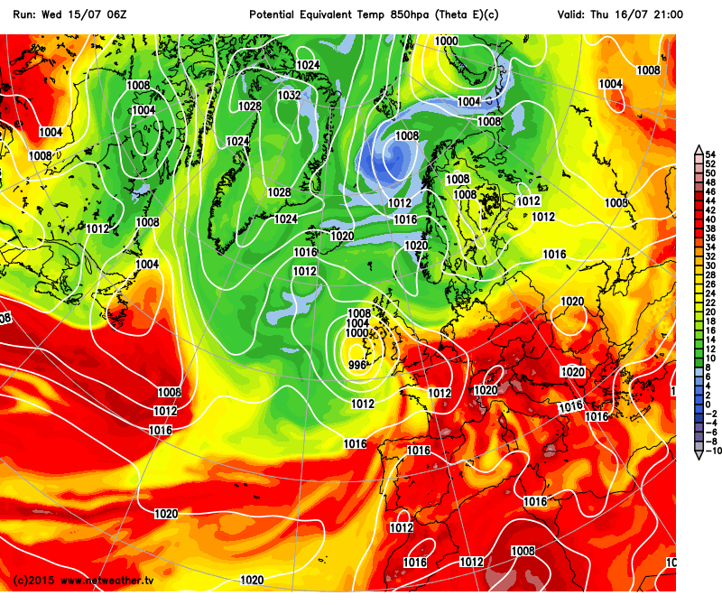
A warm and humid flow returns to start next week, this time from the southwest, but low pressure close to the northwest and Atlantic fronts moving in probably bringing some rain across all parts at some point on Monday. Rain perhaps heavy and thundery across central and northern parts. Rain clearing Monday PM to fresher and clearer conditions later in the day and through Tuesday, but also some showers for western areas. For the moment, it's looking mostly dry mid to late next week, though there will always be a risk of scattered showers developing in places. The flow generally from the west from mid-week, so temperatures nothing to write home about for high summer. Wednesday, Thursday and Friday reaching the low 20s across central, southern and eastern England, mid-to-high teens elsewhere.
Warm airmass returns to start next week from the SW
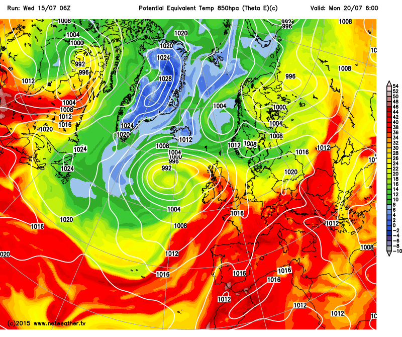
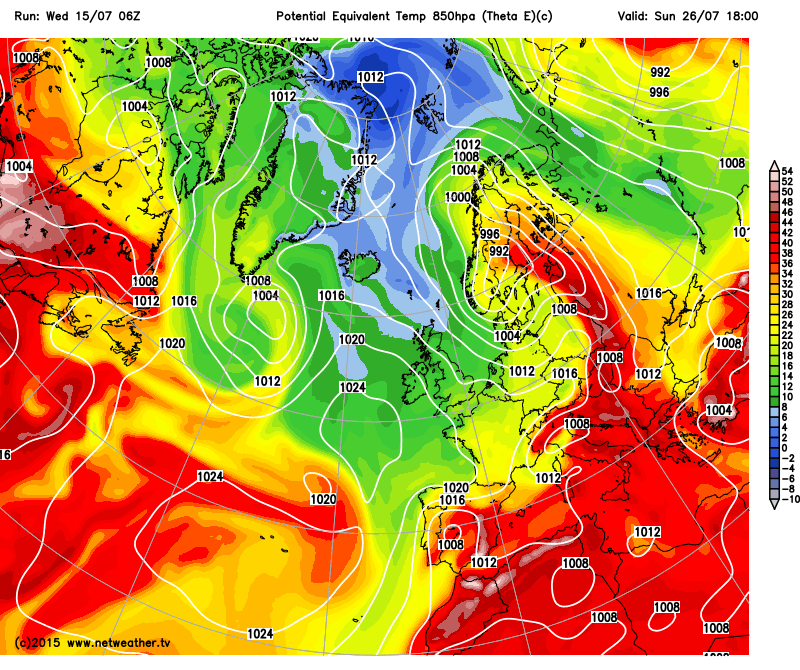
Some uncertainty as we head into the last week of July, as would be expected at that range. Through much of next week, a SW to NE long-wave trough axis will lie just north and west of the British Isles, slowly edging southeast, so by the weekend of 25/26th the long wave axis starts to cross the UK. This will mean the westerly or southwesterly flow could veer northwesterly or even northerly that weekend and as we start the last week of July. So turning cooler with temperatures below falling below par of what we'd expect in late July. There is chance that the models maybe too progressive in moving this LW trough east and we remain in a slightly warmer southwesterly flow, but no signs at the moment of a heatwave other than brief heat returning in the far south tomorrow.
Cooler airmass from the north perhaps threatening the start of the last week of July?