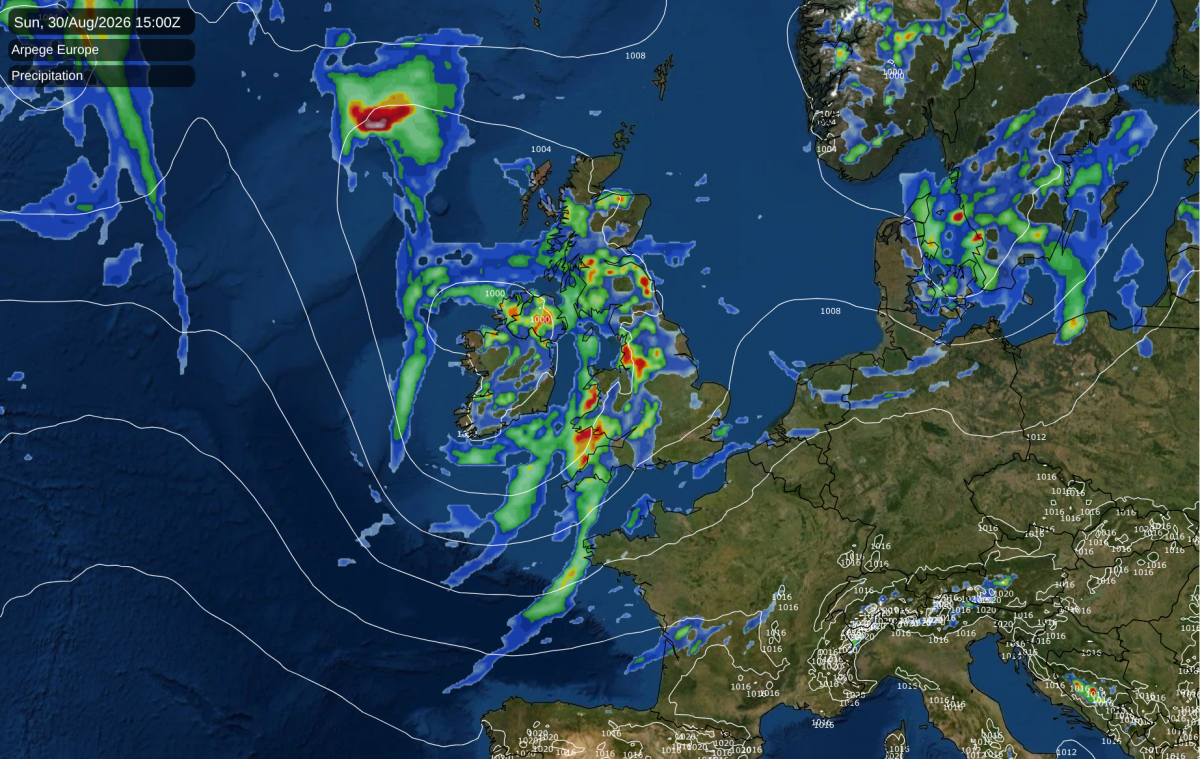
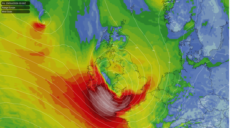
Summer 2026 is still on track to be the hottest on record in the Central England Temperature series and for at least some of the UK, but this is due to episodes of exceptionally hot weather earlier in the summer. The summer is set to not end on a particularly hot note, with low pressure systems frequently coming in off the North Atlantic Ocean, and temperatures close to the long-term seasonal average.
There will be plenty of heat bottled up in north Africa and southern Europe, which is forecast to be up and down during the coming 10 days. Parts of eastern Italy are forecast to be particularly hot today, with top temperatures in excess of 40C. This will head into parts of eastern Europe early next week, where temperatures may hit the mid-30s Celsius in some areas.
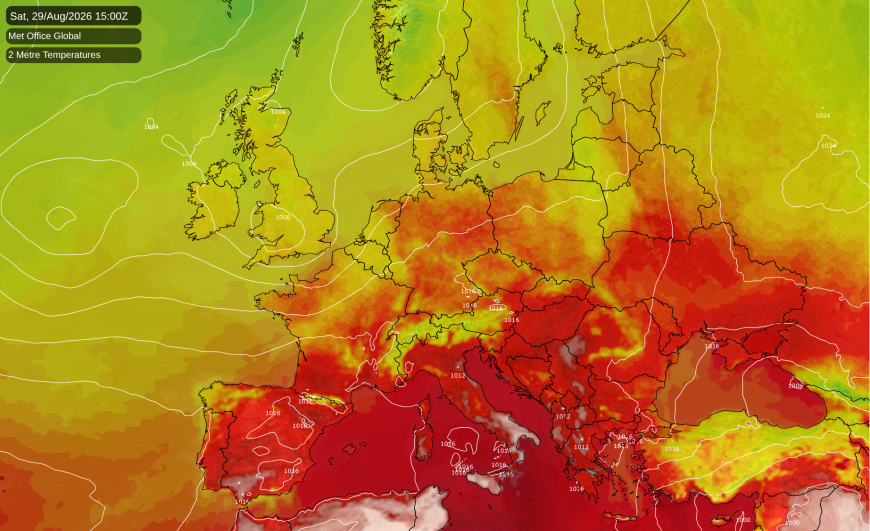
Temperatures are set to remain above the long-term seasonal average in most of the southern half of Europe during the coming 10 days, but with some episodes of unusually hot weather interspersed with less exceptional but still above-average temperatures. There is potential for Britain to end up tapping into some of this heat if we get a ridge of high pressure moving to the east of Britain and introducing a southerly airflow. However, at present there is no consensus among the medium range forecast models of any coming our way during the next 10 days, which look set to remain changeable and dominated by mainly westerly winds. There are tentative signs that high pressure may build from the south into the second week of September, but it is unclear whether this will last for long.
It has also been a hot summer in North America, where according to the National Oceanic and Atmospheric Administration (NOAA), July 2026 was the hottest calendar month on record (records go back to 1895) over the contiguous United States. The previous record hot July in 1936 was exceeded by 0.8 degrees Fahrenheit.
According to Climate Reanalyzer, which uses data from the ERA5 reanalysis, global surface temperatures during August so far have nudged into record warm territory, meaning that August 2026 is looking likely to be the warmest August on record globally. There is still only a slender margin over the previous warmest years, and this may well continue for the month of September, as September 2023 was particularly warm globally. The El Nino event in the Pacific Ocean is set to intensify during the rest of this year, bringing a substantial chance of global temperatures being more clearly record warm as we head through October to December 2026 and into early 2027.
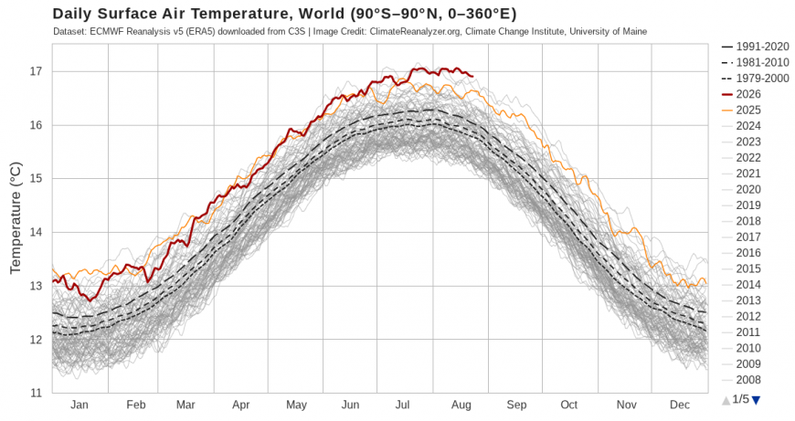
This global surface temperature statistic includes temperatures over both land masses and oceans. Over the land masses, on average, temperatures are yet to reach record highs, but over the oceans they have soared to record high levels. The average temperature of the world's oceans outside of the poles reached a new record high of 21.1C around 10-11 August, and provisionally look to have exceeded that mark during the following ten days.
If monthly temperatures are record warm globally, it doesn't mean that Britain will necessarily be record warm, as individual regions can still be near average or cooler than average during a very warm spell globally. But while El Nino has only indirect impacts on the weather of north-west Europe, there is a tendency for strong El Nino events to be linked with mild and wet weather during November and December.
In both 1997 and 2015, which saw the onset of intense El Nino events, September and October were relatively dry and quiet - both Septembers were dry and sunny for most of the country, as was October 1997 - with near or below normal temperatures. November and December were then mild and wet, with record breaking temperatures in the case of December 2015. December 1997 was on the warm side but not as exceptionally so, due to some colder weather at the start of the month via northerly winds, and an easterly around midmonth which was rather tame in Scotland and northern England, but delivered snowfalls to much of the southern half of England, unusually including lowland parts of Devon and Cornwall, on the 17th.
It is worth noting that 2009/10 was also an El Nino winter. That season, too, started with a mild and very wet November, but the mild wet weather petered out during the first half of December. Then the rest of the winter was generally cold with a number of snow events, particularly during the second half of December and the first half of January. 2009 also saw relatively quiet, settled conditions in September and October.
It is "touch and go" as to whether 2026 ends up as the warmest year on record globally - as things currently stand, it will require the September-December period to be record warm globally by a fair margin - but it is looking considerably more likely for the UK, particularly for England, where temperatures will need to be below the 1991-2020 average during the last four months of the year for the previous record to not be broken.
Loading recent activity...