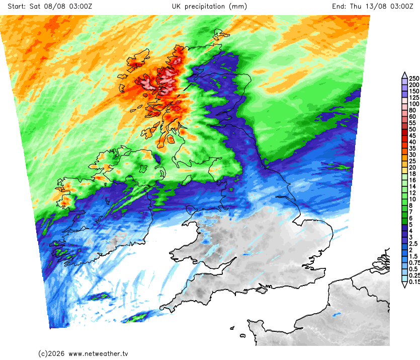
There will be localised exceptions, but once again the majority of model outputs are suggesting that there will be very little rain in the southern half of England during the next 10 days. Substantial rainfall over the next 5-6 days looks set to be mainly confined to western Scotland, but much of Scotland and northern England can expect substantial rainfall in about a week's time.
The outlook is for high pressure to remain close by for some time, although towards mid-August it looks likely to move to the west of Britain, giving northerly winds and, consequently, cooler temperatures, though still no lower than the long-term average for most regions. There is potential for high pressure to stay close by for much of the rest of August as well, although uncertainty over this increases after midmonth. There are signals suggesting that in the second half of August, high pressure may often be centred predominantly to the west of Britain, which, if it comes off, may result in a generally cooler second half of August, but further hot weather is possible if the high pressure ridges eastwards at times.
At present, conditions look set to be cloudy in the west of Scotland on 12 August, particularly towards north-west Scotland, and possibly also over much of Northern Ireland. Skies look likely to be predominantly clear over the southern half of England. Other regions may have some high cloud, but it is currently looking probable that most of the country will have at least some sunshine coming through.
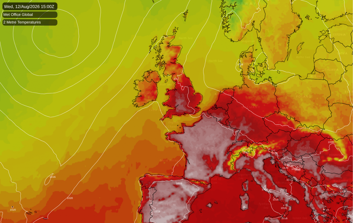
Another heatwave looks set to build around the 12th-14th August as well, as high pressure moves to the east and brings a sluggish southerly air flow. Temperatures look likely to rise into the high 20s Celsius in parts of Scotland. In England and Wales, especially southern and eastern England, it is looking set to be hotter than that, and there is potential for some spots to hit 35C. While subject to change and not guaranteed, this creates a real possibility of us ending up with a remarkable statistic where every month from May to August inclusive sees 35C somewhere in the UK at some point. Until the mid-2010s, the majority of years never reached 35C at all. This hot spell may also be accompanied by yet another 40C heatwave over France, especially the southern half of France.
We are only in early August, but in the Central England Temperature series from 1659, the temperature anomaly for the rest of the year only needs to be 0.5C above the 1961-1990 average, and around 0.3C below the most recent 30-year mean (1991-2020) for us to beat the annual record of 11.23C set last year. In the 20th century, the long-term normal tended to be around 9.5C, but most recent years have been producing an annual mean around 11C. If the weather continues as anomalously warm as it has so far this year, we could end up with an outturn near 12C, but sustaining that level of anomalous warmth through September-December looks unlikely.
Forecasts for the El Nino Southern Oscillation of 2026/27 are currently remarkable, with sea temperature anomalies of 3 to 4C widely predicted over the Nino 3.4 (central equatorial) region of the Pacific. If these forecasts verify, it will end up as easily the strongest El Nino on record.
Major El Nino events are usually associated with a temporary spike in global temperatures, as much as 0.2-0.3C above baseline levels. In the current warming climate, major El Nino events tend to set new high global temperature records, which then typically stand until the next strong El Nino comes along. The 2023/24 El Nino was unusual in that global temperatures soared to record highs just as the El Nino event was getting underway. Normally, periods of high global temperatures lag the El Nino slightly and we see global temperatures peak towards the end of an El Nino event.
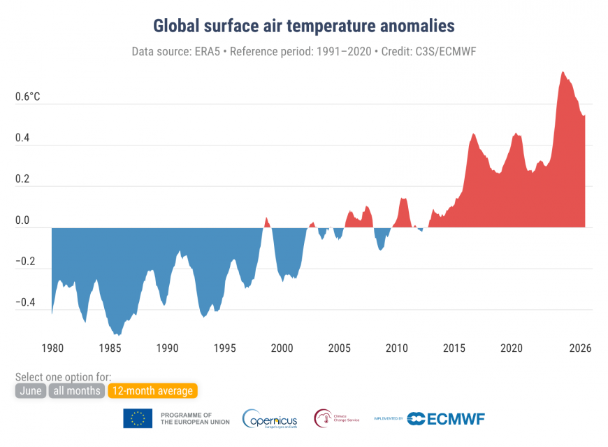
This year looks to be following the more typical pattern. According to the ERA5 reanalysis product, averaged globally (including temperatures over land masses as well as oceans), 2026 has mostly been within the top 5 warmest years on record up until June, but not generally the warmest. Currently it is rising to be roughly joint warmest. However, global sea surface temperatures are more remarkable. Until May, they were running at second or third warmest on record, but since June, they have been pushing into new record territory, and this looks set to continue for upcoming months. We can expect some new global temperature records to be set during the coming autumn and winter, especially given the exceptional strength of the El Nino event that we are moving into.
These results show that we get considerable regional variability on top of the global mean, for while 2026 has not been a record breaking warm year globally so far, it has comfortably been running at record warm levels over much of Britain, particularly the south.
Loading recent activity...