Parts of England and Wales are heading into the fifth heatwave of the year from Sunday, with temperatures forecast to peak at 35°C next week following a brief drop in temperatures during the second half of this week to more average to slightly below values
After a cooler end to the week, heat will build again from Sunday across England and Wales, with peak of heat likely Wednesday and Thursday. Scotland and N. Ireland cooler on Monday but even here warming up next week.
The UK Health Security Agency (UKHSA) has already put further yellow heat health alerts in place for the majority of England starting Saturday, 8 August at 9am through Tuesday, 11 August at 9pm.
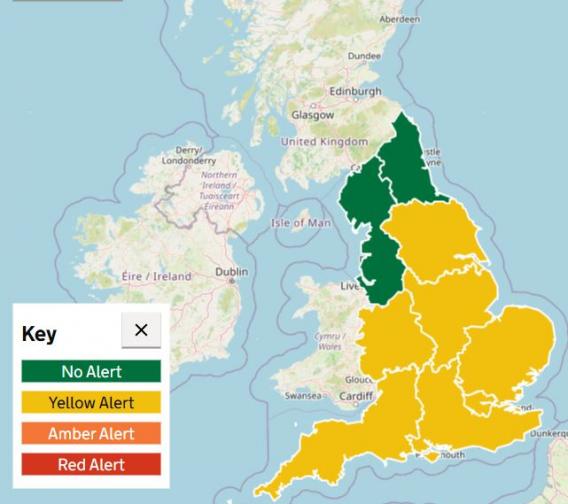
After a brief drop in temperature and humidity mid-week, high pressure is building back from the south this weekend - with a change in wind direction to a south or southwesterly flow - which will draw in warmer air. Weather models show a prolonged, six-day stretch of temperatures reaching the high twenties widely inland across England and Wales, locally low to mid-thirties Celsius across southern, central and eastern England beginning this Sunday. This will mean Met Office heatwave criteria will be met across many parts of England and Wales.
Saturday will see temperatures increase across England and Wales to reach the high 20s Celsius across eastern and southern England - which meets the Met Office heatwave criteria.
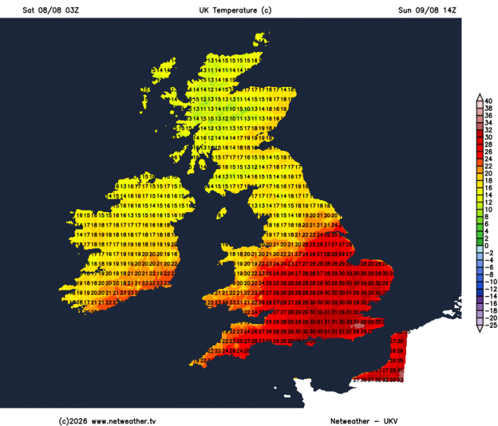
Sunday will see temperatures climb further, reaching 30-32°C in SE England and mid-to-high 20s elsewhere across southern, central and eastern England.
Temperatures are expected to be a few degrees down on Monday, but still reaching heatwave criteria of 27-28C across southern, central and eastern England, perhaps an isolated 30C across the far south of England.
Tuesday the heat may be greatest further west from Cheshire down to Somerset and into east Wales - where temperatures are forecast to reach 30C, thanks to an easterly or southesterly breeze developing keeping eastern areas of England less hot but still reaching high 20s inland, cooler along eastern coastal areas
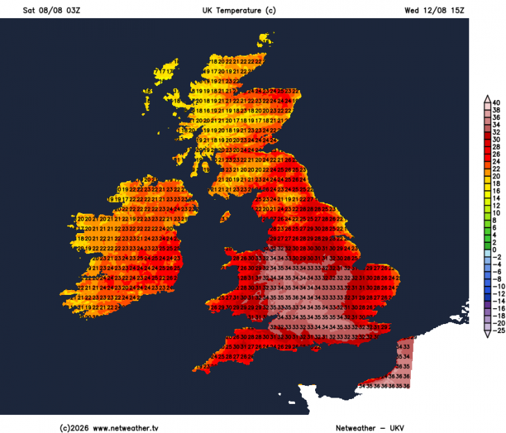
Wednesday and Thursday hotter still, and either day likely to see the peak of the heat, with temperatures widely in the low thirties inland across England and Wales, with 34-35°C forecast across The Midlands and southern England on Wednesday and similar temperatures towards eastern Englandon Thursday, perhaps 36C locally. High 20s to low 30s widely inland elsewhere across England and Wales.
Friday likely to be hot again in southern England, perhaps reaching 30C, though not as hot generally across England and Wales.
Nights during the heatwave will become more uncomfortable, with "tropical night" conditions possible, where temperatures stay above 20°C overnight.
Little or no rain is expected across large parts of England and Wales - where the highest temperatures are forecast. The dry ground likely helping increase temperatures - as dry soil doesn’t soak up heat from the sun like wetter ground does, so temperatures at the surface are higher.
An official drought remains active for more than half of England. A village in Surrey (Wisley) has recorded 50 consecutive days without rain.
Major supermarkets have pulled disposable barbecues from shelves as firefighters continue to battle widespread wildfires across the countryside.
No rain forecast for much of England and Wales through to next Friday, Scotland and N. Ireland will see some from Atlantic fronts.
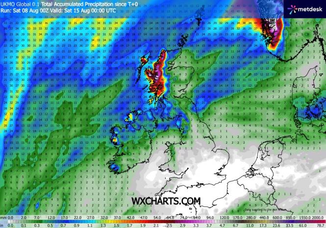
The only rain in the UK will fall mostly across Scotland and N. Ireland over the weekend and next week and it won’t be as much earlier this week away from the far northwest, thanks to high pressure building in. A cold front moving down will bring a band of rain south across Scotland this weekend, weakening as it moves south across the north of England by Monday. High pressure builds in early next week before drifting east to be over northern Germany and Poland later in the week. This will allow Atlantic fronts to return to Scotland and N. Ireland from Wednesday - bringing cooler and cloudier conditions with some patchy rain, though eastern Scotland may stay dry.
Loading recent activity...