It’s been an exceptionally hot and dry summer so far across the southern half of the UK, though for the north it’s been more mixed. June saw record-breaking temperatures and the Met Office has officially verified and confirmed the new record-breaking daily maximum temperature for June of 38.0°C recorded in Lingwood on 26 June 2026 (surpassing the previous provisional reading of 37.7°C) during the intense heatwave later that month.
Temperatures will dip across the south over the next few days, but look to rise again from Sunday and we may see another heatwave develop across southern England and perhaps south Wales early next week, as temperatures climb into the high 20s and perhaps 30C in a few spots. Further north, there is a risk of rain, perhaps heavy and persistent, moving in from the southwest early next week, while there is a chance of showers in the south too, but as they are hit and miss in nature, some may stay dry. Any rainfall amounts in the south unlikely to make much of a dent. Nearly half of England and north Wales is officially in drought.
Heat easing for a few days in the south, but looks to build again from Sunday
It was another hot day yesterday across central, southern and eastern England during a three-day heatwave, the fourth of this year, with a top temperature of 35.2C at Writtle in Essex. The heat yesterday was the northern edge of plume of very hot air surging northeast from North Africa across western Europe, with temperatures reaching 42C in the Dordogne region of western France yesterday, with large areas of mainland western Europe reaching the mid-to-high 30s degrees Celsius.
However, a cold front that brought cloud and rain yesterday across the north will clear south across England and Wales through today, eventually introducing fresher conditions and lower temperatures for all, though temperatures still reaching the mid-to-high twenties in SE England this afternoon.
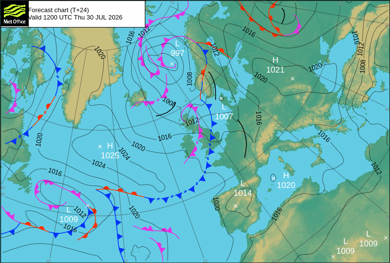
The cold front, currently bringing showers across parts of northern England and Wales, will be little more than a band of cloud with the small chance of a shower by the time it reaches southern England, so no relief from the ongoing prolonged drought here. Scotland, N. Ireland and the far north of England at times will continue to see further showers or spells of rain off the Atlantic over the next few days, though will turn drier and settled by Sunday to join much of England and Wales.
Temperatures will return close to average on Friday and Saturday across the south following the clearance of the cold front today, reaching the mid-20s both days across southern England, the Midlands and East Anglia. Low twenties further north and west over England and Wales, mid-to-high teens for Scotland and N. Ireland.
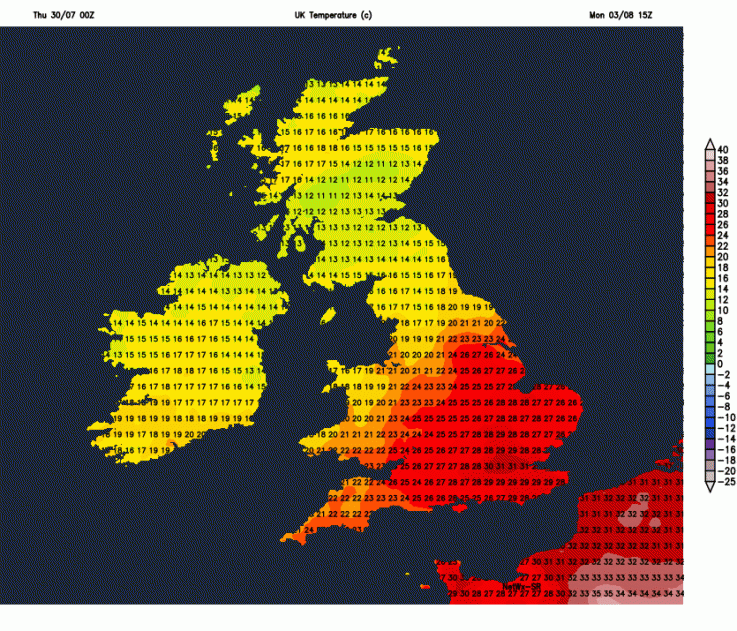
However, temperatures are forecast to be on the rise again from Sunday and could reach the high 20s across southern England on Sunday, then Monday, Tuesday and Wednesday could be hot across the south, with 30C showing on some models across southern England.
Potentially hot on Monday and perhaps Tuesday and Wednesday too - a fifth heatwave?
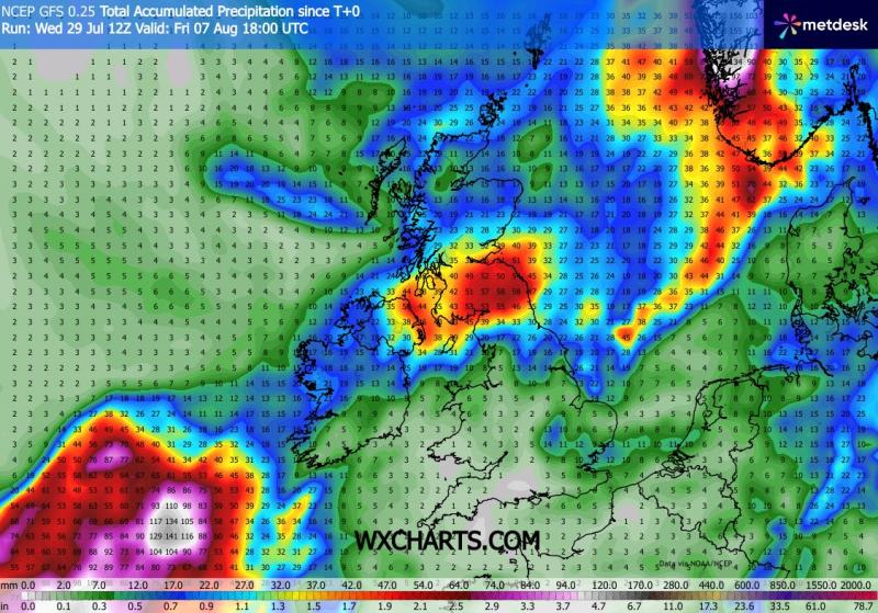
Meanwhile, pressure does look to fall from the southwest from Sunday, as an area of low pressure over the Atlantic approaches SW Ireland by Monday before drifting east across southern UK on Tuesday. This low will likely bring outbreaks of rain or showers for some during the first half of next week, with more persistent rainfall likely to spread northeast across Ireland then across Scotland and northern England on Monday and Tuesday, perhaps heavy in places.
Low pressure approaches from the southwest late this weekend before moving across the south early next week, bringing increasing opportunties for rain, though showery rather than prolonged in the south
But, there’s uncertainty how much, or indeed, if any rain there will be for southern areas which have not seen any rain for over a month. Some weather models suggest scattered showers are possible for southern areas Monday to Wednesday, but with many places staying dry and sunny and very warm or hot. There is a chance of more organised rainfall for parts of the south too, but lower confidence on this, showers seem more probable and, we know, these can be hit-and-miss.
Could be quite wet in places across the north next week, but in the south rainfall will be more showery, so some places may stay dry
It looks to remain very warm or locally hot across southern England and south Wales later next week, though with a risk of showers. Further north across England and Wales - not as hot but still warm and with high pressure building in across the north it will be mostly dry and settled.
Loading recent activity...