This July has so far been exceptionally dry for much of the country, continuing a long dry spell of weather that has been ongoing since mid-June. Some places have had over 40 consecutive days without any measurable rain, rivalling long dry spells in 2018 and 2022. I have been in Lincoln and Exeter this month and in both locations the grass has gone bare and yellow. While Exeter gets relatively wet winters, its summers are often as dry as those of eastern England, especially with being sheltered by Dartmoor to the west.
There will be some rain for most of us over the weekend, spreading south-eastwards via a frontal system and ending the long anticyclonic spell. This is forecast to provide a few millimetres over much of Scotland and parts of northern England, but over a large part of England and south and east Wales, it is not forecast to amount to much. Then during the rest of July, we look set to move into a pattern with a north-south split, with high pressure ridging close to the south of England, and mainly westerly winds.
Forecast rainfall totals during the remainder of the weekend
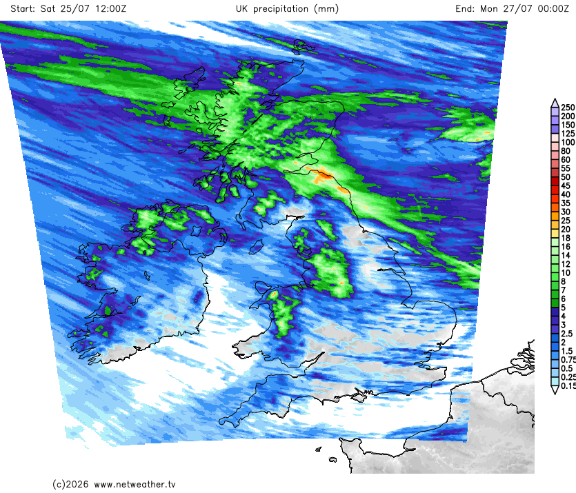
This means that, again, much of Scotland, northern England and Northern Ireland can expect some meaningful rainfall, but it may stay largely dry in south Wales and the southern half of England. Some medium range forecast runs are predicting less than 2mm of rain for parts of southern England for the next 10 days, which, if it comes off, will maintain the drought.
There is also a general signal for high pressure to be more dominant than low pressure during the first third of August, which has potential to prolong the dry spell further. The 42-day outlooks from the ECMWF have consistently been suggesting low pressure becoming more prominent as we head towards mid-August, perhaps ending the dry spell in southern Britain, but this is around 20 days out, so confidence in this is relatively low.
At the time of writing, the Central England Temperature for July is running at 19.6C, which is 0.2C below the record, set in 2006. The northerly winds of the past week brought it below record breaking territory, as it had been running at around 20.5C in the middle part of July. With us moving into a more unsettled spell of weather, there is potential for that figure to further reduce slightly.
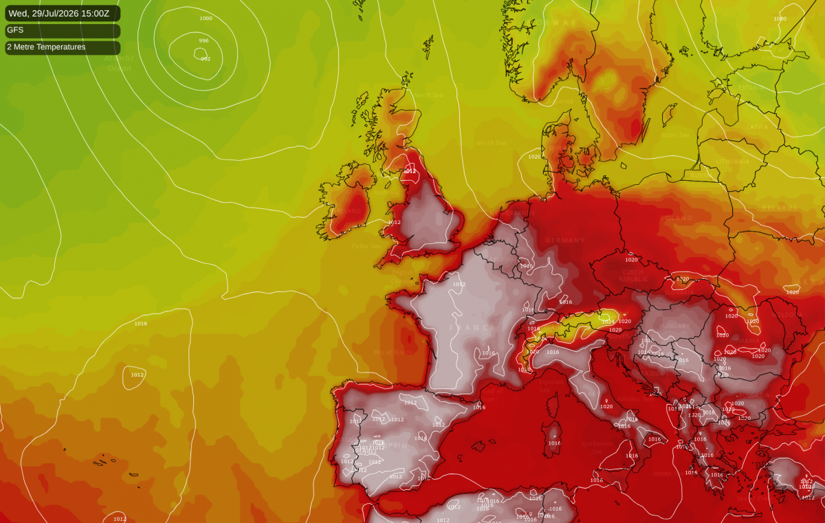
However, many of the forecast models are showing a ridge of high pressure developing to the south-east of Britain on 28 July, with another marked heat dome developing over France and Spain, and then sending in a southerly on 29/30 July. If this comes off, it will only be a one or two day hot spell, but there is potential for it to end up exceptionally hot in parts of England in particular.
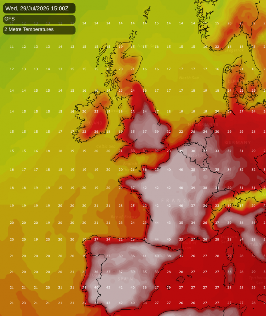
Most forecast model runs take the hot weather mainly into south-east England, where temperatures could hit the low to mid-30s Celsius, with cooler weather hanging on in most other parts of England. However, for two consecutive runs, the American GFS (Global Forecast System) model has been predicting highs of 35-38C over a large part of England. If the hotter scenarios come off, then they may push the Central England Temperature above the record of 19.8C set in July 2006.
For parts of southern England, it is more likely that long-standing records will be broken, as these regions were particularly hot in the second week of July and saw less of a cool down last week than other parts of Britain. South-western Britain has so far been particularly hot this month. It is worth noting that over much of the south-west, July 1983 still stands as the hottest July on record, rather than 2006, as July 2006 was particularly hot in eastern Britain.
Northern and eastern Britain have seen more cloud at times during the recent spell of northerly winds, and it was also rather cloudy in the north during the first week of July, so many areas of northern and eastern Britain currently do not have remarkable sunshine totals. However, large areas of south-western Britain have had an exceptionally sunny July so far. According to Dan Harris's Starlings Roost Weather, up to 24 July, sunshine totals have so far included 303 hours at Hurn, near Southampton, and 282 hours at Exeter Airport. With a north-south split expected for much of the rest of July, sunshine totals for July 2026 in south Wales and south-west England have potential to widely push above 300 hours.
Loading recent activity...