Large parts of England and south Wales will continue to endure low-end heatwave conditions from Tuesday through to Friday - as dry and sunny conditions continue through much of this week, with temperatures reaching the high 20s and locally low 30s in the south. Though by the weekend, we will see an easing of the heat, as a north to northwesterly flow develops
Information
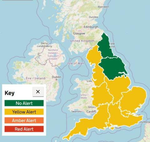
Yellow heat health alerts issued for the East Midlands, East of England, London, North West, South East, South West and West Midlands
Regions affected include the East Midlands, East of England, London, North West, South East, South West and West Midlands from 9am on Tuesday 14 July until Friday 17 July at 9pm. For more information, please see the Weather health alerts page.
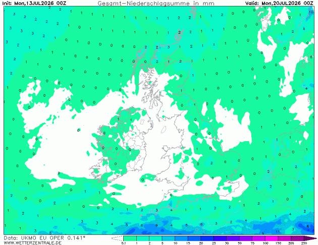
However, there looks to be little or no rainfall for the next 7 days at least for most of the UK too, as high pressure remains firmly in control, with a dry northeasterly wind over the next few days eventually backing northerly then northwesterly. But fortunately these wind directions will bring low humidities, so it will feel more comfortable, particularly at night.
Little or no rain for most for the next 7 days
The heat has been more focused across Wales and western parts of England over the weekend, thanks to a strengthening easterly or northeasterly wind developing, bringing some relief towards eastern areas with cooling flow off the North Sea. Saturday’s top temperature was 33C at Yeovilton in Somerset and yesterday saw a high of 32.6C at Hurn in Dorset.
Although it’s clear blue skies across large parts of the UK this afternoon, not so hot today, as a strong northeasterly wind blows, particularly across the Midlands - which saw early cloudy skies that spread in overnight. The gusty winds across England and Wales will unfortunately fan the flames of wildfires which have broken out in places. A few showers may move into southern counties tonight, but that's the only chance of rain.
Tuesday will see a continuation of mostly dry and fine weather across England and Wales. Scotland and Ireland will see slightly hazier sunshine. Temperatures reaching 30C across southern England. A small risk of early isolated showers in the far south.
Wednesday sees high pressure firmly established over the entire UK. Warmer air reaches into eastern Scotland and Northern Ireland, making it a fine and sunny day nationwide, temperatures reaching 25C across western Scotland and N. Ireland, cooler towards eastern Scotland. Down south we could see 29-30C across southern England and south Wales.
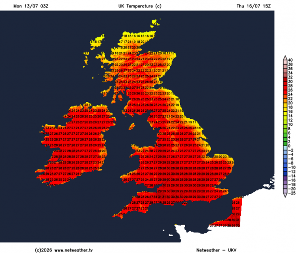
Thursday will likely see another dry day with plenty of sunshine, a hot day for southern and central areas of England with temperatures reaching 27-30C, very warm elsewhere too, up to 25-26C in western Scotland and N. Ireland.
Widespread very warm or hot conditions on Thursday - even for Scotland and N. Ireland
Friday onwards - the heat eases southwards as a northerly flow develops. Still dry and eventually sunny for most, though low cloud rolling in Thursday night across northern and eastern areas may be stubborn to burn back to coasts at first. Temperatures reaching 25-28C across central and southern England along with south Wales, low 20s for north Wales and northern England northwards.
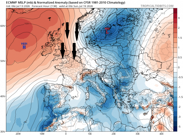
A strong area of high pressure will be centred to the west of Ireland over the weekend, low pressure way to the east moving across Poland and the Baltic States - so the dry and settled weather continues for most. Still very warm or locally hot across southern and central England and perhaps south Wales, with temperature reaching the high twenties, elsewhere low to mid-20s. The northerly breeze will make it feel comfortable though, especially at night, by bringing low humidities.
High pressure centred west of Ireland at the weekend, with a northerly flow, so low humidity making it comfortable, even though temperatures may reach high 20s in the south.
Not much sign of things changing a great deal into next week either, as model ensemble guidance suggests high pressure to the west drifting east over the UK - continuing the dry and settled conditions for most, though the far north may become more unsettled with fronts spreading cloud and occasional rain east off the Atlantic.
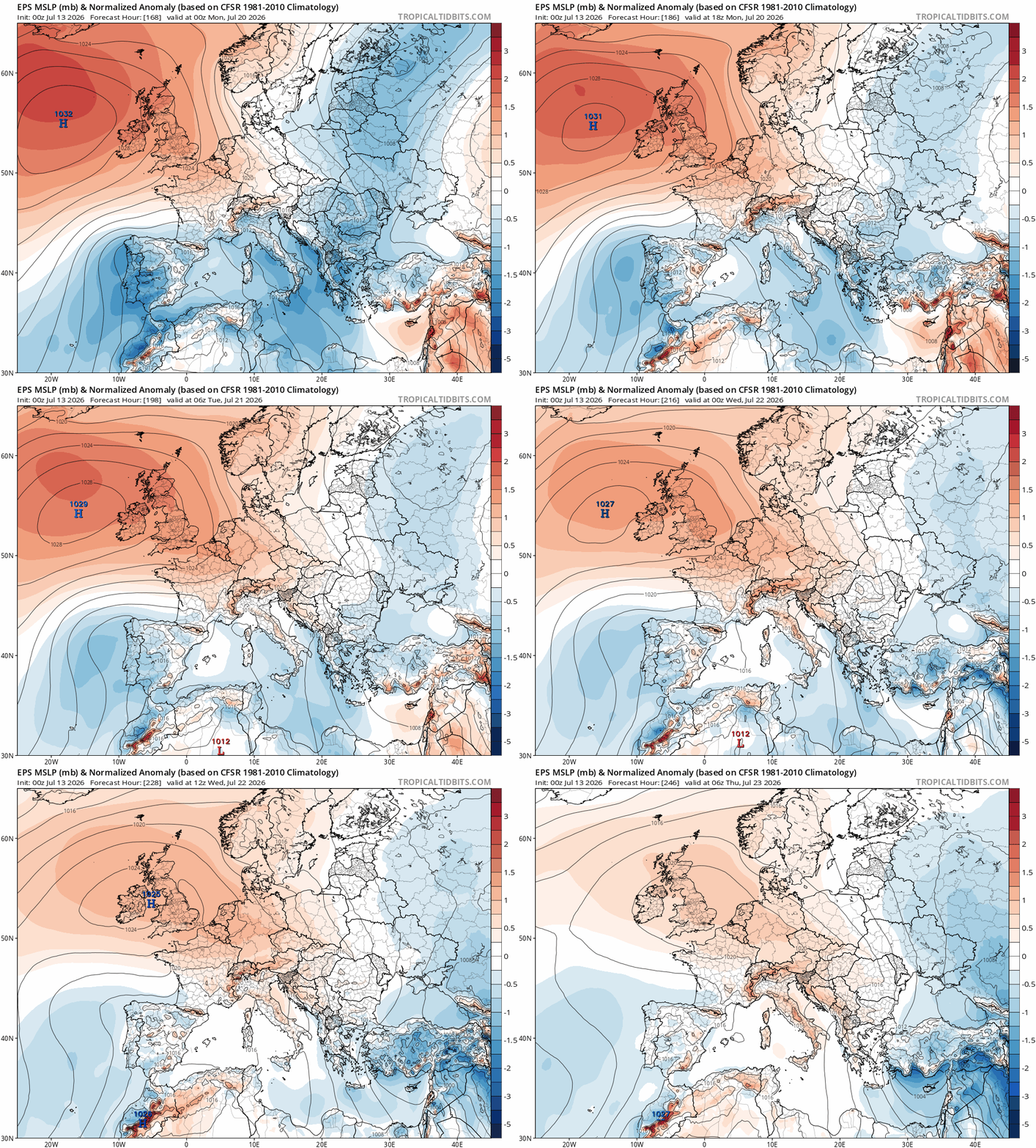
So prepare for another 7-10 days of little or no rainfall. This will put increasing strain on water resources and demand, impacting agriculture and also tinder dry vegetation in the countryside and the low humidities will mean the land will be very susceptible to wildfires over the coming days.
Loading recent activity...