There is a high chance that the UK could record its highest June temperature on record this coming week, as an extreme heatwave develops over large parts of England and Wales. This follows shortly after the UK recorded its highest May temperature on record only a few weeks ago, though the heatwave intensifying through the coming week will be accompanied by higher humidity too, making it feel more uncomfortable. While ‘tropical nights’, where the temperature doesn’t fall below 20C at night, are likely in some areas too, which will mean no relief at night either.
Heat building through the coming week, perhaps setting a new June maximum temperature record from Tuesday
The Met Office has issued an amber extreme heat warning for Monday and Tuesday - which covers most of southern England, east Wales, the Midlands, East Anglia and Lincolnshire. This warming could be extended over Wednesday and Thursday too, as temperatures will be equally if not hotter than Tuesday.
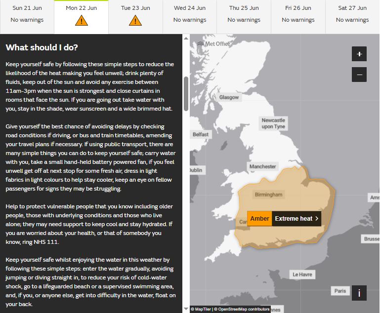
Amber heat health alerts are also in force for the Midlands, east of England, London and all of southern England. These are issued when significant impacts are likely across health and social care services due to the high temperatures
There is a strong chance, looking at temperature predictions from weather models, of beating June's highest-ever temperature of 35.6C (96F), set in 1957 and 1976. Many models are showing temperatures reaching 38C across parts of southern England on Tuesday and Wednesday, some go as far as predicting 40C, though this seems unlikely.
UKV showing 40C on Thursday
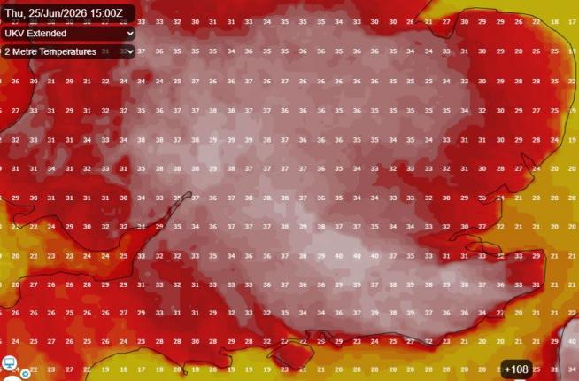
Even in northern England, Manchester could reach 32C, Newcastle 29C on Tuesday and Wednesday. And although not the extreme heat as further south, very warm and humid conditions will reach Scotland and N. Ireland too, with 26C in Glasgow and 27C in Belfast on Tuesday.
After a ‘cooler’ day on Saturday, thanks to cloudier skies through much of the day across England and Wales from weakening fronts, the heat returns to southern areas on Sunday, thanks to clearer skies. Today marks the summer solstice too, with 16-19 hours of daylight to make the most of. Most will remain dry with plenty of sunshine, though skies may become hazy a times from high cloud. Chance of an isolated shower developing over NE England and NW Scotland. We could reach 30C in London today, 24-27C elsewhere over England and Wales, away from coasts which will be cooler. 18-21C in Scotland and N. Ireland.
Another hot, sunny and mostly dry day on Monday across southern areas, temperatures reaching 31C in southern England. More in the way of cloud across northern areas, with chance of a few showers. There is also a risk of isolated heavy showers or thunderstorms developing over Wales and northern England during the evening, these could spread further southeast across England overnight.
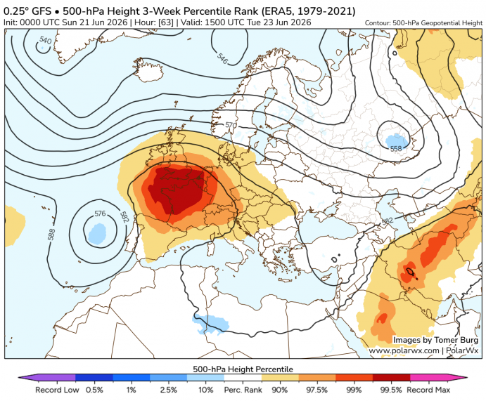
A strong upper-level ridge building over SW Europe today, bringing extreme heat to Iberia and France, with 41-42C expected in SW France, will extend into southern UK on Tuesday - bringing with it hotter air from France. With clear skies and strong sunshine, temperatures are forecast to reach at least 35C across parts of southern England, perhaps locally higher in a few spots. Mostly dry, sunny and very warm elsewhere, though cloudier across northern Scotland. Just the outside chance of an isolated thunderstorm developing across northern England.
Similar story on Wednesday, very hot and dry over much of England and Wales, very warm over Scotland and N. Ireland too. Temperatures reaching 32-36C across southern and eastern England, The Midlands and south Wales, not as hot the further north you go, temperatures in the 20s.
Changes across the west later in the week may bring some showers or thunderstorms
Thursday may see some changes in the west, as low pressure approaches from the southwest, with heavy showers and thunderstorms breaking out, a few isolated storms may arrive across southern England late in the day too, otherwise another very hot and sunny day for central, southern and eastern areas - temperatures again reaching the mid-30s in the south.
Friday looks like another very hot for England and Wales, as high pressure builds back in, temperatures reaching the low 30s, Scotland and N. Ireland will be cooler and cloudier with outbreaks of rain, perhaps thundery, with low pressure moving northeast here.
Temperatures finally falling back to more normal values by the end of next weekend in the south, as low pressure to the northwest pulls in fresher air off the Atlantic but also weather fronts bringing showers or longer spells of rain, but also with some warm sunshine in between.
Loading recent activity...