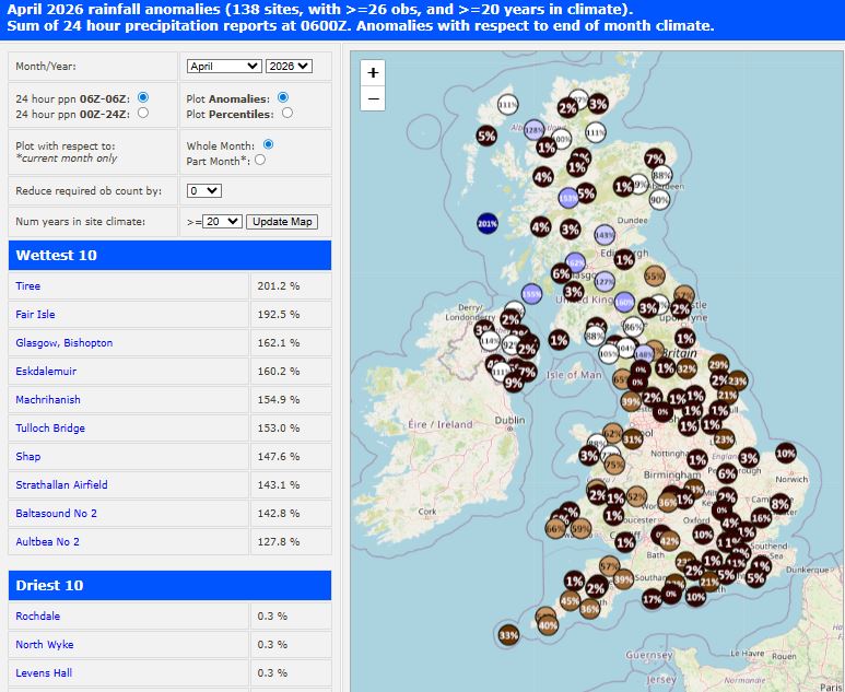
I probably don’t need to tell you that it’s been rather dry this month, especially towards the eastern side of the UK - where parts of SE England, East Anglia and even eastern Scotland have only seen 1-2% of the average April rainfall.
There are some chances of rain over the coming days, including today, later in the week and through the Bank Holiday Weekend. However, rain will be in the form of showers, which can be hit and miss, so not everywhere will see similar amounts of rain, with some getting wet briefly and others staying dry. It won’t be enough to change what will be a very dry April and high pressure will dominate for much of this week, bringing mostly dry and settled weather, with an easterly wind picking up from Tuesday, bringing low humidity air with it, which will only accelerate drying of the ground after any rainfall today.
Some useful rain for some over the coming 7 days? Not alot, even for those that do see rain, as not everywhere will get a soaking
Although high pressure is centred over western Ireland this afternoon and pressure is generally high at the surface, a fairly weak shortwave upper trough is dropping south across the UK today, which is steepening lapse rates and creating lift of warm air at the surface - supporting heavy showers to develop and spread south across Scotland and Northern England this afternoon, with lightning detected over the Peak District.
500 hPa cyclonic vorticity charts show shortwave upper trough dropping south, trigger showers across N England early evening
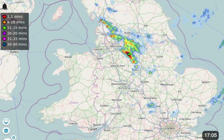
The area of heavy and thundery showers over northern England will continue to spread southeast across the Midlands on the leading edge of cold pool / upper trough moving south, eventually reaching SE England later this evening. Not everywhere in these areas will catch one, but they could be locally heavy, with the odd rumble of thunder.
High pressure builds northeast across northern UK and ends up centred over the North Sea from Tuesday, bringing a return to dry and settled conditions for many until later in the week, but with a cool easterly wind returning in the south.
By Thursday, the high over the North Sea slips southeast over central Europe, the upper low that drops south today will end up over the Bay of Biscay by mid-week before drifting northwest, this will pull low pressure centred over northern Spain mid-week northwest to be to the southwest of Ireland by the end of the week. Showers in the northern circulation of this low, as it drifts towards SW Ireland, may clip Cornwall as early as Wednesday and continuing on Thursday and perhaps also affecting west Wales and N. Ireland and eventually western Scotland too on Thursday.
There is some uncertainty, though, later in the week, on whether the low to the southwest of Ireland ejects north-northeast to be to over or to the north of Scotland on Friday like 00z GFS and UKMO or the low hangs around close to southern Ireland before filling and drifting east like 00z ECMWF.
This has a knock-on effect on shower distribution on Friday. The more recent 06z and 12z model runs so far do suggest some showery activity spreading northeast across England and Wales, though rainfall distribution uncertain.
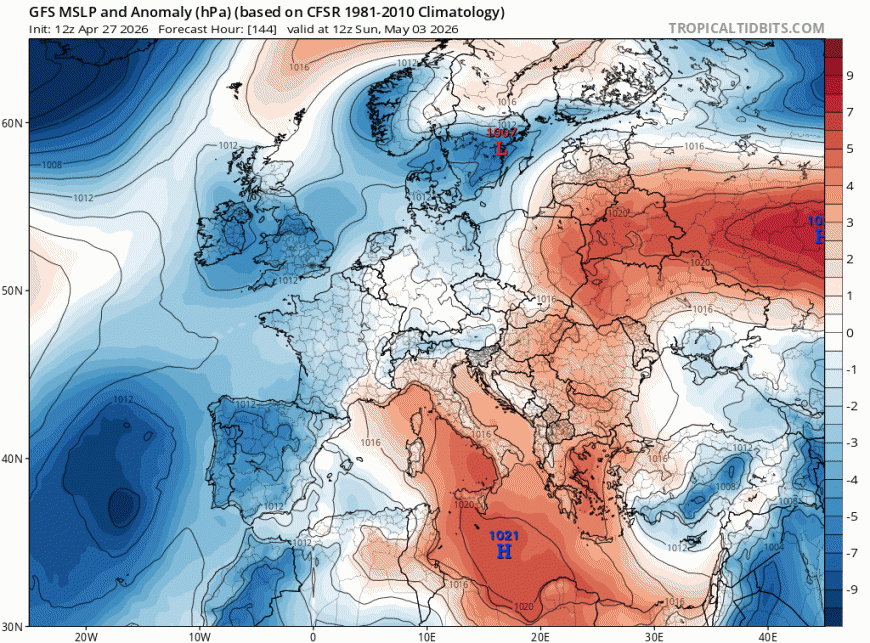
The Bank Holiday Weekend is looking even more uncertain, though it is unlikely to be a washout in any particular area, there will be a risk of showers over the long-weekend, but pinpointing where and when is still proving a little tricky for now. Saturday and Sunday, for now, look to see the greatest risk of showers looking across all models that go that far out, with shallow low pressure looking to drift east or northeast across the UK. Though, again, can’t really give any confidence on detail of where showers will be most likely both days. There will likely be some sunny spells and feeling warm in light winds, with temperatures reaching the low 20s.
Low pressure looks to drift east across the UK over the BH Weekend - bringing the risk of further showers, especially Saturday and Sunday
High pressure looks to build in from the west on Bank Holiday Monday, as low pressure moves away east, so any showers becoming confined to the east or southeast and NW Scotland. With the flow from the west or northwest by then, it may be cooler than Saturday and Sunday.
Loading recent activity...