Atlantic weather fronts will hurtle towards the UK over the next few days. That means wet and windy weather but there will be gaps in between with some welcome sunshine. It is already much milder with temperatures widely into double figures.
London has seen 13C today and should reach 15C on Friday but it may not feel that mild in the blustery wind. Glasgow will be around 12C on both days but could feel more like 8C in the rain and fresh, gusty winds on Friday.
This is a dramatic change from the cold, grey sedate conditions that meant some parts of the UK did not see any sunshine for over a week in the middle of the month. We now have a more lively mix with bands of heavy showers, even hail and lightning today sweeping in from the west.
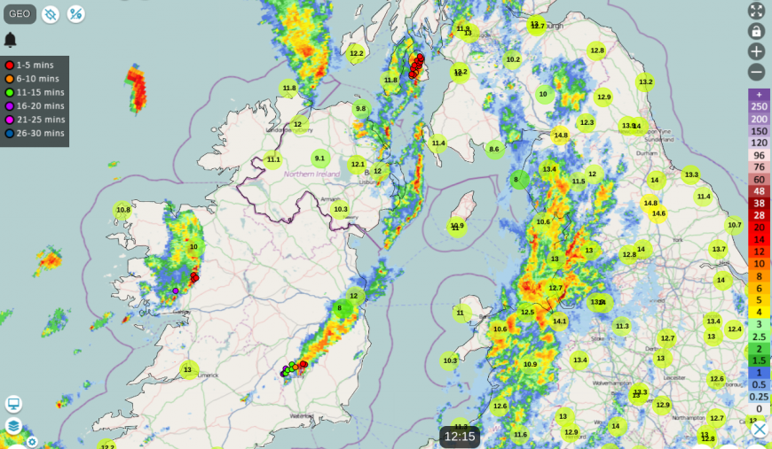
There is a pool of cold air aloft with this milder air at the surface and the instability is leading to clusters and bands of heavy showers. Weather apps may show a showery picture but can’t give the detail of when a downpour will arrive and when it will clear away. It’s a day for watching the radar. Click on the animate/play button on the Netweather Radar and watch the movement towards your location (add your postcode and a marker will appear). If you click Lightning On, the sferics or lightning strikes appear too. Thundery showers continue for SW Ireland as gales develop around the coasts of Ireland today. There have also been thundery downpours for south Wales, Devon and Herefordshire with lightning and squally winds. And a cluster from County Antrim across to the Isle of Arran.
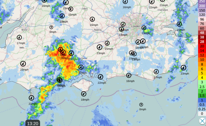
Netweather Radar with wind speeds at 13:20 Thursday
There is a lot of cloud and damp weather across Britain. There are two cold fronts followed by showery troughs. Northern Ireland will see an improving picture today as the showers move away and the skies clear with sunny spells this afternoon. Across Britain, it will be unsettled with occasional bands of heavy showers, perhaps hail and gusty winds leading to poor conditions on the roads as visibility temporarily reduces. The UKV model showers one significant band moving from north Wales over northern England this afternoon and other clusters moving eastwards across Scotland. By this evening, the skies will be much clearer with a lot of dry weather but still the odd heavy shower. For southern Britain there will be plenty of cloud, patchy rain moving over southern England and lingering dampness for Kent and Sussex after dark.
It will stay mild in the south with a hang back of frontal cloud but further north the temperatures will dip away quickly in the evening under the clear skies.
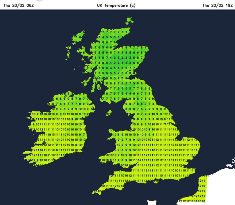
Early evening Thursday UKV temperature chart with cooler conditions over Scotland, very mild for SE Britain
The nights won’t be especially cold as it remains windy in this flow from the south but if you are out after dark it will feel chilly as it will be damp and blustery. The risk of frost looks to return by the middle of next week.
Tonight
There will be a bit of a lull with drier, less blustery weather but the southerly winds will begin to freshen over Ireland and along the west coast of Britain in the small hours. Met Eireann has yellow wind warnings for southern counties and there is a collection of wind and rain warnings from the UK Met Office for Friday.
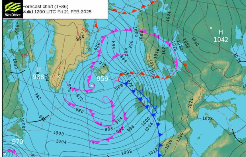
Friday
Friday will be windier than today as a more active system moves through. It will be very mild but with the strongest winds around lunchtime including coastal gales for Northern Ireland and the west coast of Britain. Around the Irish Sea, there could be severe gales for a time as the cold front progresses eastwards and the southerly winds veer to a westerly. The inshore waters outlook for the Isle of Man -
“Wind - South or SE 7 to severe gale 9, veering south or SW 5 or 6, then decreasing 4 or 5 later. Sea state - Rough or very rough, becoming moderate later,”
which could impact ferry journeys. The far southwest of Scotland and eastern counties of Northern Ireland are highlighted for potential wind impacts on Friday.
“Southerly winds will increase on Friday morning, with gusts of 50-60 mph likely for exposed coasts and hills of western Britain. Some parts of the warning area may see gusts of 70 mph for a time. Winds ease from the west during the afternoon.”MO
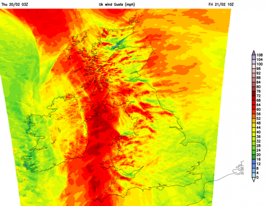
UKV gusts for Friday morning with fresh to strong southerly winds and severe gales through the Irish Sea, gusts over 60mph in exposure
Much of coastal Wales is also under a yellow wind warning on Friday due to “A spell of strong and gusty southerly winds may lead to some disruption to travel and infrastructure”
However, all UK warnings relate to the likelihood of severe weather and the potential impacts. This warning has a medium likelihood and a low impact but other areas will have strong winds on Friday.
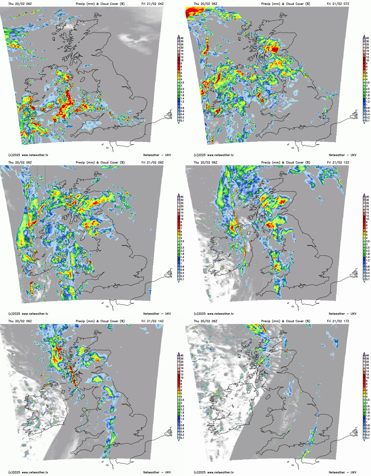
After the lull overnight, the next bout of wet weather will sweep up from the southwest early on Friday. The main focus will push up over Wales into Scotland and over Northern Ireland until the main clearance along the cold front begins after lunchtime. Bands of heavier rain will move over Scotland as skies clear for Northern Ireland with sunshine by the afternoon. Wales and western Scotland could also see a bit of late afternoon sunshine or brightness. Another pulse of rain will nudge up to southeast England during Friday night with clear skies for most of the UK and showers in the far northwest but the winds will have eased.
There are specific areas that are highlighted with the yellow rain warnings. The Met Office works with the relevant Environment Agencies looking at ground conditions and river levels along with the forecast rain amounts. These warnings are about impacts from heavy rain but other areas are likely to see heavy downpours for the end of the working week. Southwestern Scotland and central eastern Scotland have been highlighted after a wet few days with a risk of flooding on Friday.
The weekend outlook
Saturday will be the better day of the weekend once any early rain clears from southeastern England. There are more wind (and rain) warnings on Sunday as another Atlantic low barrels in from the west. London and the Home Counties could stay dry on Sunday until later in the afternoon and will escape the worst of the high winds which will be further west and north. It stays mild at the weekend.
Loading recent activity...