Friday starts off cold, bright or sunny and stays that way for most. Temperatures are widely around or below freezing and many parts are dry and frosty. We start the weekend in the pool of cold Arctic air but an Atlantic low pressure will glide up from the southwest, throwing its weather fronts against that chill. Friday night will be cold again with a sharp frost for northern Britain as fog begins to form in places. Northern Scotland has already seen a good covering of snow and will continue with snow showers and ice even into the middle of next week as temperatures barely rise above freezing.
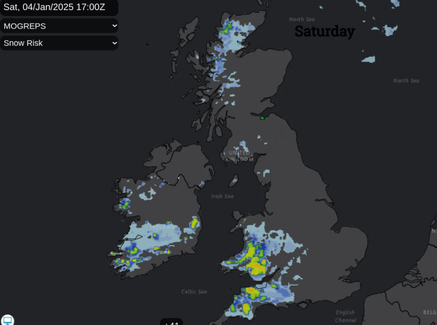
For London and the Home Counties, the weekend will turn more cloudy and feel cold by day. Any snow is mostly during Saturday night but will turn to rain by Sunday morning as the temperatures leap up and milder air follows from the southwest.
Birmingham will see a grey Saturday but it will be overnight when the wintry weather arrives. The snow could last into Sunday morning with possible disruption on the roads. It will turn to sleet and rain on Sunday but stay cold.
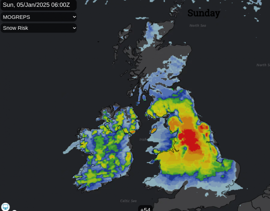
As other parts of the UK await a wintry spell, there are wide and lengthy Met Office weather warnings for Snow and Ice which were issued earlier this week but cover several days. Look out for updates if you are travelling this weekend. Half of the weekend will be fine for most and there will be a sunny gap between the snow showers in the far north, and the incoming wet and wintry weather from the south. A deepening low pressure will bring a significant change in the weather during the weekend. The Met Office likes the phrase “Multi-Hazard” and over the next few days, the forecast includes; severe frost, ice, freezing fog, heavy/drifting/blowing snow, freezing rain and more rain, as some areas already have sodden ground.
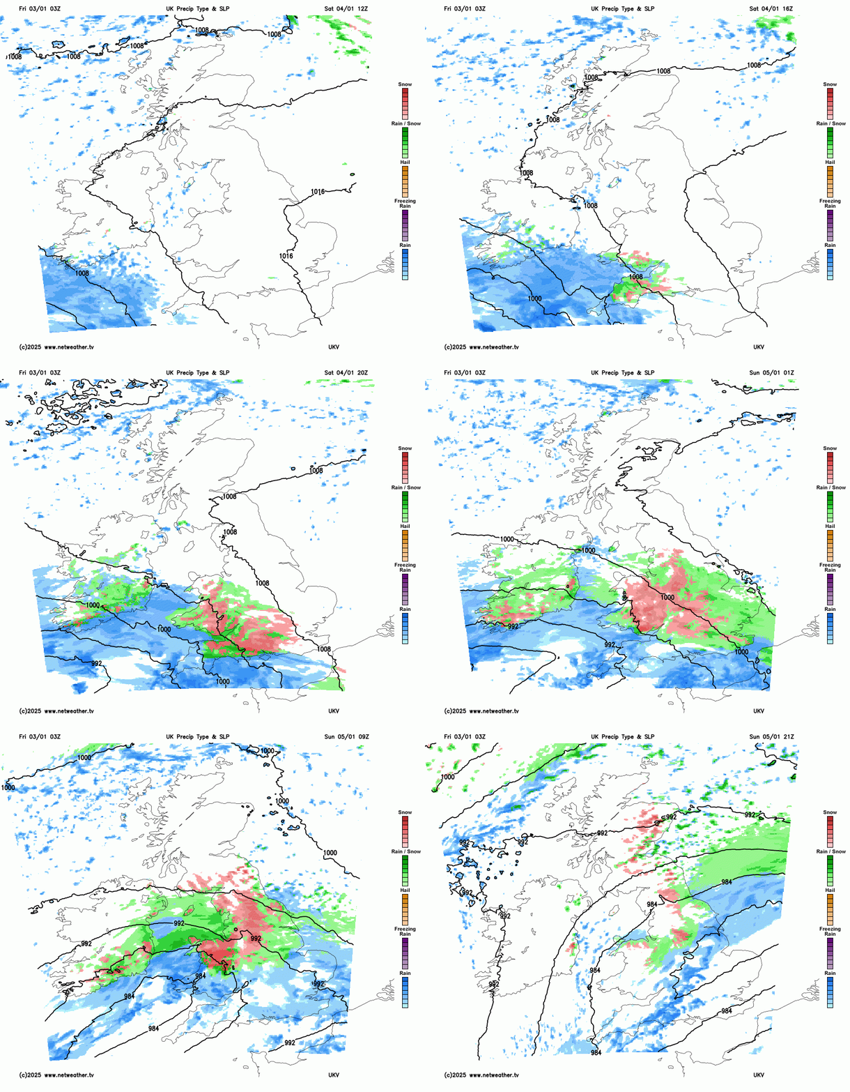 During Saturday the cloud will increase over southern Britain and the frontal precipitation is due to hit Cornwall, Devon and the south coast of Wales on Saturday afternoon. The rest of the weekend’s weather will be dominated by the progress of this wide area of rain, sleet and snow extending northwards. Snow, as it reaches that cold air in the north, and further south it will soon turn back to rain as mild air follows.
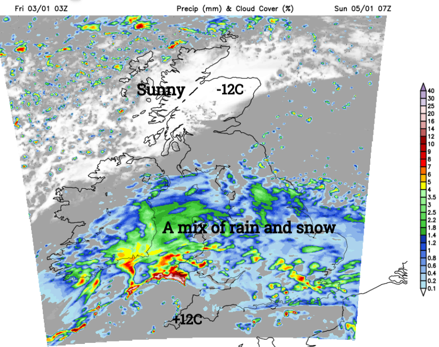
The UKV model by 7am on Sunday morning shows much of England and Wales covered by this wet and wintry mix. And yet to the north, the cold Arctic air holds on with sunshine, and a hard frost
If you are getting excited about sledging, there is hope, but it will be a complicated mix with snow falling after dark, or just being rather wet and slushy. North Wales, the Peak District into northern England, particularly through the Pennines, could see the best snow by Sunday morning. This wintry weather continues on Sunday across this central swathe of Britain, perhaps also reaching Belfast and eastern counties of Northern Ireland and the Isle of Man. Later the wintry weather should extend into the Southern Uplands before a showery flow of coastal rain showers off the North Sea but sleet and snow showers inland sets in for the end of the weekend for eastern Scotland. This is covered by a separate yellow warning
“Heavy snow on Sunday and overnight into Monday may cause some disruption” MO
This wintry showery flow will continue for the start of the working week over northeastern Britain and could extend southwards with snow for the North Yorkshire Moors, even wintry flurries to the Humber later on Monday.
Keep in mid this background picture of cold air with frost and ice and the gradual creep of this band of cloud, rain and snow from the southwest. Many people won’t see the wintry weather on Saturday, but southwest England and south Wales will see a change in conditions before dark. Through the West Country, towards Cardiff into Mid Wales the weather will go downhill on Saturday evening.
Today
There are clusters of showers caught in the chilly northwesterly breeze. For Northern Ireland and coming into north Wales, Lancashire and Merseyside with a mixture of rain, sleet and hill snow for the Cheshire Gap. Northern Scotland continues with its blanket of snow and ice after days of showers. Overnight snow has managed to reach a bit further in the cold air on a small frontal band from the north, into Lothian and Northumberland.
This will fade today and the winds will become lighter.
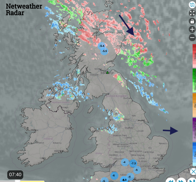
Netweather Radar at 0740 showing ten lowest temperatures, wind direction and wintry showers
Tonight will be cold, dry for most but with a scattering of showers from the west. There will be frost and ice and freezing fog in places. Northern Ireland also eastern England could see fog by Saturday morning, around The Wash into Norfolk. The frost for northeast Britain will be severe.
The Weekend
Later on Saturday, we see this deterioration in the weather from the southwest as the winds begin to strengthen, This will be quite a change after the cold, quiet spell. The winds will make it feel colder in the rain and sleet. There is the risk of freezing rain inland too, which brings a severe hazard due to sudden black ice on roads and pavements. In the cold air on Saturday night an easterly wind will pick up over southern Britain which will blow any snow about and could cause drifting over high ground where several cms of snow is possible.
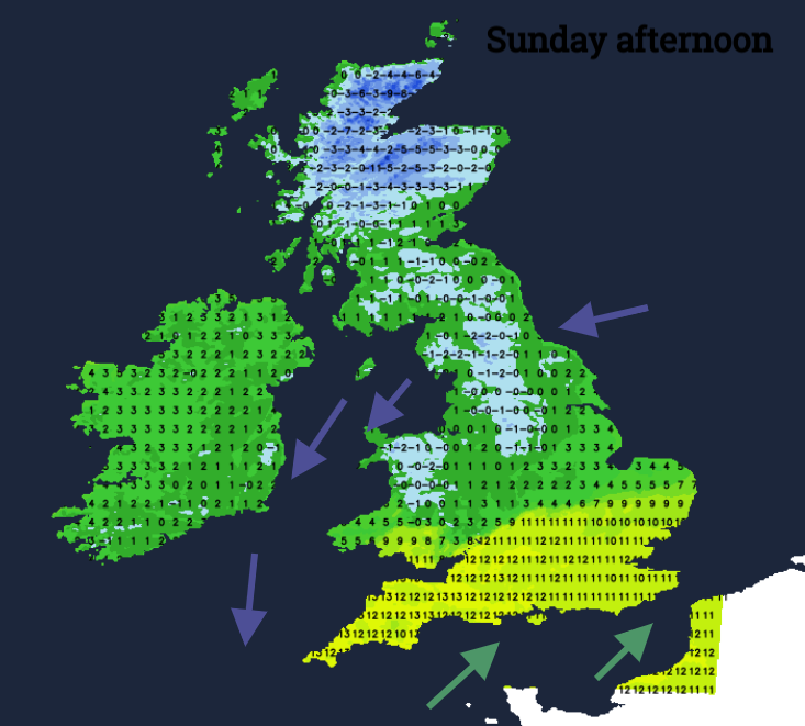
Milder air will follow with a brisk southwesterly wind as the deepening low pressure rotates over Britain and away over the North Sea by Monday.
Loading recent activity...