In last week’s update I noted that the forecast models were suggesting potential for northerly winds to establish next week, though at that time there was a lot of uncertainty over how much cold air would head south or whether or not it would hit the British Isles. As of today, the models have firmed up on this and suggest that we will indeed see a northerly outbreak, starting Sunday in the north, though the coldest air will take until Tuesday to reach the south.
Historically, snow in mid to late November has been fairly common, though it has tended not to stick around for long on low ground in most cases. 2010 was the last time that snow cover persisted widely on low ground for upwards of a few days in November, near the end of the month, which led into the record breaking cold December that year. Before that, we have to go back to the Novembers of 1993 and 1996. However, in more recent times sleet and snow fell quite widely to low levels in the Novembers of 2015, 2016, 2017, 2021 and 2023. In 2023, parts of northern and eastern Scotland and north-east England had a snow cover down to sea level from 30 November to 3 December inclusive. Thus, it is still fairly common to see falling snow in the second half of November and sometimes short-lived accumulations on the ground in spite of the warming trend in the climate.
There is currently still some uncertainty around the track of a frontal system moving across England and Wales on Monday. Some model runs have the majority of the rain over northern England and southern Scotland, where it would be pushing into cold air that is forecast to spread into these regions on Sunday.
This has potential to produce snow on the northern flank, particularly on high ground but also potentially at low levels away from the east coast. Areas near North Sea coasts will probably see rain from the system due to onshore winds off the comparatively warm sea. Currently the UKV model (animation below) still has the system tracking over northern England and the far south of Scotland. But there is also a chance that the system could push across the Midlands instead, bringing the possibility of snow over the Midlands, chiefly high ground but with potential for precipitation to turn to snow at low levels for a time as the system moves away and northerly winds set in.
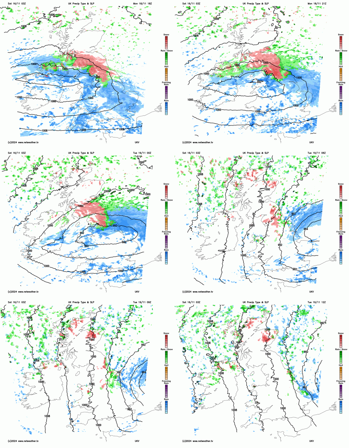
After Monday’s system, we will be in a cold bright showery north to north-westerly type from Tuesday to Friday. On Tuesday the winds will be northerly, and this means that North Sea coastal areas will see the majority of the showery activity. North-east Scotland can expect falling and lying snow to low levels. During Tuesday evening, a trough is forecast to bring showers a fair way inland over east Yorkshire and Lincolnshire and into the north and east of East Anglia, perhaps also heading into the eastern Home Counties for a time. Again, areas close to North Sea coasts will probably see mostly rain from these, but the showers are forecast to produce sleet and snow inland, with potential for accumulations to low levels locally, although substantial accumulations of snow are likely to be restricted to high ground, e.g. over the North York Moors and the Lincolnshire Wolds.
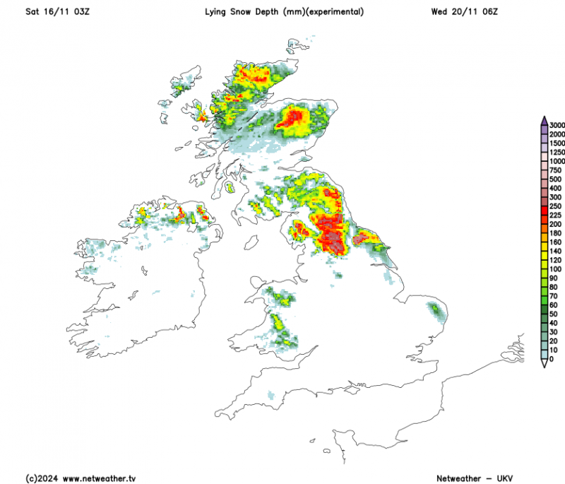
Between Wednesday and Friday, the winds are forecast to switch to a north-westerly direction for most of us. Northern Scotland will continue to see frequent showery activity. For most of the time the showers in northern Scotland will be of snow and hail, but a trough moving southwards overnight Wednesday/Thursday may introduce less cold air from a depression core for a time, turning showers back to rain and sleet at low levels, especially near coasts. Showers are likely to return to being predominantly of snow through Thursday and Friday.
Further south, the showery activity near the east coast of England will fade but we can expect showery activity to pep up in north-west England, north and west Wales and south-west England, with showers also funnelling through the Cheshire Gap at times, potentially penetrating through into parts of the Midlands and central southern England. In these regions, Wednesday will be the peak day for wintriness in the showers - snow may fall quite widely to low levels away from north and west-facing coasts - with the air mass turning a little less cold through Thursday and Friday, leading to snow being more restricted to higher ground.
While there is some uncertainty over how far north milder air will push and how quickly, the forecast models are suggesting that this will be a relatively lengthy cold snap for the second half of November, but that it will start to break down from the south next weekend as the Greenland/Iceland blocking high weakens and low pressure systems push in from the south-west. By next Sunday it is probable that the southern half of England and Wales will be in much milder air.
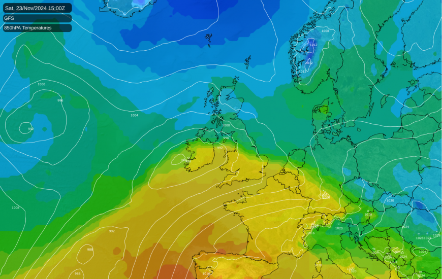
However, there is potential for temperatures to see-saw during the back end of November and into early December, with cold Arctic air repeatedly coming back south, especially into northern Britain, in between the depressions that push milder air north. Much of Scotland and northern England in particular has potential to see further snow at times from these systems, particularly when they push against this colder air.
Thus, while longer range signals are pointing towards a generally mild, changeable, westerly dominated winter in 2024/25, it could well get off to quite a wintry start in places, especially in the north. However, it won’t be quite on a par with late November 2010. A fair percentage of us will probably see some falling snow at some point during the rest of November, but a lasting snow cover at low levels looks unlikely away from northern Scotland.
Loading recent activity...