The Met Office have issued a number of rain warnings across parts of England, Wales and N. Ireland - as an unstable area of low pressure moves east across Wales and England - bringing increasingly frequent heavy downpours, with thunder in places, while showers could merge into longer spells of heavy rain.
A yellow rain warning is in force across eastern N. Ireland until 6pm today, a yellow rain warning is in force across NE England until midnight, while a larger yellow rain warning is in force across southern half of Wales, Midlands, southern England and East Anglia until 9am Friday, but within this yellow warning, there is an Amber Warning across the Midlands and western East Anglia.
Further detail on the Amber Warning from the Met Office states:
Slow moving showers and thunderstorms will develop through the afternoon, merging into a large band of heavy rain through the evening, before clearing slowly south overnight. Some places, especially across central and eastern parts of the warning area, are likely to receive 30-40mm in three hours or less, and perhaps 50-60mm or more in around six hours. This rain will fall onto already saturated ground and affect communities recovering from recent flooding. Travel disruption and further flooding is likely, with rivers continuing to rise after the rain clears.

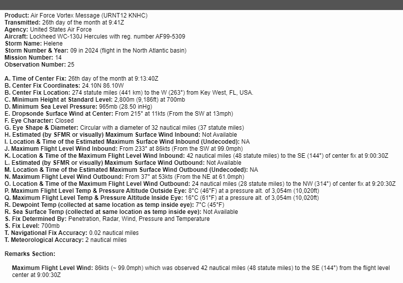
A tropical storm until yesterday afternoon, Hurricane Helene swamped parts of the Mexican Yucatan Peninsula on Wednesday, including the popular holiday destination of Cancun. Hurricane Helene will move north across the eastern Gulf of Mexico today toward an expected landfall over Florida's Big Bend Coast Thursday evening local time. Before landfall, Helene is likely to be a large major category 4 strength hurricane, with maximum sustained winds of 130mph with higher gusts. This will bring catastrophic winds and storm surge to the northeastern Gulf Coast, the National Hurricane Center (NHC) said. "Preparations to protect life and property should be rushed to completion."

Helene is likely to create a life-threatening storm surge as high as 15-20 feet (4.5 to 6 metres) above ground level along coastal areas in parts of the Big Bend region of Florida along the Gulf coast. There is also a danger of life-threatening storm surge along the remainder of the west coast of the Florida Peninsula. Residents in these areas have been advised by local officials to evacuate if told to do so. A storm surge as high as 15 feet or more is unlikely to be survivable for those that don’t evacuate their properties - unless they have a second floor, but even then, they may not be rescued for a while.

Potentially catastrophic hurricane-force winds are expected within the eyewall of Helene across the Big Band region of Florida, as the hurricane makes landfall tonight. So even well-built framed homes in the hardest-hit coastline communities may incur major damage or removal of roof decking, the NHC said. Many trees will be snapped or uprooted, blocking roadways. Electricity and water will likely be unavailable for several days to even weeks after the storm passes.
The damaging hurricane-strength winds and rain also could penetrate far inland, with the NHC issuing hurricane warnings well into Georgia. Also, tropical storm-force winds are forecast to extended as far as 345 miles from its centre, with tropical storm warnings as far north as North Carolina, while warning that much of the Southeast US could experience prolonged power outages, toppled trees and dangerous flooding.
Rain from Helene will also be a big issue. The NHC mention that heavy rainfall over portions of the Southeastern U.S. into the Southern Appalachians is expected to produce total rain accumulations of 6 to 12 inches with isolated totals around 18 inches. This rainfall will likely result in catastrophic and potentially life-threatening flash and urban flooding, along with significant river flooding. Numerous landslides are expected in steep terrain across the southern Appalachians.
Over the other side of Mexico along its Pacific coast, recently Tropical Storm John has been upgraded to a Hurricane over the eastern Pacific and is forecast to head back into Mexico again. John, which battered western Mexico as a Category 3 storm earlier this week, is expected to make another landfall. Hurricane John is over 150 miles west of Acapulco, Mexico, moving WNW at 3 m.p.h. It is expected to bring further catastrophic life-threatening flash-flooding and mudslides over southern Mexico over the next few days.

The storm has regained hurricane status before making landfall Thursday night local time near the southwestern city of Lázaro Cárdenas.

Back over to the Atlantic again, newly-formed Tropical Storm Isaac over the northwest Atlantic will move eastward and could become a hurricane too in the next couple of days according to the NHC. Issac will move over open ocean and unlikely to be a threat to land, though may skirt close enough to the north of the Azores to bring dangerous swell and waves to the islands later this weekend and into the start of next week. There is uncertainty where Isaac remnants go thereafter, once it becomes extratropical early next week. 00z ECMWF takes the remnant low towards Portugal, while GFS keeps it out over the Atlantic. GEFS storm track members take it on various tracks towards western Europe, including the UK, so we will be keeping an eye on where the ex-tropical storm low wanders!
Join in the discussion on Hurricane Helene over on the Netweather forum:
Loading recent activity...