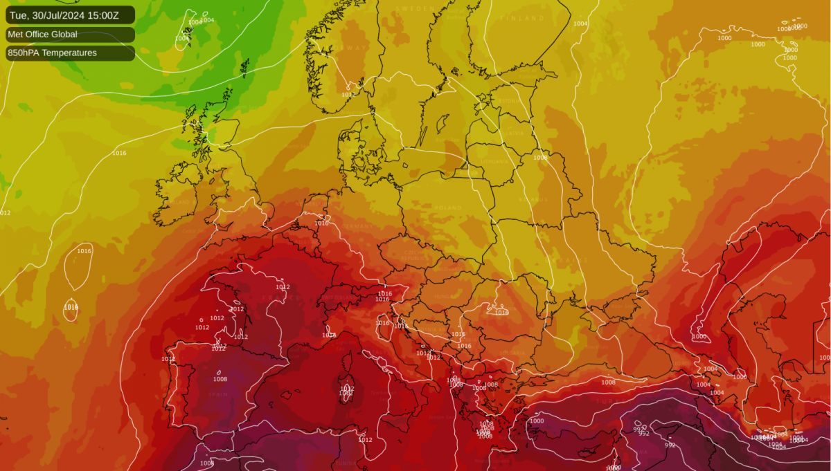
It is currently very hot in most parts of Spain and Portugal, with temperatures in parts of Spain having recently hit the mid-40s Celsius. It will remain hot in this region during the coming week, with potential for temperatures to peak at around 45C in the south again, especially on Monday. Towards the end of the week, the heat in Spain and Portugal will subside, especially in the north of the region, but the south can still expect maximum temperatures of around 40C.
A recent article in the Guardian has pointed out that this kind of heat is potentially dangerous to tourists who may be expecting hot and sunny weather in the Mediterranean but not quite this hot. There have been a few heatstroke-related deaths in recent times when holidaymakers went out hiking and ended up dying of heatstroke. In general, the Spanish are concerned that tourism, which has a history of being fuelled by the regular hot and sunny weather of your typical Spanish summer, may drop in the coming decades due to an increased frequency of excessive heat, which is one of many examples of where you can get too much of a good thing.
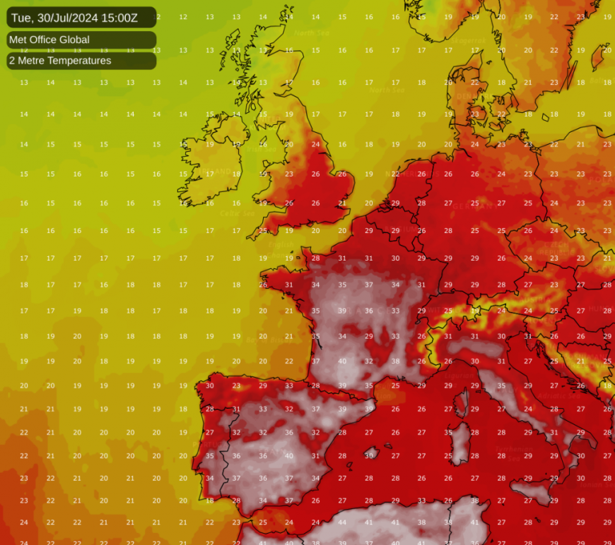
By Tuesday, this very hot air mass will spread to most of France, where inland parts of the south can expect temperatures of around 40C. It will not be as extreme in the north of France, but in the north temperatures in the low to mid-30s Celsius will be widespread. The hot weather in France will be somewhat briefer than in Spain, and by Thursday and Friday most of France can expect mid to high 20s Celsius.
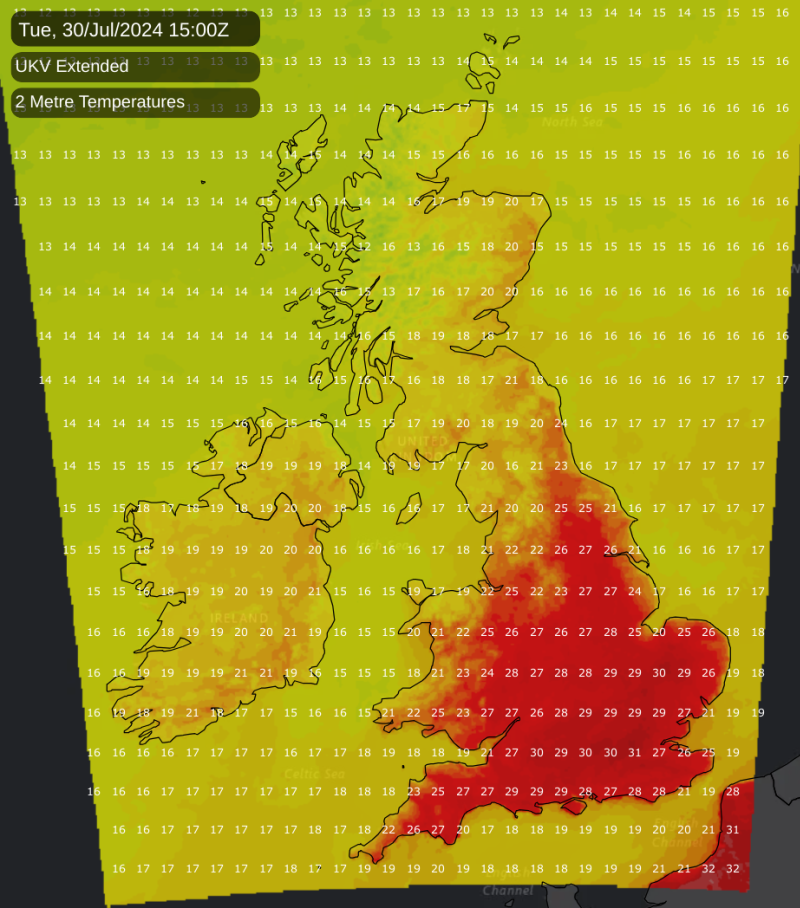
Meanwhile, Britain will continue to avoid any unusual heat for the time being, with none of this unusually hot air mass making it as far north as the British Isles. However, with a ridge of high pressure taking hold, it will get hot by most standards (just not unusually so for the time of year) early next week, particularly on Tuesday when maximum temperatures of between 30 and 32C are possible in the south-east. Scotland and Northern Ireland will tend to miss out altogether, with temperatures generally in the low 20s Celsius, which is a bit above the long-term normal for the time of year but not notably so.
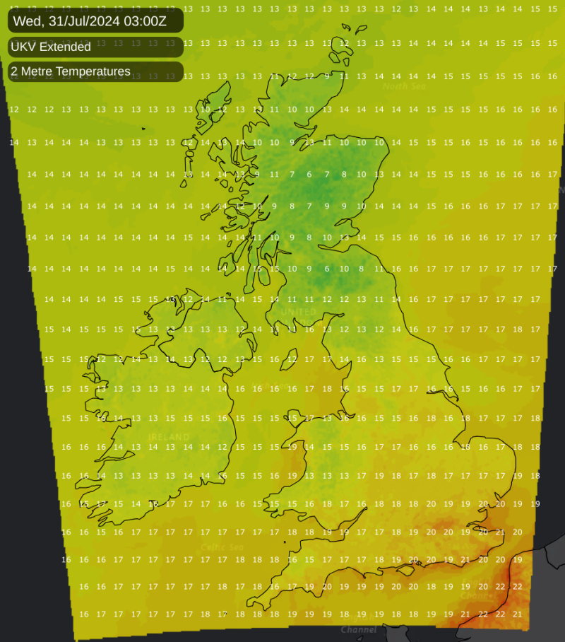
However, as has often been the case with summer hot spells in Britain in recent years, it will be notably warm by night at times. On Tuesday night into Wednesday, in the southern half of England, particularly the south-east, temperatures are forecast to get no lower than 16 or 17C, and may struggle to get any lower than 20C in urban areas (particularly central London), which will make cooling off and sleeping overnight difficult for many of us.
Thundery activity has so far been well down on the long-term average in most parts of Britain so far this summer, especially in the east and south-east of England (traditionally the most thunder-prone region of the UK). The decline in thunder frequency in many areas of the UK, especially towards the south-east, has recently been discussed in an article by Nick Finnis.
There is some potential for this to change from next Wednesday onwards, but no guarantees, as the forecast models, especially the GFS model, often overestimate convective precipitation and by extension thunderstorm potential at this range. As the hot spell of the next few days breaks down on Wednesday, there is potential for some thundery downpours to develop, especially in England. There are signs that a slow-moving low pressure area may move close to the British Isles in early August, accompanied by southerly and south-westerly winds, which has potential to bring some slow-moving thundery showers associated with the low pressure, as well as potential for some thunderstorms to move in from France, especially into south-east England. However, potentially thundery setups have so far generally delivered little so far this summer.
In most parts of the UK, the first half of July was unusually cloudy, and it was unusually wet for some as well, particularly in the east of England. Temperatures were about 2C down on the old 1961-1990 average (which is quite representative of the 20th century as a whole for July) and thus exceptionally cool for recent years. However, for many areas, a warmer, drier, sunnier second half looks set to ensure that the month as a whole will not be remarkable.
In the Central England Temperature series, the mean temperature for July as a whole is sitting at just 0.1C below the 1961-1990 average, which, with some hot weather coming up, looks set to push above the old average by the end of the month. It may still come in just under the most recent 30-year average (1991-2020), but it is looking probable that July overall will not be unusually cool even by recent standards. Many areas may well still see below-average sunshine and above-average rainfall for the month, but again generally not unusually so.
Loading recent activity...