Temperatures are on the rise and by early next week parts of southern Britain could reach 29 or maybe 30C.
Northern Africa is unseasonably hot at the moment and a pulse of heat has moved up into the central Mediterranean. Sicily, SE Italy and Croatia all have red high temperature warnings with wider heat warnings across Italy and the Balkans on Friday. There are also concerns about severe thunderstorms in the region today and on Saturday.
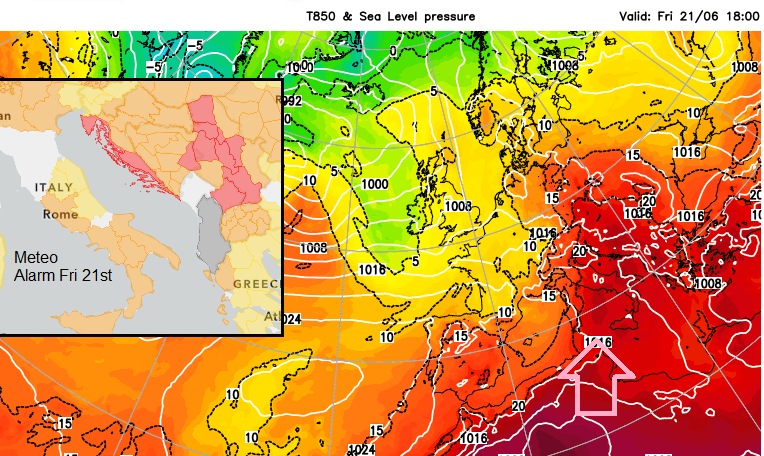
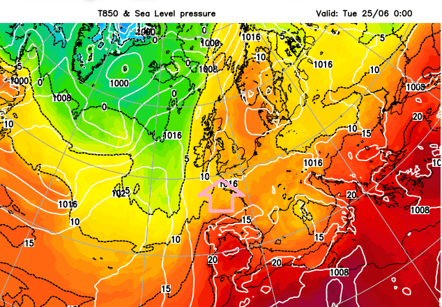
With the longest day yesterday and clear skies over England today, there are long hours of sunshine to heat the ground. Hull saw 24.4C on Thursday and temperatures on Friday could reach 25C in London, the Home Counties or eastern England. By Monday, very warm air will extend from Portugal and Spain towards the UK and then on to Scandinavia by Wednesday. The UK record for the month of June is 35.6C, so these are not extreme temperatures but it is certainly a change for much of the UK as we’ve not seen much proper summer heat so far. Even though the overall monthly temperature trend has been buoyed up by a lack of frost or cold nights in spring.
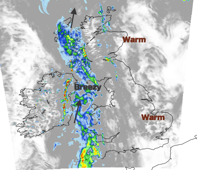
There has been glorious sunshine over England on Friday morning but more cloud in the north and west as a cold front approaches from the Atlantic. This continues to bring patchy rain over Ireland and a few showery bits for western Scotland. The frontal band will affect Northern Ireland on Friday afternoon and reach western Britain by this evening with the chance of thunderstorms for Ireland on the back edge of the front.
This cold front stumbles across England overnight, with lingering low cloud and a few bits of rain over eastern England, perhaps still the Pennines early on Saturday., Behind it will be fine and bright. Overall on Saturday, there will be a lot of fine and bright weather about but with a scattering of showers. There is a signal for showers from the Isle of Wight moving over SE England by lunchtime on Saturday and more showers for eastern England, particularly North Yorkshire. Then a lot of dry sunny weather with eastern counties slowly brightening up too. Later the next frontal band arrives for NW Scotland.
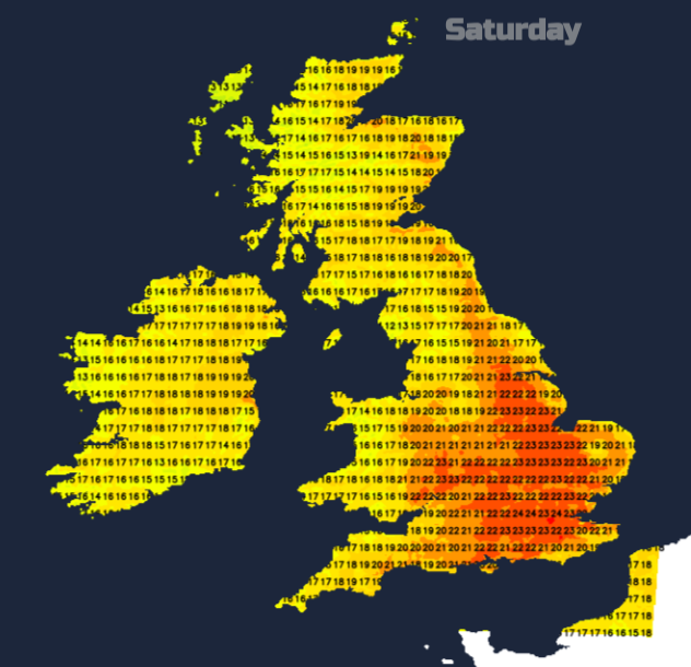
There will be a fresh southerly wind for the Western Isles as the rain arrives, moving into NW Highland by Saturday evening and trailing more cloud and dampness over Northern Ireland. This weather front weakens as it moves over Scotland during Saturday night, with damp weather around the Solway Firth and rain for the Cumbrian Fells.
By Sunday morning the winds will be light and there will be a lot of fine, bright even sunny weather and it will feel warm. The front will keep a good deal of cloud over Wales, the West Midlands and the West Country on Sunday morning even dampness for North Wales and Lancashire and coastal fog for SW England. It should thin and break up a bit, but also extend towards London for Sunday evening. In the sunnier southeast, it will feel very warm and humid and much of the UK will feel warm on Sunday.
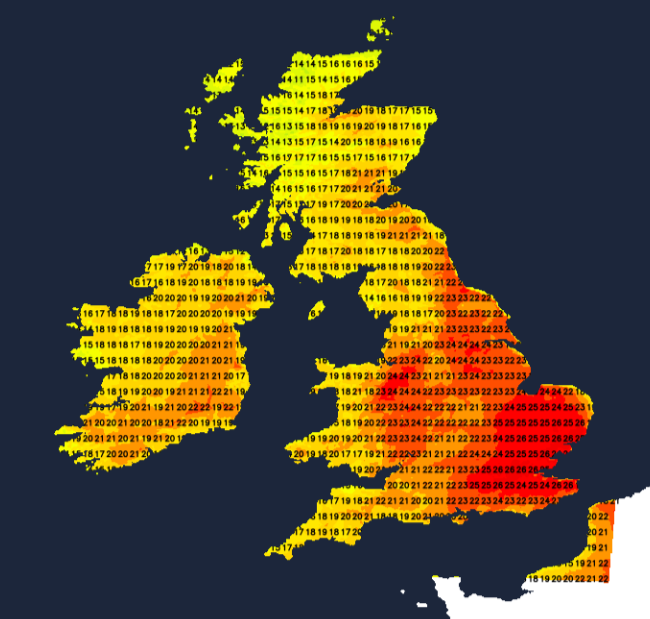
In a southerly flow for Monday, it will be hot with good sunny spells. All of England, apart from the Northeast, is under a Heat Health Alert from Monday 24th til Thursday 27th June. This is a forecast service created by the Met Office and UK Health Security Agency (UKHSA) but only for England. It is an alert for health providers about upcoming hot weather which could alter the demand for their services
“Minor impacts are probable across the health and social care sector”
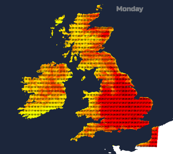
Showery rain will flirt with western Ireland and also the far northwest of Scotland but much of the UK looks hot and sunny for the start of next week. There are signs of heavy showers even thunderstorms breaking out on Tuesday night or Wednesday and then an Atlantic weather front sweeping in from the west on Thursday. So don’t expect the heat to last all week.
Loading recent activity...