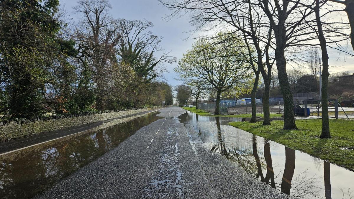
Spring tides and more rain add to the swamp-like feeling across the UK. There are flooded paths, and submerged fields but a bit of hope for later this week, in the south.
This week’s spring tides have added to the excess water around the UK. Travelling by train or road over the Easter holidays, you will likely have seen many flooded fields or the very high coastal waters yesterday, which return today. Footpaths have been muddy for months but some became submerged at high tide with numerous flood alerts.
The ground is already very wet and the additional rain with spring tides is increasing the number of flood warnings.
The Thames Barrier has been in operation again, protecting London from flooding from the sea. Southend saw its second-highest tide of the flood season so far, with the Barrier closing after forecast considerations about the low pressure over southern Britain on Monday night.
“Sometimes these [lows] can generate tidal surge through the English Channel rather than down the east coast… Potential for further closures over the next few days as the high spring tide period continues.” @AlanBarrierEA
The low pressure had been named Storm Pierrick by Meteo France. The combination of high tides and large waves with very strong winds was highlighted for the start of the week, along with thunderstorms inland. There was wild weather for NW France, SW England and through the English Channel with school holidays continuing for some. Wind and flood warnings are still in place on Tuesday for northern France.
In the wake of this low, the Environment Agency continues the risk of local coastal/tidal flooding until Wednesday in parts of England. "With local inland flooding is possible in parts of North West England on Tuesday. "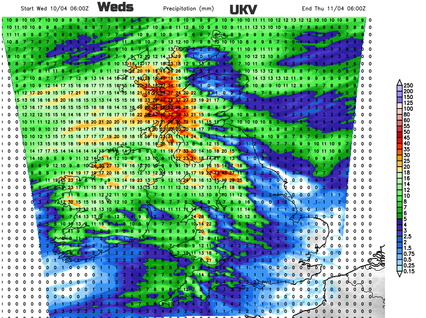
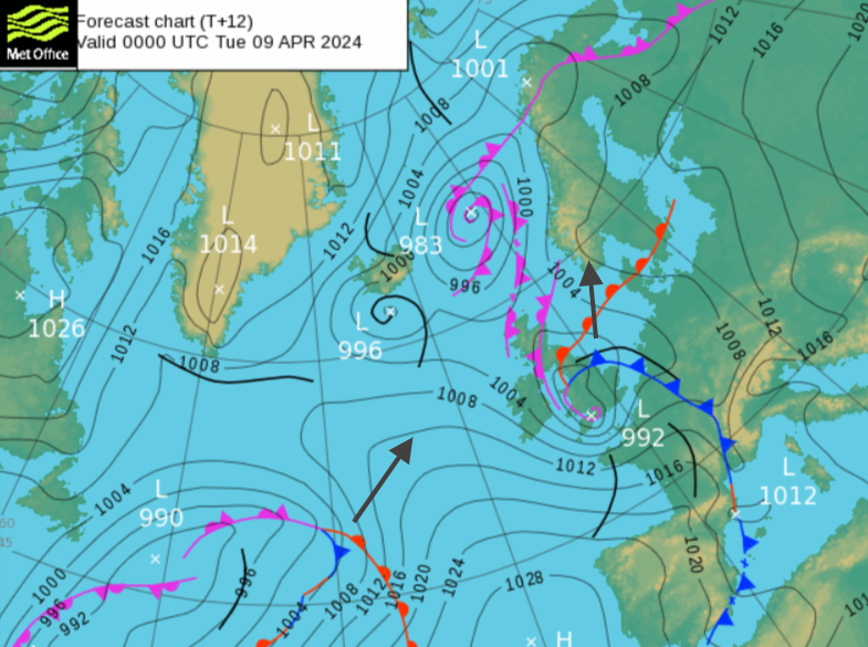
There were concerns for the Scottish Islands and East coast due to the high tides, surge and large waves in the wake of Storm Kathleen. That low pressure is fading away northwards over the Norwegian Sea but there are rain warnings from the UK Met Office for today and Wednesday.
SEPA “On Tuesday localised flooding from coasts is likely along the East Coast, the Western Isles and the Northern Isles. On Tuesday significant flooding from rivers and surface water is possible in southern, central and northeastern areas due to heavy rain. The area of greatest risk is in the south.”
Natural Resources Wales “Local coastal/tidal flooding is probable for parts of the Welsh coast..Tuesday and is possible on Wednesday.”
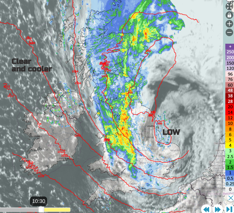
It’s raining again. An occluded band has brought heavy rain to Wales, edging further inland this morning with blustery winds. The rainband extended northwards across Scotland to the Moray Firth. There have been heavy downpours with a few thundery bursts offshore from Liverpool. The main rain area will clear away northeastwards today as the low centre pulls away from The Wash towards southern Norway. It will feel colder as a brisk northwesterly wind takes hold. It eases and backs to a westerly before midnight and there will be a brief ridge of high pressure over the UK for Tuesday night. Tonight will become dry and clear.
The next Atlantic low pressure will soon be on its way but there is a larger synoptic shift. Spain and more of mainland Europe now have high pressure, so there are drier and more settled conditions here than over the Easter weekend.
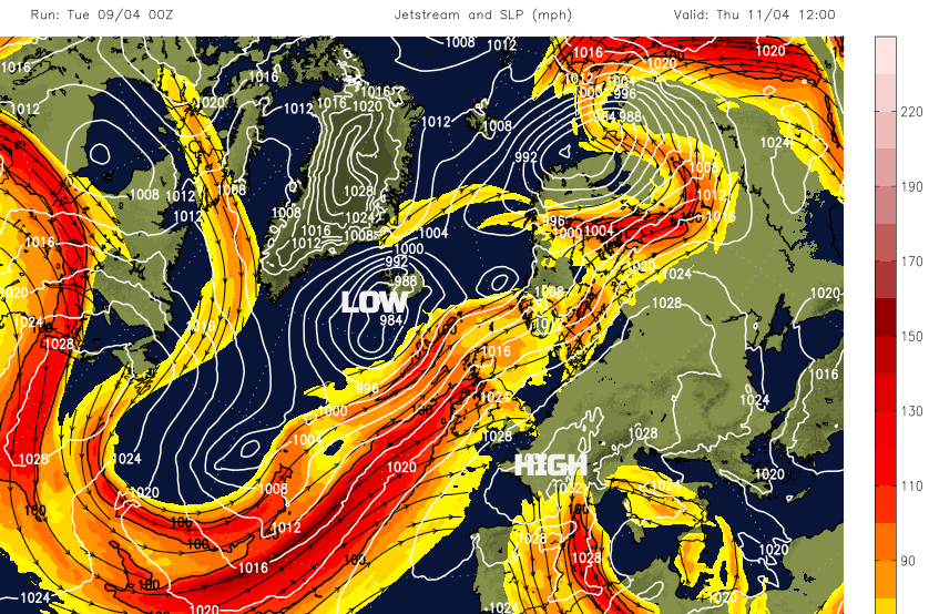
The jetstream is guided a bit further north, towards Northern Ireland and so the low centres run in between Iceland and Scotland this week. There will be a gradual change in the focus of the wettest weather, back to the more usual western Scotland, Northern Ireland, Cumbria and Gwynedd. And finally some drier weather for southern and eastern Britain.
On Wednesday a warm front will approach from the west with blustery southerly winds picking up. The frontal rain band will start the day over Northern Ireland and Cornwall and edge eastwards. Suffolk, Kent and London won’t see much from it. Western Scotland looks very wet with more rain for the western side of the UK. In the incoming warm sector, the milder air will be noticeable by the end of the day as the wind veers to the southwest. And by Thursday in a lighter westerly temperatures will be in the high teens for central and eastern England, so feeling warmer again.