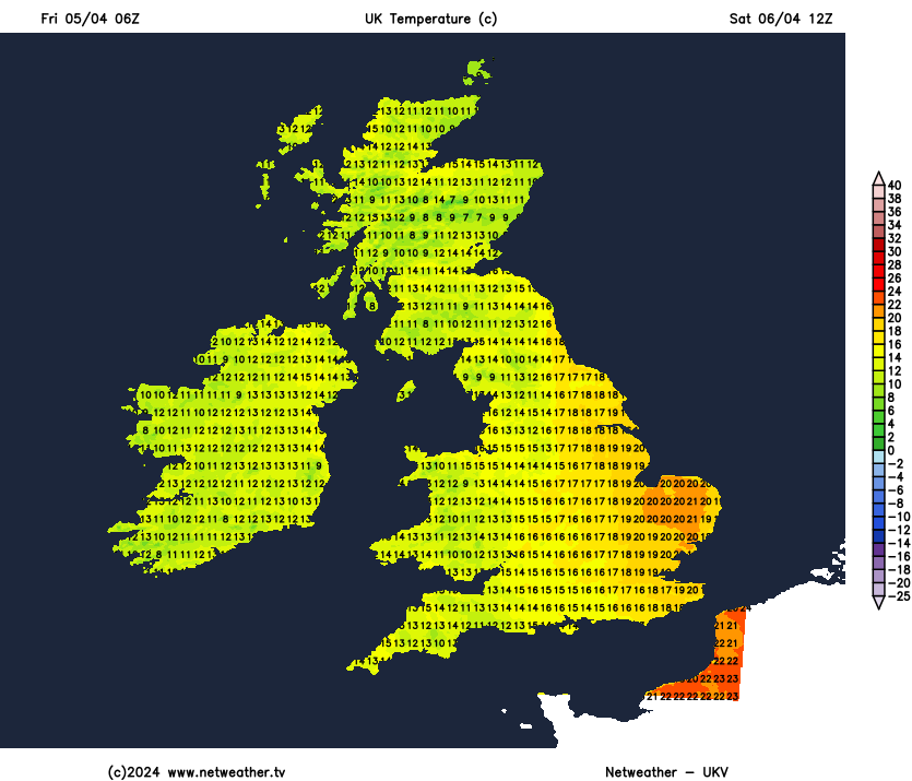
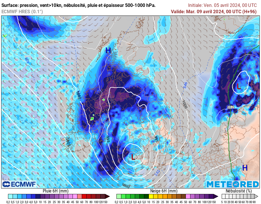
After a snowy start in Scotland this morning, turning milder and increasingly windy into the weekend as Storm Kathleen arrives to our west, bringing gales and rain to the west and warm air further east. Temperatures will reach 20-22C across eastern England.
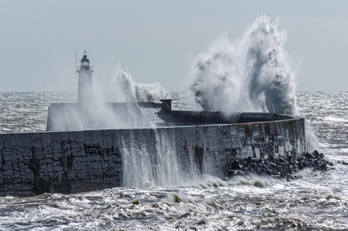
The UK is experiencing almost everything the weather can throw it to end the week and heading into the weekend. We’ve seen snow this morning across parts of Scotland, wet and windy weather elsewhere, more rain for many tomorrow but also some warm weather across eastern England, but last but not least - very windy conditions developing. The strong winds will be the most notable thing through Saturday, brought by Storm Kathleen, named by Met Eireann yesterday, which will track north to the west of Ireland. The storm will bring gales to northern and western parts of the UK, but the Republic of Ireland will bear the brunt of the strongest of winds nearer to Kathleen, with severe gales likely to develop towards the west.
Storm Kathleen is currently taking shape west of Iberia this morning. The low has a central pressure of around 969 hPa at the time of typing and will continue to deepen in the left exit of a strong jet streak crossing the Atlantic. The left exit of the jet stream features strong upper level divergence of air, where air fans out from the exit of jet stream. This causes a vacuum which forces air to converge and rise at the surface to fill this vacuum, in turn lowering air pressure at the surface.
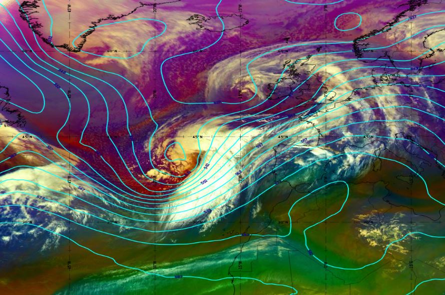
A dry air intrusion (dark stripe) and the upper air divergence (blue) already discussed are shown on the water vapour image below in the left exit of strong jet and will help the low deepen over next 36-48hrs, deepening to around 945-950 hPa by early Sunday, GFS forecasts the lowest central pressure.

As well as bringing gales or severe gales to the north and west tomorrow, Storm Kathleen will also drag very warm air north across England from NW Africa via Spain and France. The very warm plume could actually be record breaking for warmth in April at 850 hPa (1500 metres up). At the surface, no records look to tumble, but temperatures look to be well-above average towards eastern England, where they are forecast to reach 20-22C in the afternoon in any sunshine.
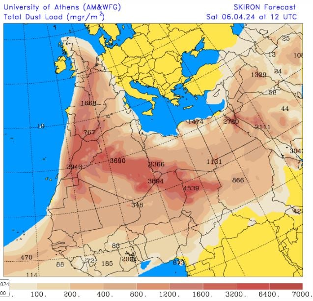
With the warm air being dragged north from Africa by Storm Kathleen will also be Sahara dust, so the skies may have an eerie hue to them too towards eastern England – where dust load is forecast to be greatest.
For now, large north-south contrasts in weather and temperatures across Britain to start this morning. Snowing across parts of Scotland first thing, mostly north of the central belt, while it’s much milder further south across England and Wales, with 13C to start day in SE England.
Many places have seen outbreaks of rain spread through overnight, this has cleared for most but will be slower to clear north across northern Scotland – where it will continue to fall as snow inland, before clearing north early afternoon. Following on will be a lot of cloud and scattered blustery showers or longer spells of rain for northern and western areas, sunny spells and scattered mainly light showers for southern, central and eastern parts. Feeling warm across England and Wales, despite the strong blustery southwesterly wind, temperatures reaching 14-16C, 17-18C towards eastern England where the sun comes out. Chillier across Scotland, temperatures reaching 6-9C.
Further areas of rain, locally heavy, will push north across western and northern areas tonight, accompanied by a strong to gale force southerly wind. Cloudy at first across eastern England, with the odd spot of rain or drizzle, but becoming drier and clearer later, windy here too. Very mild night across England and Wales, no lower than 12-13C in the south.
Storm Kathleen will slide north close to the west of Ireland on Saturday morning, with tightly packed isobars packing a punch of strong winds, with gales in the west, gusts reaching 50-60mph across western coasts and hills, perhaps up to 70mph with exposure along Irish Sea coasts. Windy further east too, with gusts in excess of 40mph possible. Overnight rain will clear north from northern Scotland during the morning, then for most its sunny spells but also some blustery showers across northern and western areas, southern and eastern areas of England staying mostly dry, fine and becoming warm – temperatures reaching 20-22C - making it the warmest day of the year so far. Elsewhere, still a very mild 15-18C.
Still very windy on Sunday, as Storm Kathleen tracks north to the northwest of Britain, strongest winds with gales across western Scotland. Sunny spells for most, but also blustery showers, heavy and thundery across western areas. Southeast may stay dry and sunniest. Not as warm, but still mild, temperatures reaching 13-16C.
Trouble brewing for the south on Monday?
Hot on the heels of Storm Kathleen another potentially rapidly deepening low could take aim at southern UK this time on Monday, which we are keeping a close eye on. This low crosses east across the north Atlantic over the weekend as a fairly shallow feature but then moves into left exit of strong jet streak, where it may rapidly deepen from Sunday before moving northeast into southern Britain on Monday – where it could bring gales to southwest and southern coasts and yet more rain.