It looks likely that low pressure will be in charge for the long Easter Weekend, so expect the weather to be unsettled with showers or longer spells of rain. However, it may feel pleasant in any sunshine that appears.
Easter last year saw some fine, sunny and warm weather through until late on Easter Sunday, after which, cloud and rain moved through from the west. This coming Easter Weekend could be a more unsettled affair, thanks to low pressure being modelled close by. There is some uncertainty this far off being 7 days and more away, but it looks like the areas of low pressure that move in and hang around close to the west and southwest next week, bringing unsettled and breezy conditions, will also hang around close to the southwest into the Easter Weekend. One positive, though, is that models are showing winds being drawn in from the south or southeast, so if the sun comes out – it could be pleasantly warm.
Looking at the synoptic evolution over the next 7 days or so that seem to point towards an unsettled Easter Weekend, the models indicate a strong jet stream emerging out of NE Canada extending southeast across the North Atlantic down towards Iberia early next week.
This jet extension towards Iberia occurs in tandem with an upper vortex of cold air over Labrador Bay between Canada and Greenland moving southeast to settle close to the west or southwest of Ireland from mid-week. An area of low pressure collocated with the upper low also moves in the same direction. Some disagreement between models on where the low pressure system moves and settles later next week, ECMWF and UKMO settles the low just west of Ireland, while GFS takes it the southwest of Ireland.
.png)
Wherever the low ends up, it will become increasingly unsettled through next week, with spells of rain or showers affecting most parts everyday next week, but some sunny spells thrown in too. The timings of more organised areas of rain moving through uncertain for now.
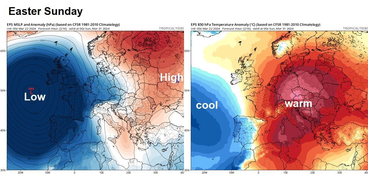
By Good Friday, it looks likely low pressure will be close by, centred near Ireland, the low pressure system not really moving very far over the Easter Weekend too, looking at ensemble guidance from GFS and ECMWF. So, we can expect unsettled conditions to continue over the Easter Weekend, with the risk of showers or longer spells of rain for most. However, models suggest the wind is predominantly likely to blow from the south or southeast during much of the Easter Weekend. A mild direction, so where the sun does come out, which is likely between showers and away from organised cloud and rain areas, then it could feel pleasantly warm.
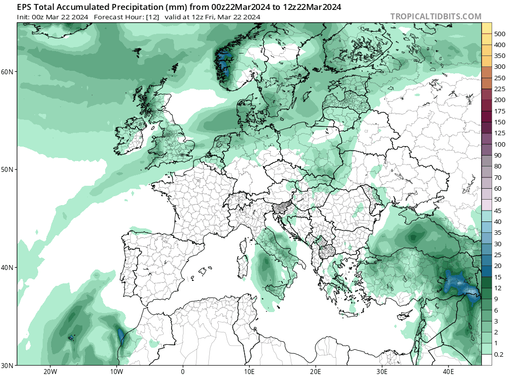
The prospect of rain everyday next week and potentially everyday over the long Easter Weekend is probably not what you want to hear. The additional rainfall from showers or longer spells of rain falling on already saturated ground will quickly lead to river levels becoming high and at risk of overtopping banks and causing flooding, while groundwater levels in chalk aquifers in England are very high too, so may also cause some minor flooding to property. The animation of rainfall accumulation below shows there could be quite a wet period, especially in the west, between the start of next week and the end of the Easter Weekend.
If you are lucky enough to escape abroad for the Easter Weekend, prospects, at the moment, aren’t looking much better if you are headed to Spain or Portugal – where the strong jet stream will be aimed at flowing all the way down from NE Canada. So much of Iberia is looking unsettled and cool, with spells of heavy rain or showers moving through, could be quite windy too towards the Atlantic coasts. Still, the rain will likely be welcome in the very dry southern and eastern parts of Spain – which have had a very dry winter, if much rain reaches here.
Those headed to central or eastern Europe and southern Europe from SE France and Italy eastwards will have much better prospects, with high pressure building from the south for the Easter Weekend. After some unsettled weather next week, turning drier with warm sunshine developing looking most likely, perhaps very warm, looking at ensemble temperature anomalies.
Although it is looking unsettled, for now, across many parts of the UK for the Easter Weekend, where the sun does appear, it should feel pleasantly warm. So it could be worse, especially as some Easter Weekends in the past have even seen snow. 1975 saw a snowy Easter, with 15cm of snow in Birmingham on Maundy Thursday. 1983 saw a cold and snowy Easter, with north winds bringing settling snow as far south as Kent on Easter Sunday (3rd April). Some places saw a white Easter in the middle of April in 1998. Snow fell in the north and east over Easter in March 2008. Easter falls on the last day of March this year.
The Met Office say it has snowed for more days on average in March than it has December. On average, snow or sleet falls for 3.9 days in December, while in March the average is slightly higher, reaching a total of 4.2 days. So, you could say snow is more likely in a March Easter than Christmas.