With peak spring tides this week there have been coastal and tidal concerns with sodden land and high river levels. More rain as we look to the weekend.
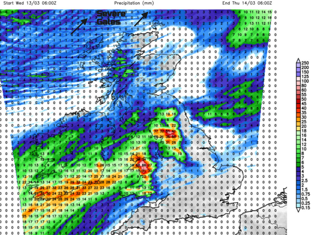
We have a series of low pressures influencing our UK weather for the rest of this week. On Wednesday, one moves between Iceland and Orkney towards the Norwegian Sea with severe gales for northern Scotland by lunchtime. This low creates a slight surge down the North Sea adding to the push onshore of the current large tides, the peak period of the equinox spring tide. There are coastal flooding concerns, particularly for the Scottish Islands.
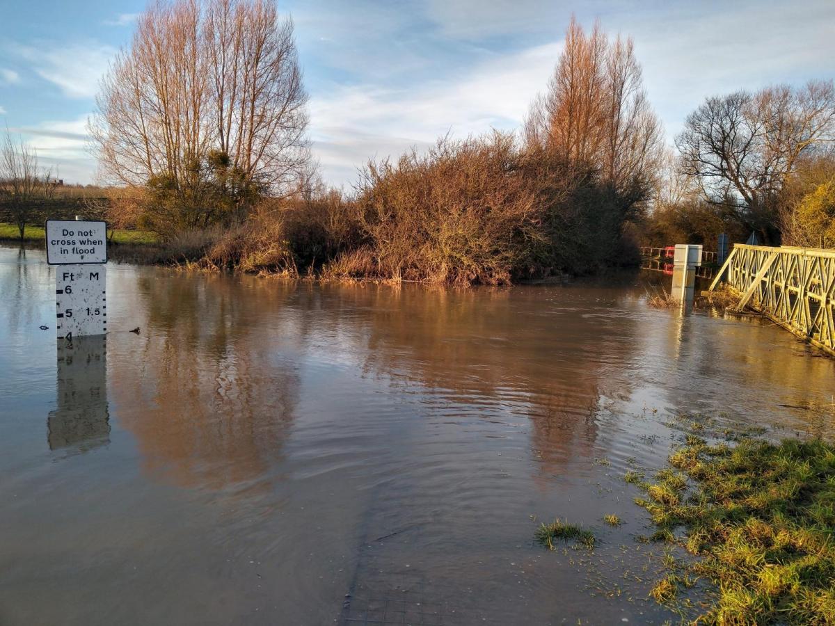
By Thursday, the trailing air mass boundary divides cool air over northern parts but a very mild flow from the south/southwest. This will lift temperatures into the high teens for London and the Home Counties. Along this frontal line, another low centre develops over Ireland then Scotland later on Thursday bringing rain. For England and Wales, there will be blustery winds with sharp showers from the west. Some of these could reach Cheltenham on Thursday night before the Gold Cup horse race. The going is already Soft/Heavy in places. Much of England and Wales is waterlogged. It has been so wet for so many months. There has been exceptional rain, with the wettest February on record for southern England and East Anglia. The winter months have also been wet, for England and eastern Scotland. The river levels are high, the groundwater levels are also high, and we have these big spring tides and just so much water around.
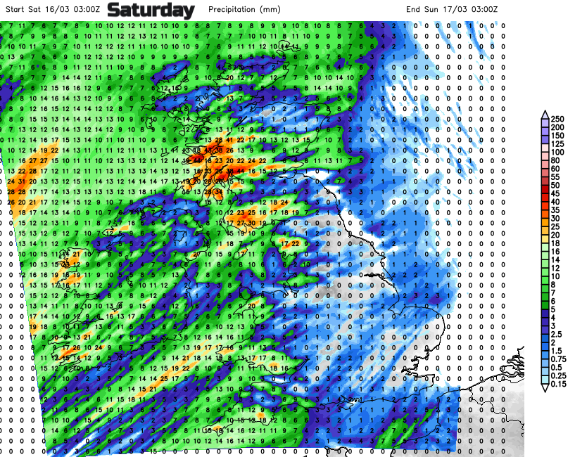
The occlusion from the second low will pull southwards on Friday, away from Ireland and slowly down Britain. This allows colder air to flow down from the north ready for a clear Friday night. Next, a large Atlantic low pressure begins to edge towards the UK at the weekend. This will bring more widespread rain, heading northeastwards through Saturday along with milder air. It clears to a cooler Sunday with bright spells but plenty of showers from the west.
“Low pressure will tend to raise sea level and high pressure will tend to depress it.” High pressure over southern Europe has been helping the peak levels in England this week but the Environment Agency are watching the mid-week northern low. The Thames Barrier may be in operation. Water levels adjust slightly over large areas and take time to respond to large-scale pressure influences but “when mean sea level is raised or lowered by strong winds or by storm surges, this effect can be important. “ National Oceanography Centre
It’s looking very changeable. There will be a quiet start to the weekend as the showery outbreaks of rain clear away late on Friday. There is this tuck of colder air from the northwest later on Friday with a touch of frost possible for Friday night. This is the coldest part of the weekend. The cool start on Saturday morning will be offset by bright even sunny skies for Scotland and central/eastern England. Next, rain will arrive for Northern Ireland and then Wales on Saturday morning, marching its way into western Britain after lunchtime. Then a mild mixed Sunday with a southwesterly breeze.
There are concerns of wave overtopping, large waves for North Sea coasts and southwest England with ongoing groundwater flooding inland this week. There are also coastal and tidal flooding concerns for Wales and western England today. The unsettled weather sits against a backdrop of months of wet weather for England.
The wild conditions for the far north of Scotland will ease away tonight. The frontal boundary rain will soak north Wales and northwest England. Looking very wet for Snowdonia, the Peak District, the Pennines, Yorkshire Dales and the Cumbrian Fells. There will be further outbreaks of rain on Thursday, particularly in the north and west
With further outbreaks of rain to come, do take care if you are out and about at the weekend. Rivers will be swollen and banks slippy. Take note of tide times and realise there is a large tidal range this week which will reveal more of the shore but also see the sea rushing in as it turns. Conditions under foot remain sodden with plenty of standing water and mud.