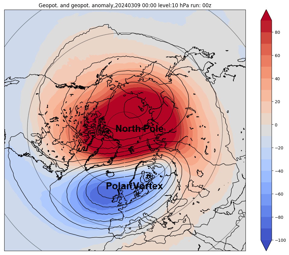
A Sudden Stratospheric Warming (SSW) event is underway – the SSW technically began on Monday with winds at 10 hPa 60N reversing from westerly to easterly. This reversal of winds down through the top of the stratosphere is marked by temperatures rising rapidly here, with the Polar Vortex collapsing and initially being displaced towards Europe. But eventually there are signs that the displaced polar vortex will go on to split into two daughter vortices. A split increases the chances of blocking high pressure developing at high latitudes – which then increases the chances of cold arctic air being flushed down into Europe.
However, any potential for colder weather patterns developing to affect the UK depends on many uncertain variables of where the polar vortex is displaced or, if there is a split, where the two vortices move and whether this is mirrored in the troposphere pressure/height patterns through coupling between the stratosphere and troposphere.


This is now the 3rd SSW this year in as many months, there was a brief reversal in January, before the polar vortex bounced back and westerly winds recovered again, then another brief SSW on February 19th occurred before winds recovered again, though it’s debatable whether it will be classified as a major or minor event.
The stratospheric winds at 19 miles altitude have reversed direction and now flow east-to-west. Winds that are blowing east-to-west essentially act as a roadblock to large atmospheric waves that occur during major warming of the stratosphere. So, the next big wave that tries to travel into the stratosphere will hit this roadblock, and the wave will break, slowing or reversing the winds just below the initial wind reversal that occurred at 10 hPa level on Monday. Then it’s a case of rinse and repeat: with the next wave hitting the roadblock of east-to-west winds slightly lower than before, slowing the winds at the next level down, until the reversal way up in the mid-stratosphere works way down to the bottom of the stratosphere.
The breaking waves also accelerate the transport of stratospheric air that sinks over the pole, which causes the air to warm and to build up atmospheric pressure. This leads to a rapid increase in atmospheric thickness over the polar cap that occurs shortly after the SSW at 10 hPa (19 miles up in the atmosphere). This increase in atmospheric thickness descends to the lower stratosphere over a period of days to a couple of weeks. Once the wind reversal in the middle stratosphere works its way down to the tropopause, where our weather occurs, how it affects our weather become less clear. This is because the increased atmospheric thickness over the pole becomes intermittent once it reaches the troposphere and tends to ‘drip’ down here. These drips correspond to enhanced high pressure over the Arctic which can push the tropospheric jet stream southward, but the dripping down of increased atmospheric pressure from the stratosphere is not consistent in timing or magnitude from one major SSW to another.
So, although downward reversal of winds in the stratosphere are usually fairly predictable following a SSW, often for several weeks following a major warming, antecedent weather patterns in the troposphere can either enhance or interfere with the downward drip of higher atmospheric heights following a SSW. This makes each SSW unique on its impact on the troposphere and weather patterns. Around 66% of them lead to colder conditions, so not all SSW events lead to cold. We all know the SSW in early February 2018 triggered the Beast From the East. But following more recent SSW events that occurred in January of 2019 and February of 2023, there was little impact on the weather for the UK and NW Europe in bringing cold and wintry weather.
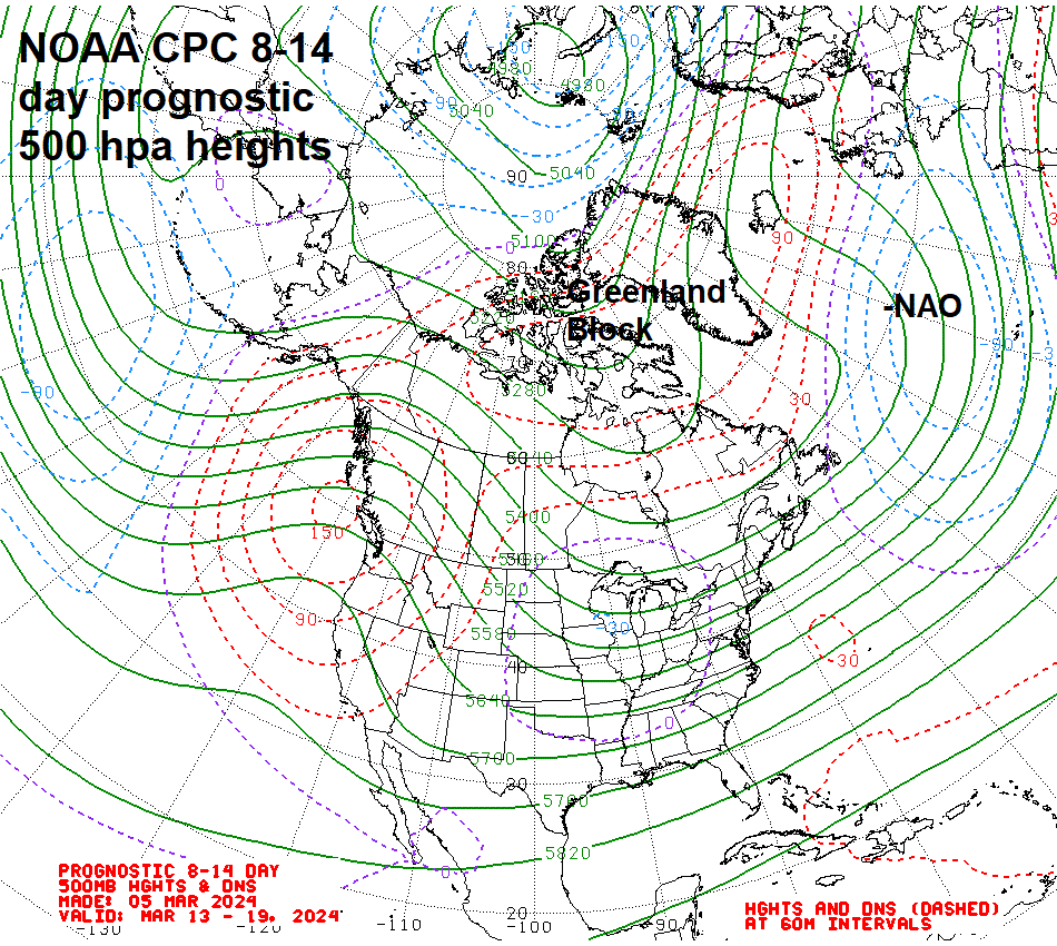
All that said, there appears to be strong warming in the lower stratosphere – which looks primed to drip down into the troposphere over the coming few weeks.
There is a signal from medium and extended range modelling for blocking high pressure over Greenland in the next few weeks too, likely in response to the SSW propagating down to the troposphere. Blocking to the northwest could increase the chances for colder conditions to invade northern and western Europe, as winds turn easterly or northeasterly at times, pulling in colder air from Scandinavia and NW Russia. While it turns increasingly mild or warm across SE Europe. But given it will be late March that the blocking looks more likely to develop, the chances for wintry weather will be diminishing. Though it can still snow in early April in southern Britain, more especially at night. It is ironically more likely to snow in Easter than Christmas if Easter falls in late March. But snow tends not to hang around as it quickly melts during the day away from higher ground in the north.

No sign of any wintry weather on the horizon. High pressure over Scandinavia looks to dry the weather out for the rest of the week, before low pressure nudging in from the southwest brings a return of spells of rain for many through the weekend. It look to turn increasingly unsettled through next week too, as areas of low pressure over the Atlantic make slow inroads from the west, after a dry start to the week. Temperatures look to be around average rest of this week and into the weekend, with a risk of frost overnight before the weekend, before temperatures rise slightly above average next week.
Any colder conditions that could be brought on by the SSW probably unlikely until sometime in the 2nd half of the month, if high latitude blocking takes hold to the north and positions favourably to push cold air into northern Europe. This very much depends, as mentioned at the start, whether the stratosphere is mirrored in the troposphere and if it is, where any blocking positions in relation to postion of areas of high pressure and low pressure in the stratosphere, which depends on where the displaced polar vortex or split vortices drift.
But the SSW increases the risk that any gradually warm up towards April may be subject to set-backs, perhaps dramatic, with a cruel reminder of winter not yet done at some point in the coming weeks.
Loading recent activity...