It's been very mild recently, especially across England and Wales, with temperatures well above average. However, a change is on the way to wetter, windier and eventually colder conditions. But temperatures returning to average rather than anything particularly cold or wintry.
Yesterday marked 2 years to the day since Storm Eunice, which struck southern Britain on 18th February 2022. The worst of the winds were across southern England and south Wales, widely there were gusts of 80mph, with a top gust of 122mph at the Needles Old Battery on the Isle of Wight, which set a new England gust record. Many stations in England recorded their highest February gusts since 26 February 1990. Two rare red wind warnings were issued for the southwest and southeast, with an amber wind warning covering much of England and Wales.
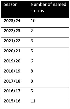
We have yet to see a named storm this month. The weather over northern Europe has been fairly benign this month since Storm Ingunn brought very strong winds to Norway and the far north of Britain on January 31st and Storm Jocelyn brought strong winds more widely across Britain on the 24th January, with a gust of 97mph in north Wales.
Jocelyn was the last Met Office / Met Eireann named storm and the 10th named storm of the season coming hot on the heels of Isha, which brought a just of 107mph on the Tay Bridge, Dundee and unfortunately claimed the lives of at least two people.
Since August, we have had at least one named storm a month affecting the UK. December brought three and there were three in January: Henk, Isha and Jocelyn. You could make this four if you include Ingunn, but that was named by the Norwegian Met Service. There hasn’t been this many storms, 10 so far, since 2015/16 season, when storm naming began
Although low pressure has generally been in charge since the beginning of the month, bringing rain at times, we have generally escaped storms bringing widespread gales so far this month, thanks to a fairly weak jet stream which has also generally steered away from the UK. It’s also been incredibly mild too for the first half of February, not just here but across much of Europe away from Scandinavia, thanks to predominantly south to southwesterly winds. The rolling England average temperature is currently +3.4C above the 1991-2020 average and the Central England Temperature (CET) some 4.8C above the 1961-1990 average up to the 18th.
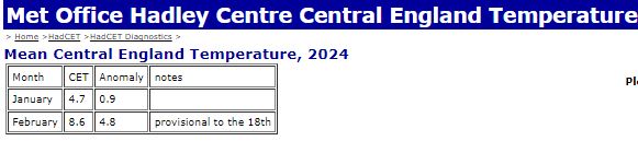
Met Office Hadley Centre CET data here
However, a pattern change this week will usher in chillier polar maritime air, windier and wetter conditions, driven in by a powerful jet streak upstream over eastern USA, fuelled by a steep temperature gradient, moving across the North Atlantic towards the UK. Though, for now, there is no model consensus any of particularly deep lows modelled that may need to be named. But we will be keeping a close eye any developments.
.gif)
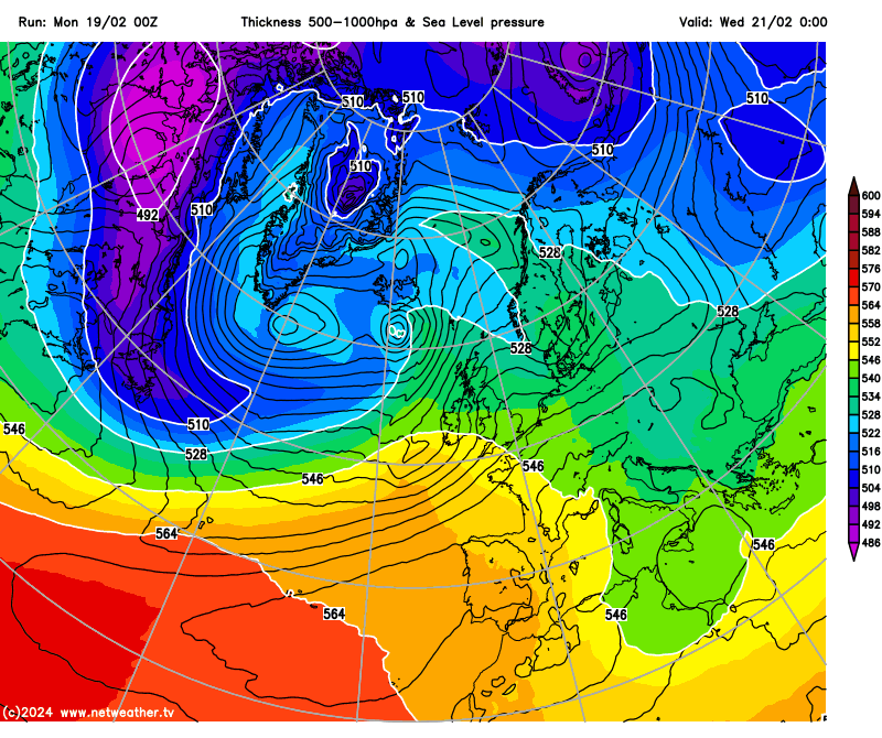
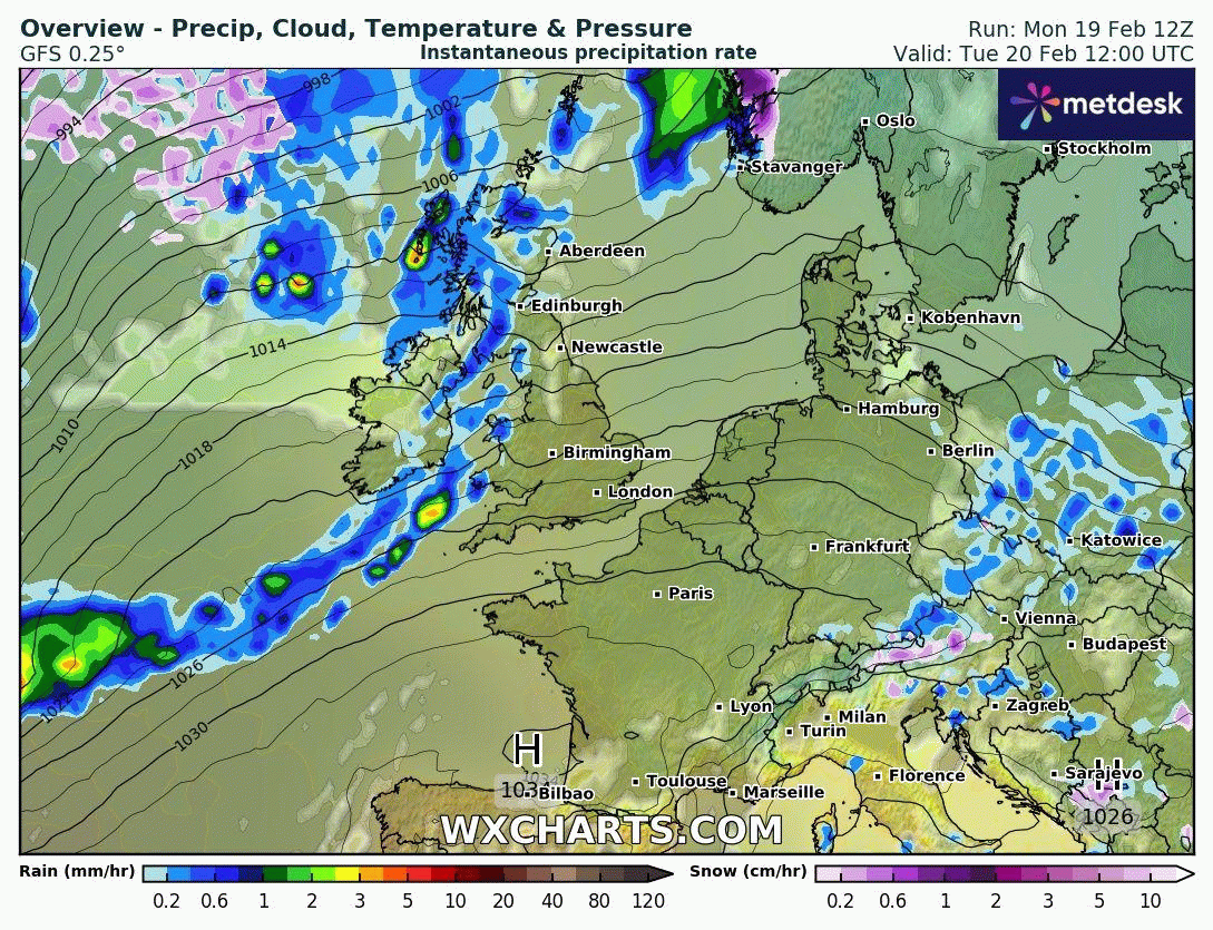
The strong jet stream initially takes aim at the UK, bringing waves of heavy rain Wednesday and Thursday, before the jet stream shifts further south to end the week, taking more persistent areas of rain further south but leaving UK in a cold and showery airstream.
Satellite image below shows a large low pressure system centred just south of Greenland, and frontal system ahead of it and trailing to the south all the way west then southwest to Florida. The large low south of Greenland will slowly drift east and become absorbed by a new low that develops to the south over the North Atlantic - which is forecast to deepen as it heads northeast then north close to Iceland on Wednesday. This will then form a large ‘parent’ low pressure system close to the north of Britain later this week.
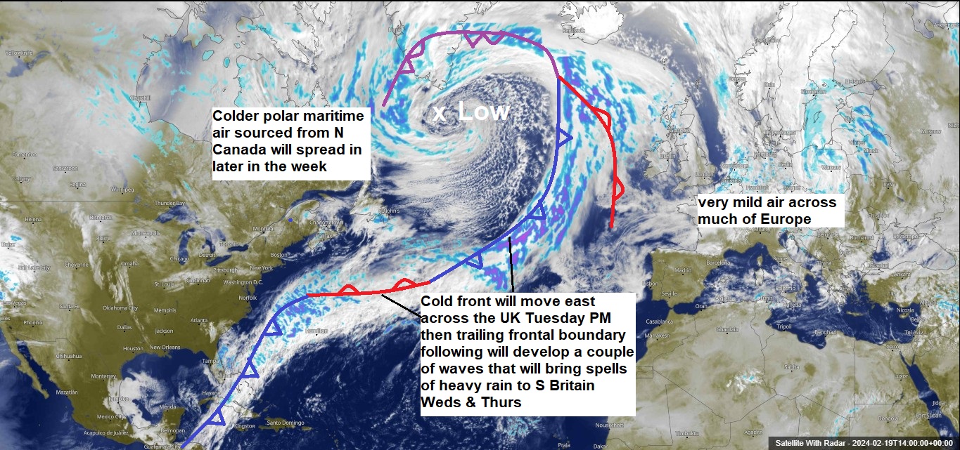
To the south of the parent low currently over the NW Atlantic, a powerful jet streak off the eastern seaboard of the USA, formed from the merger of a northern branch of the jet stream from Canada and stronger southern branch of the jet stream moving up from Florida, will plough east across the Atlantic over the next few days. A trailing frontal boundary – which trails west and southwest all the way to Florida and Cuba will parallel the jet stream above and will push east as a cold front during Tuesday afternoon and evening, bringing a band of rain with it. The front will trail across the south though Tuesday night, with small ripples or shortwaves developing in the jet stream above leading to waves developing along the frontal boundary trailing west out over the Atlantic.
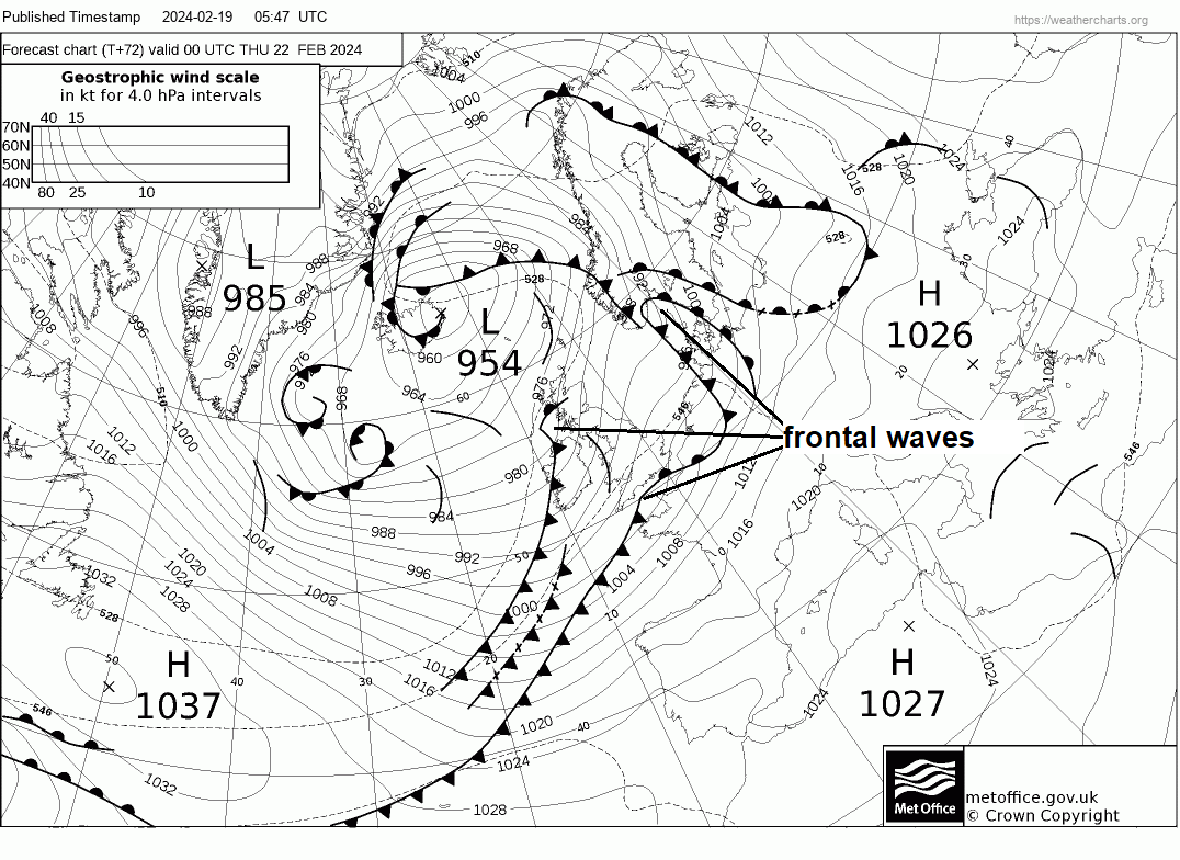
One of these waves and associated shallow low looks to push northeast across England and Wales on Wednesday, bringing a spell of heavy rain. A yellow rain warning has been issued by the Met Office for SW England. Another frontal wave and shallow low may follow across southern areas on Thursday, bringing further rain to already saturated ground and into already high rivers. So we may see an increasing risk of flooding by the end of the week.
By Friday, it looks to turn showery and colder for all – as colder Polar maritime air all the way from northern Canada spreads in, though the airmass will be well-modified, with temperatures generally returning close to average for many, perhaps below across the northwest and far west closer to the source of the colder polar maritime airmass. It could be cold enough for snow to fall from showers over higher ground of Ireland, northern and western Britain. It will be rather windy, too, later this week and into the weekend, with gales around western coasts and over hills, so it will feel colder than the thermometer suggests.