Despite signs at the beginning of the month that February would turn cold, now it looks like it will remain mild for much of the month. However, an SSW is likely in a week's time, and this could lead to this winter having a sting in its tail.
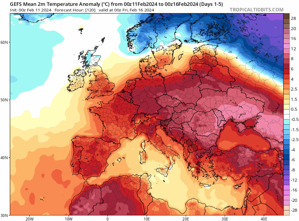
At the beginning of the month, extended model guidance had a persistent signal for cold weather to spread south across much of Europe, including the UK, from this weekend and persisting for a while. The signal was across all model output for a time, with high latitude blocking developing, particularly towards the northwest, which would pull cold arctic air south across Europe. But there was then a change away from the colder outlook and now it’s looking likely the next week or two will be mild across much of Europe, including the UK, away from Scandinavia. The flow generally looks to be from the southwest with low pressure to the west or northwest and high pressure close by on the near continent.
Rather mild across much of Europe, including the UK, over the next week or two
However, there is a weather phenomenon that could mean a mild February could end with a sting in its tail or more likely early March could see winter bite back.
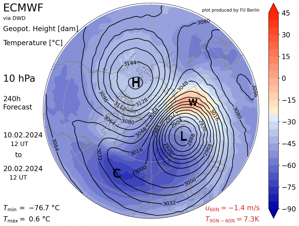
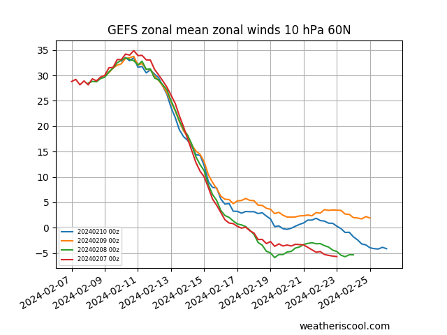
We’ve been monitoring since the start of the month the growing signal from models for zonal winds in the stratosphere, specifically at 10 hPa level at 60 degrees North to weaken considerably and likely reverse around 19th / 20th February and turn easterly for 24 hours or more – signifying a Major Sudden Stratospheric Warming (SSW). Most recent GFS/GEFS and EC46 extended model output keeps the 10 hPa zonal wind at 60N reversed or remaining very weak through to the end of the month.
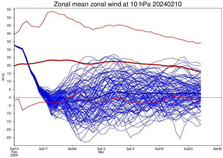
ECMWF EC46 zonal mean zonal winds at 10 hPa / 60N
There has already been a SSW back in January, when stratospheric polar vortex winds decreased to zero just after mid-month, just reaching the threshold of a major sudden stratospheric warming, but the SSW was brief and the winds turned westerly again, strengthening to their near normal state, leading to little impact on tropospheric weather patterns.
The temperature and wind anomalies associated with a SSW can descend down into the troposphere, bringing significant impacts to northern hemisphere surface weather patterns. Typically, this can eventually manifest in the tropospheric jet stream weakening, which allows cold air bottled up near the polar cap to escape and cause cold air outbreaks over much of Europe, parts of Asia, and the USA. The downward propagation of the reversal of zonal winds and warming in the stratosphere into the troposphere can take weeks or even months and impacts at the surface are not guaranteed and they are not necessarily experienced everywhere.
Source: Simon Lee / simonleewx.com - The February 2018 major SSW, the split of the polar vortex at 10 hPa which eventually lead to the Beast from the East later in the month
Every SSW is different and around 66% of them lead to colder conditions, so not all SSW events lead to cold. For example, the SSW in February 2018 led to the ‘Beast from the East’ later that month and into early March, whereas the SSW in January 2019 had no significant impact for the UK and NW Europe, due to the easterly winds in the stratosphere not propagating down into the troposphere. In fact, it stayed mild for the rest of the winter.
A Sudden Stratospheric Warming (SSW) occurs when the usual westerly flow over the arctic is disrupted by large-scale atmosphere waves (called Rossby waves) in the troposphere which get pushed higher into the atmosphere. These waves can “break” (like waves in the ocean) on top of the polar vortex and weaken it. If waves are strong enough, the winds of the polar vortex can weaken so much that they can reverse from being westerly to easterly. This leads to cold air descending and warming rapidly, with a sudden jump in temperature.
Evolution of SSW in January 2015. Image courtesy of Patrick Martineau
Although a Sudden Stratospheric Warming refers to a rapid warming (in extreme cases as much as 50°C in just a couple of days) in the polar stratosphere, between 10 km and 50 km up, a major SSW is often defined as a wintertime event in which the zonal (westerly) mean wind at 60N and 10 hPa reaches zero and turns easterly for at least 24 hours.
It’s too early to say what the impacts on the tropospheric weather patterns will be from the likely SSW in around a week’s time, given it may take a few weeks or more for the weakening winds in the stratosphere to propagate down to the troposphere – where our weather happens. Certainly the numerical weather prediction models (NWP) extended output will not have any kind of handle on impacts until at least when the actual SSW occurs and even after may take a while until they get grasps of whether there will be any impacts and, if so, what these impacts will manifest as in the weather patterns.
But if it is one of those events that does change patterns to bring colder weather, perhaps with wintry conditions, unless there is a quick response in the troposphere to the downwelling of the SSW, which doesn’t happen very often, then it is most likely the last few days of this month or more likely early March that we could see winter bite back.
A SSW can lead to a displacement or splitting of the polar vortex, so instead of cold air being locked above the polar region, it can push further south into the mid-latitudes. A split polar vortex tends to make it more likely than displacement to bring colder conditions to the UK and Europe, depending on where the polar vortex with a displacement or vortices with a split end up. The main uncertainty with these events is we don't know where exactly this cold air will end up across the Northern Hemisphere, so that's what we'll be keeping an eye out for through the rest of the month.