Today provisionally saw the warmest January temperature on record in the UK, with 19.6C in Kinlochewe in the NW Highlands. It's been rather mild this past week, but will we see colder weather return in February?
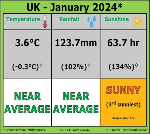
Although there was a spell of colder weather between the 5th and 20th of this month, with cold easterly then northerly winds, which brought snow in places, the rolling average temperature for this January is likely to end up close to or just above average. This is thanks to a very mild start to the month and mild weather since last weekend. Based on the Central England Temperature, January so far is 0.5C above the 1961-1990 average.
Data courtesy of Starling Roost Weather
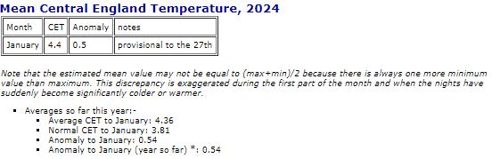
Data from Met Office Hadley Centre Central England Temperature
In fact, it’s been incredibly mild today in the north and tomorrow's turn in the south. Kinlochewe in the NW Highlands has recorded 19.6C today, making it provisionally a new UK maximum temperature record for January and a new winter record (Dec-Feb) for Scotland, thanks to the foehn effect from a strong southerly wind all the way from south of Spain warming as it descends from the Highlands. This new record beats the old one by some margin, the previous record was 18.3C set in 2003.
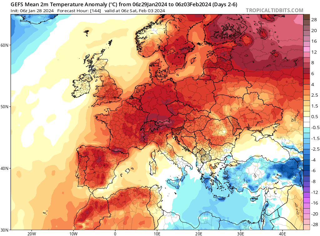
It will remain mild for most throughout the coming week too, thanks to winds from the southwest. There also looks to be very little or no rain for the next 7 days across much of southern England, Midlands and East Anglia, France and Spain too, thanks to persistent high pressure over France.
Temperatures widely above average across Europe over the coming week
So, are there any signs of colder weather returning in February? There are hints from recent teleconnection and longer-range model output for a pattern change towards mid-February that could introduce colder and more wintry weather.
Teleconnections are significant relationships or links between weather phenomena at widely separated locations on earth. Changes in the atmosphere in one place can affect weather over 1000 miles away and these changes can be used to predict weather patterns worldwide. One of these changes in the atmosphere looking to take place is over the western tropical Pacific related to the Madden Julian Oscillation (MJO) - which is the main source of intraseasonal variability in the tropics and leads to teleconnections that are felt globally.
When the MJO wave of enhanced tropical convection arrives over the western tropical Pacific it can lead to impacts to weather patterns globally. It has been established for a long time that the probability of the development of a negative North Atlantic Oscillation, which brings an increased risk of cold weather to northern Europe in winter, is significantly increased about ten days after the MJO is in phase 6-7 (enhanced convection over the Western Pacific).
The impact of the far away MJO wave in the tropics on the northern extratropical weather is due to Rossby wave propagation. The Rossby wave propagation depends on the longitude where the convection associated to an MJO event takes place. For instance, when MJO wave passes over the Maritime continent, there is usually no significant impact on northern extratropical weather patterns (e.g. over North America and Europe). However, when the MJO wave of enhanced tropical convection moves over the Indian Ocean or West Pacific, a Rossby wave is generated in the northern extratropics which can create changes in pressure patterns over North America and Europe.
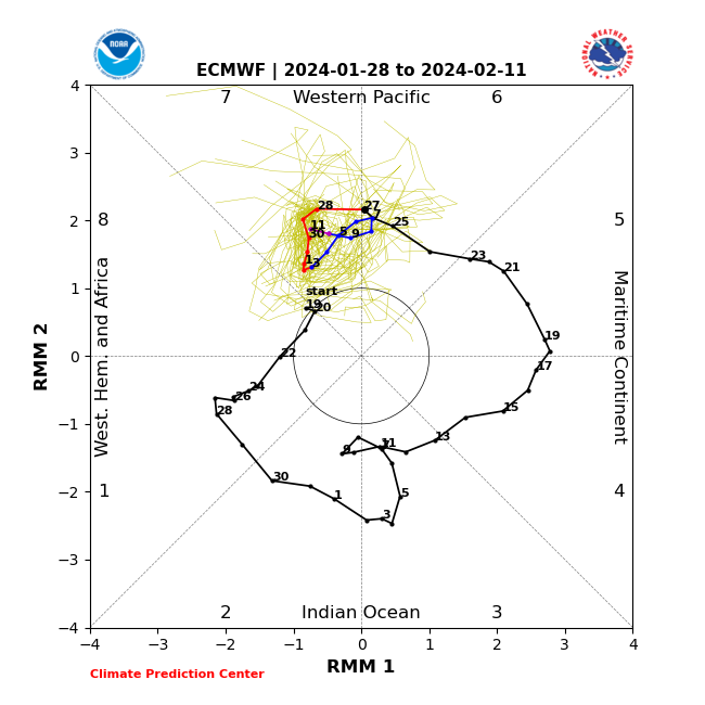
The MJO has been moving through phase 6 over the last few days and looks to be heading into phase 7 today. These two phases are over the western tropical Pacific an area of the tropics where enhanced convection can often initiate, through poleward Rossby Wave driving, high latitude blocking in the northern hemisphere, following a lag of around 10 days, give or take a few days. Tropical convection is likely to be enhanced at the moment by a deeply descending easterly Quasi-Biennal Oscillation, where winds in the tropical stratosphere are blowing easterly. This tends to lead to less stratification of the tropical atmosphere and enhances convection.
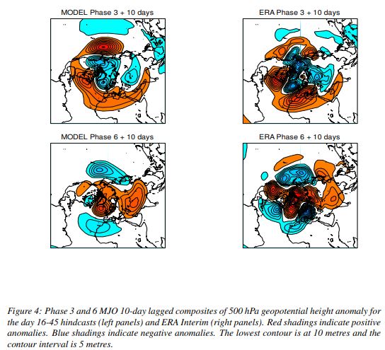
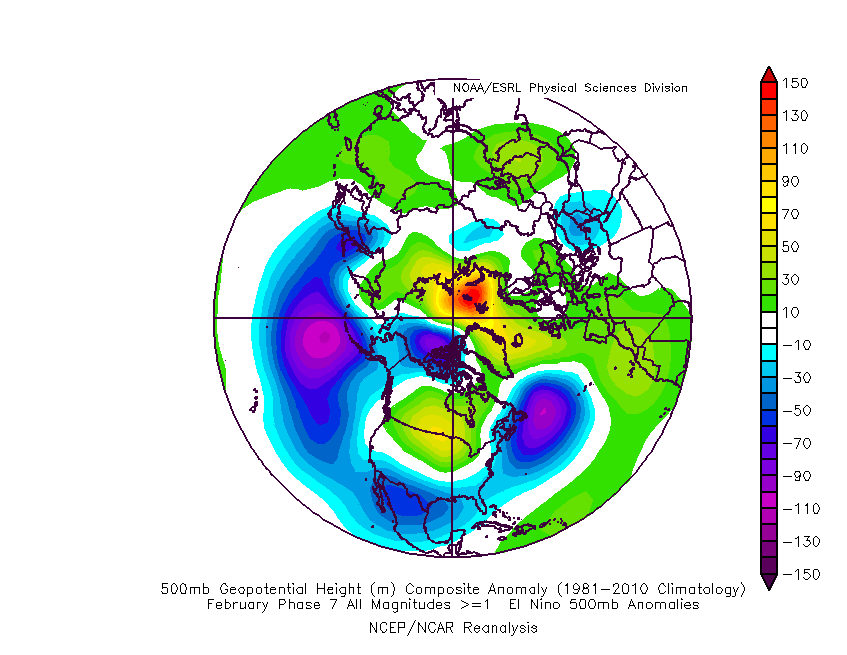
There are analog composites drawn from historical pressure or height tendencies and anomalies when the MJO is in different phases, plotted for each month. Also based on whether El Nino, neutral or La Nina. These can give a broad idea of patterns that may occur following certain MJO phases, taking into account the lag mentioned.
Towards mid-February, we may see the development of high latitude blocking in lagged response to the MJO moving through phase 7, as indicated in the analog composite 500mb patterns in phase 7 in El Nino in February below:
The extended range of GFS ensembles (GEFS) now beginning to suggest a fall in temperature into the second week of February.
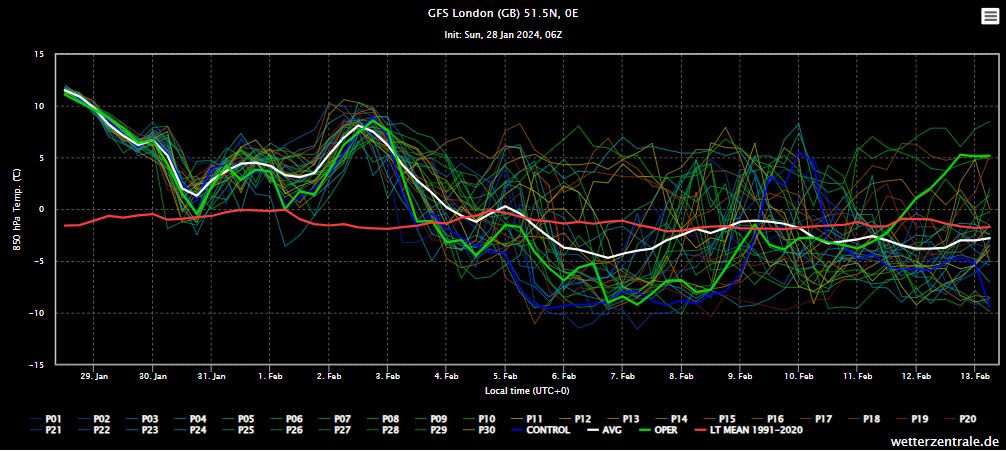
When colder conditions will arrive and where they will come from is too early to say for now, but perhaps sometime through the second week of February, though perhaps not until mid-month. Despite the recent mild weather, there’s plenty of time for winter to bite back, even in March or April, though after February, any snow that settles tends not to hang around unless the airmass is unusually cold.