A potential northerly outbreak brings the chance of wintry showers and frost this time next week. In the meantime, there's more rain in the picture this weekend.
Recent medium-range forecast models have indicated the possibility of a northerly outbreak occurring in about a week, which could bring wintry showers and night frosts. While most model runs do not predict temperatures cold enough for snow accumulation at lower levels, except briefly in northeast Scotland, the most likely scenario involves snow showers primarily on higher ground in the north. Lowland areas near north-facing coasts, especially in counties along the North Sea, may experience rain showers and possibly some sleet.
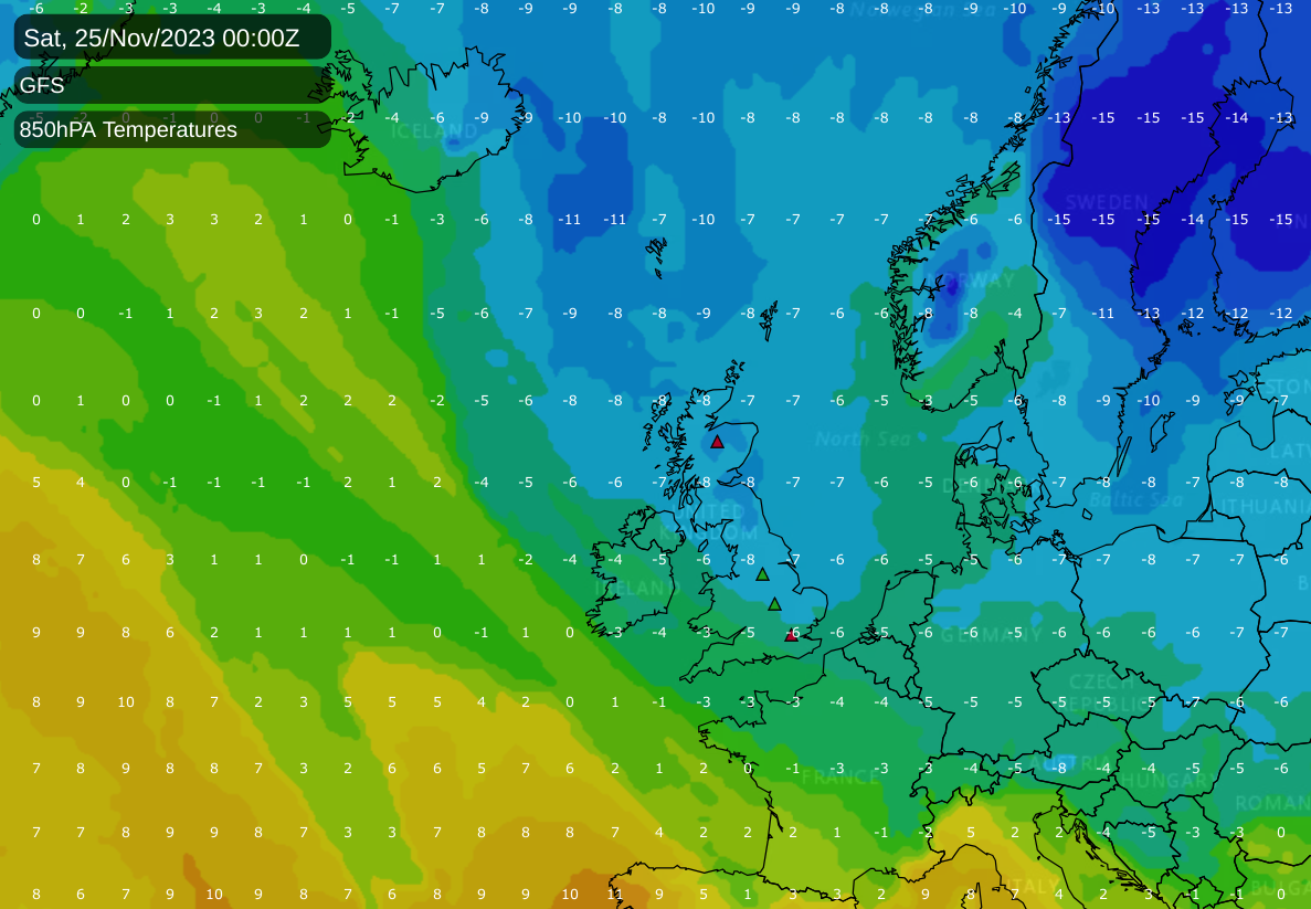
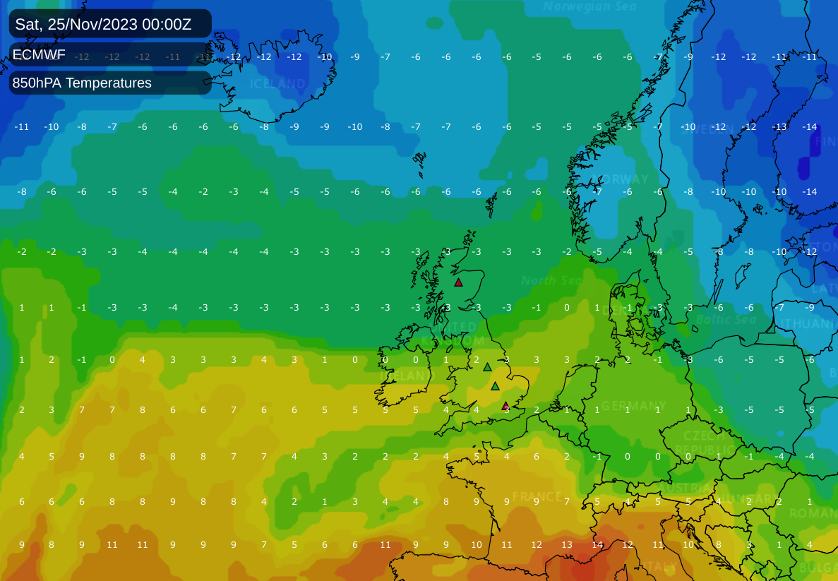
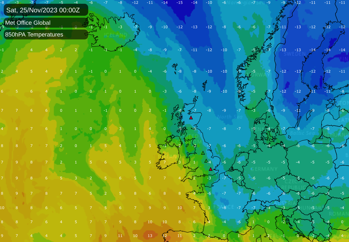
The likelihood of the British Isles being impacted by this northerly outbreak remains uncertain. At the time of writing, the GFS model strongly supports the idea of the British Isles being directly hit. Conversely, the UKMO model suggests that the impact will be limited to the eastern part of the country, while the ECMWF model mainly predicts the system moving into the North Sea.
Regardless of the impact from the northerly, the weather is expected to become drier for most regions. High pressure is anticipated to build southwest of Britain towards the end of November and shift to the south or southeast in early December. This should alleviate the ongoing flooding issues, with the exception of northwest Scotland, which has recently experienced less rainfall than usual due to low pressure systems tracking further south.
During the 1980s, 1990s, and 2000s, November snowfalls at low levels were fairly common across the UK, despite the overall warming climate trend. However, snow generally tended to be short-lived away from the northern highlands. Most November snow events were caused by northerly outbreaks, although "easterly" snowfalls also occurred when cold snaps in near-Continent Europe brought cold air to Britain from the east.
The most widespread November snowfalls in the 1990s occurred between November 20-22, 1993, and November 19-24, 1996. In 1993, snow persisted for about a week at low levels in parts of eastern Scotland and northeast England. On November 17, 1995, parts of these regions saw snow reaching nearly sea level.
The 2000s featured several significant snow events, including early snowfalls from a northerly on November 8/9, 2001, frontal snow in northern England and the Midlands on November 18, 2004, heavy snow in Cornwall and Devon on November 25, 2005, and widespread snow in eastern England on November 22/23, 2008.
The most memorable recent November wintry spell occurred in the last week of November 2010. During this time, northerly winds and troughs brought widespread snow, especially in northern and eastern Britain, from November 25-28. Southern regions experienced snow as well on November 29 and 30, accompanied by exceptionally low temperatures and sharp night frosts.
However, since 2010, November northerlies have generally not been cold enough for significant snowfall at low elevations, even in Scotland's northeast. The most notable lowland snow events occurred on November 30, 2017, and November 26-28, 2021, along with a brief snowfall in some eastern counties on November 20-21, 2015. These events, however, did not produce snow cover as widespread as those in the 1990s and 2000s. It seems unlikely that November 2023 will deviate from this trend.
The forecast for today includes the clearing of persistent rain from most UK regions, except for western Scotland, which will remain wet. Eastern Scotland may see some sunshine, but England and Wales will generally be overcast, with only occasional sunny intervals. Brighter, showery weather is expected to reach Northern Ireland, Wales, and the West Country. Temperatures in northern Scotland will be around the seasonal average of 7 to 9°C, while southern England will be warmer, reaching highs of 15 to 16°C. Windy conditions are expected, particularly along south and west-facing coasts and hills.
Sunday is predicted to be mostly cloudy with showers, although some sunny spells are possible to the east of high ground. Showers in the west may converge into persistent rain. Temperatures will again be mild.
From Monday and Tuesday, high pressure moving near the southwest is expected to bring drier and calmer weather to most regions, with variable cloud cover and temperatures near the seasonal norm. Looking towards next Friday, there is a potential for a northerly outbreak, but as previously mentioned, any resulting snowfalls are likely to be confined to higher ground in the north.