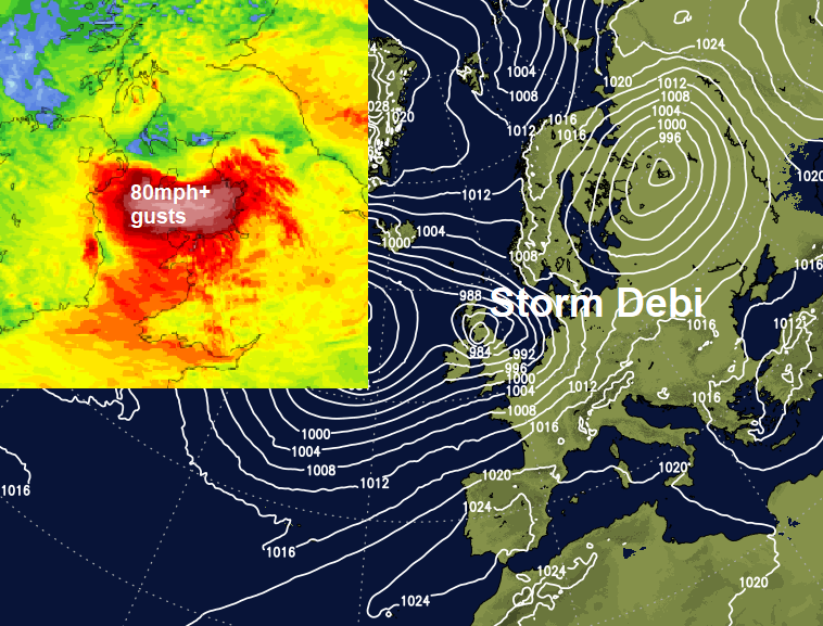
The weather will be relatively benign for Remembrance Sunday. However, a deepening low named Storm Debi will arrive across Ireland tonight before moving across N England Monday, bringing severe gales for Irish Sea coasts and N England.
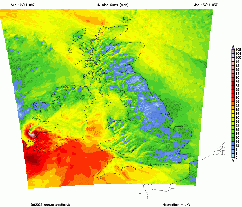
Storm Debi has been named by the Met Office this morning, for a deepening low that will move northeast across Ireland then northern England on Monday. Strong westerly winds are forecast to develop across the Irish Sea , northern and western Wales and northern England on the southern flank of the low during Monday morning and into the afternoon. Gusts of 60-65mph possible inland across these areas, while Irish Sea coasts and over higher ground in these areas, such as the Pennines, could see 70-80mph gusts. A spell of squally and locally heavy rain will also sweep north and east across most areas through the morning, followed by sunny spells and showers.
However, Remembrance Sunday will be the relative calm before the storm for many. Winds will be generally calm this morning at least, which is leading to a foggy and also frosty start in the north, Southern, central and western areas are cloudier with some rain moving northeast.
It was a cold and foggy start to Remembrance Sunday for many northern and eastern areas, temperatures under clear skies fell as low as -4.6C at Loch Glascanoch in the northern Highlands. But in contrast it's been a grey and damp morning for southern, central and western areas for Remembrance Day parades. A swathe of rain will continue to spread northeast across N. Ireland, England and Wales this afternoon, reaching NE England and southern Scotland.
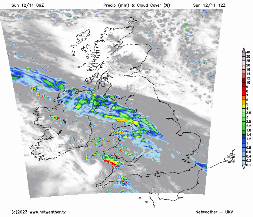
The rain will be followed by brightening skies from the southwest across Wales, southern and central parts of England this afternoon, but also some sharp showers will also move northeast across southern parts of England and Wales. Northern England and southern Scotland may stay dull and damp with outbreaks of rain until dark, but northern Scotland should have a fine, sunny but chilly day. Temperatures reaching 7-9C across Scotland and NE England, while across rest of England, Wales and N. Ireland they will reach 9-13C, perhaps 15C in the far southwest.
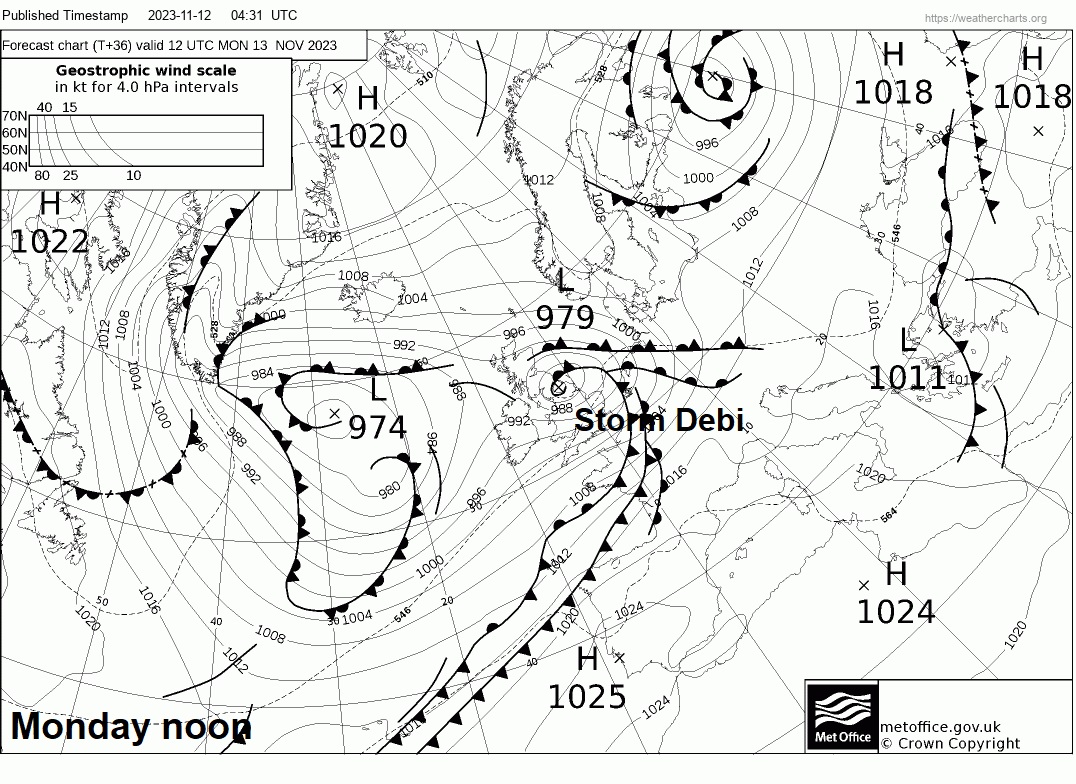
A developing low moves northeast across Ireland tonight, so winds will strengthen from the south and southwest initially overnight, with gales developing over Ireland, Irish Sea and western coastal areas – while outbreaks of heavy and squally rain looks to sweep northeast across N. Ireland, England and Wales overnight, reaching southern Scotland before dawn. Chilly across northern Scotland overnight, perhaps a frost in sheltered Glens, but otherwise a milder night further south as winds pick up, with temperatures in double figures as the rain moves in.
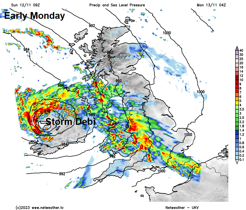
Potential for some disruption for the morning commute and travel generally Monday morning across Ireland, Isle of Man and Irish Sea coastal areas of Wales and NW England – as Storm Debi moves northeast over Ireland then over the Irish Sea towards northern England. Winds could gusts between 60-70mph, perhaps locally 70-80mph on exposed coasts and over hills of coastal areas surrounding the Irish Sea. These strong westerly winds transferring east across northern England into the afternoon, as the Storm Debi deep depression tracks northeast across the far north of England. Gusts of 60-65mph could develop inland across northern England, perhaps higher gusts over high ground of the Pennines.
Windy generally across England and Wales further south, with gales possible around coasts. Outbreaks of rain pushing north and east across the UK overnight will clear north and east from most of England and Wales during the morning to sunny spells and a few blustery showers around western coasts. However, it looks to remain wet and windy across the far north of England and much of Scotland into the afternoon. Could be 20-30mm in places, which could lead to some localised flooding. Temperatures reaching 9-10C across Scotland, 11-15C across England and Wales.
The Storm Debi low moves on east towards Denmark then the Baltic Sea on Tuesday, with another area of low pressure moving into the west of Scotland before crossing Scotland on Wednesday. So northern areas both Tuesday and Wednesday will be windy with spells of rain or showers, drier and sunnier over England and Wales, some showers too, but mostly towards western coastal areas.
Some uncertainty Thursday with regards to a deep area of low pressure over the North Atlantic modelled to approach NW Europe, GFS tracks a deep low east across Ireland and central areas of Britain, ECMWF tracks the low east over northern France. So it could be wet and windy across many areas or just the south or far south or not at all – with just showers around coasts. Friday most likely bright and breezy with showers towards western coasts, but may turn wet and windy in the southwest in the evening.