Following hot on the heels of Storm Ciaran, another storm brewing over the Atlantic has been named by the Spanish Met Service Domingos. This storm will bring gusts of up to 80mph and large waves to Atlantic coasts of France and Spain. Here it will bring another 30-40mm of rain in the south.
After a day’s respite to recover on Friday, following the destructive winds from powerful storm Ciarán yesterday across northwest France, Channel Islands and far south of England, a new high-impact storm is brewing out over the North Atlantic and will target areas further south across western France and the north coast of Spain over the weekend. The new storm has been named Borrasca Domingos (Storm Sundays) by the Spanish State Meteorological Agency (AEMET) and is forecast to bring wind gusts of up to 80mph across the Atlantic coast of France.
Watch Storm Domingos low move from the NW Atlantic to southern England Saturday night, bringing strong winds to western France
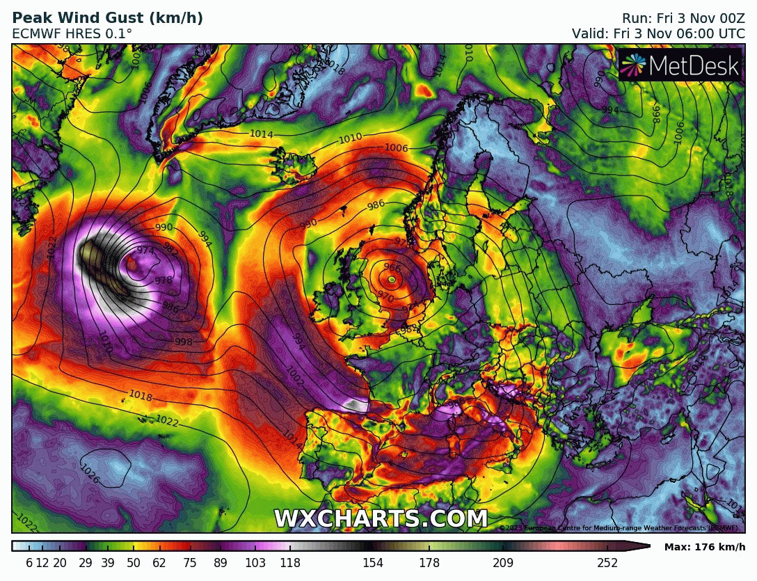
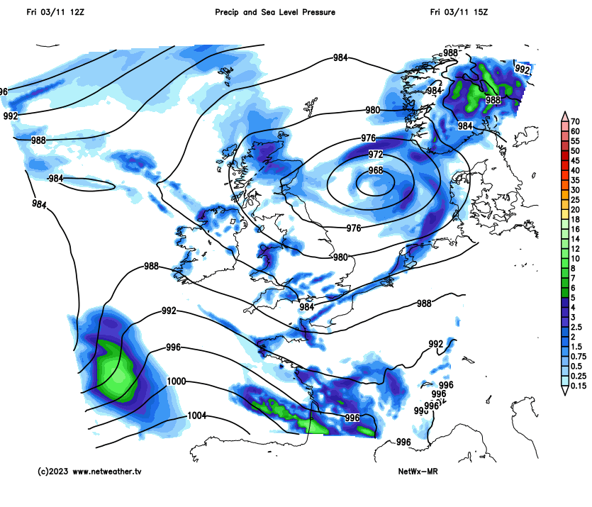
The centre of the deep low named Storm Domingos will actually track east through the English Channel or south coast late on Saturday evening, not much further south than Ciaran yesterday, however, the strong wind field will be much wider to the south of the low centre, with strongest winds from the west covering much of the Bay of Biscay and into the west of France and the far northwest and along the north coast of Spain.
The rain from Storm Domingo will be of more concern than the wind for parts of England and Wales over the weekend, though there could be gales through the English Channel – hampering the clean up on Jersey and northern France, following Storm Ciaran’s damaging winds.
It’s been a much quieter day today, with sunny spells and lighter winds, however, there’s still been some showers around across the south, the west and far northeast. The showers should fade to leave a mostly dry and chilly night for Scotland, northern and eastern England.
More rain followed by heavy showers on the way tonight and through Saturday
However, after a dry first half to the night, a band of rain, locally heavy, will spread in across Wales and southern England in the early hours. This rain band gradually clearing north and east across England through the day on Saturday, though may linger over NE England. The rain band followed by sunny spells but also heavy and thundery showers towards southern coastal area of England and Wales, areas well inland could stay mostly dry and sunny. Scotland and N. Ireland look to have a mostly dry day, though a few coastal showers are possible. Gales possible through the English Channel – with 40-50mph gusts possible along the south coast and Channel Islands. Temperatures reaching 9-13C.
Forecast Rainfall accumulations for Saturday
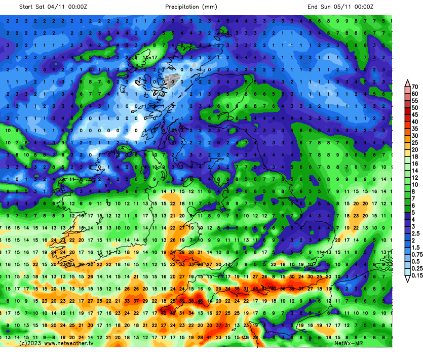
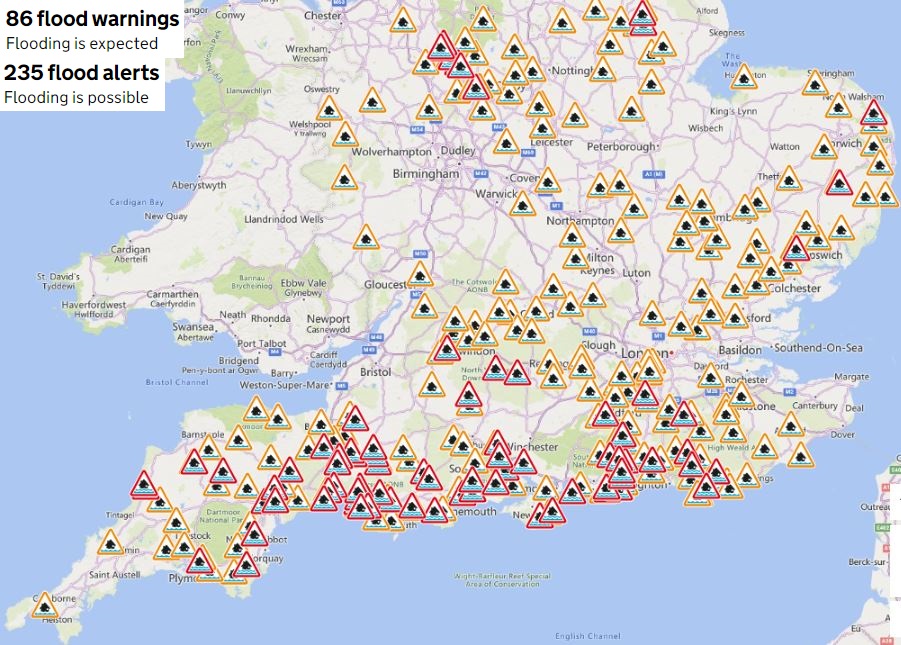
The heavy rain band moving northeast and heavy showers following across southern counties of England could bring over 20mm widely or 30-40mm in places on Saturday. This falling on already saturated ground following a very wet October and wet start to November will further exacerbate already high river levels in places, leading to further flood warnings likely being issued – with a risk of flooding to property. Also, lots of surface water around and river flooding could lead to roads being blocked.
Lots of Flood Warnings in force for the south earlier today
Sunday fortunately is looking a drier day, as winds turn westerly to northwesterly, though there will be some showers along western coastal areas and the Cheshire Gap exposed to the wind. Eastern areas of Britain look to stay mostly dry and sunny though. Windy for many though and feeling cool in that wind. Temperatures reaching 10-13C.
The west of France looks to bare the brunt of the strongest winds from Storm Domingo this weekend, particularly Saturday evening, with 75-80mph gusts possible along the Atlantic coast, 50-60mph gusts possible further inland across the west.
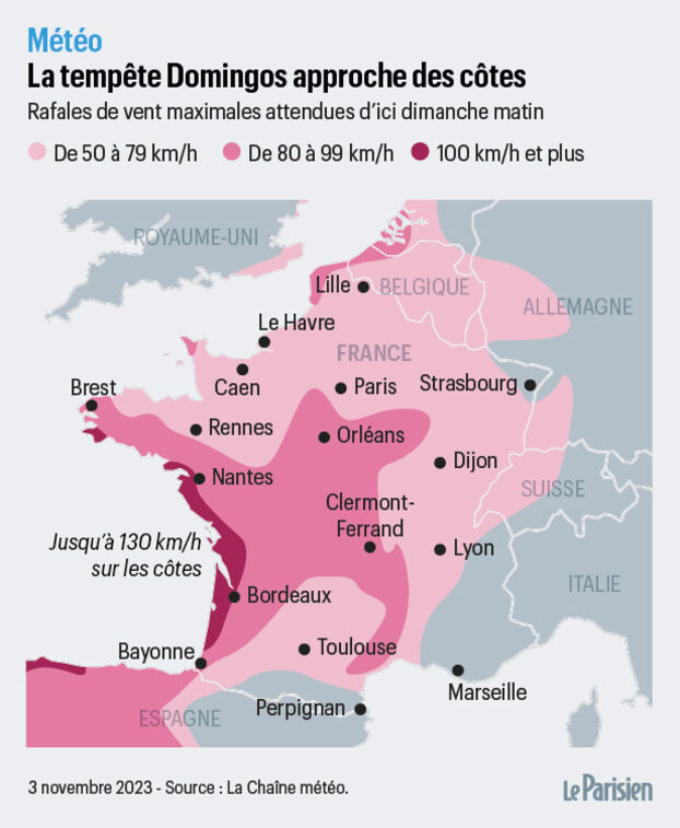
130 km/h = 80mph
40-50mph gusts are forecast widely across the northwest and north coast of Spain, however along exposed coasts and mountains in the north, there could be gusts over 60mph.
The very low central pressure of Domingos, dropping to 959 hPa as it approaches SW England, will also generate a strong rise in sea level or a surge, particularly on Saturday evening. Very high waves from the Bay of Biscay look affect the coastlines from Charente-Maritime in France south along the French Atlantic coast and west along the north coast of Spain in the evening. Wave heights may reach or exceed 7 or 8 meters along these Atlantic coasts. The combination of these strong waves and the strong surge could cause coastal flooding.
Then on Sunday, the strong winds will move towards the Mediterranean, with gusts of 40-50mph across NE Spain and the Balearic Islands. Strong southwesterly winds will generate large waves from Saturday night into Sunday across the western to central Mediterranean – which could lead to coastal flooding over the Balearics, Mediterranean coasts of France, Corsica and Sardinia.
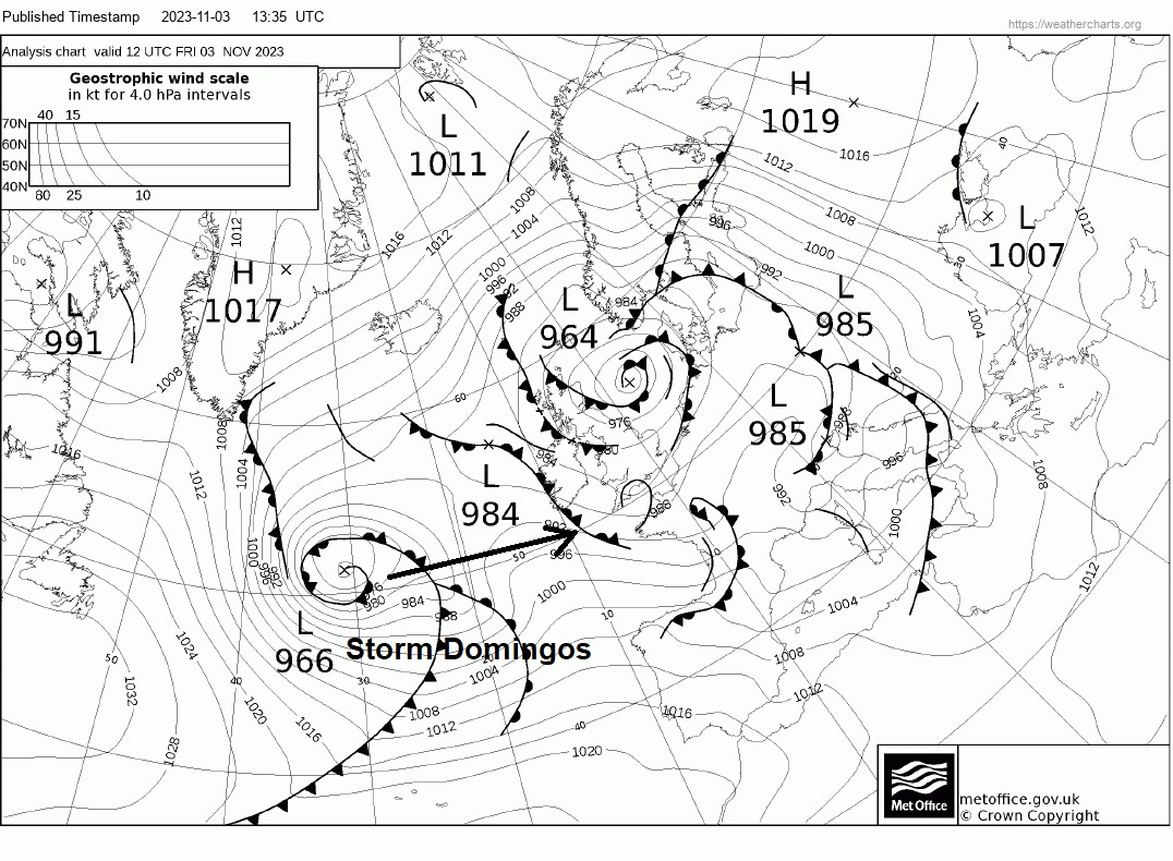
Unlike Storm Ciarán, the Domingos low is already well-formed today over the North Atlantic Ocean and will not undergo “explosive deepening” like was the case for Ciaran – which was still deepening as it crossed southern England yesterday. Domingos low will reach its stage of maturity on Saturday morning as the centre passed close to the south of Ireland and not East Anglia, as was the case for Ciarán.