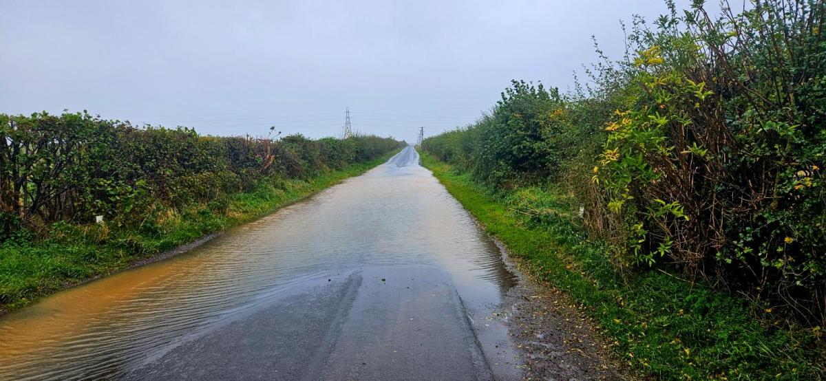
There is still plenty of water around and flood warnings in place with more rain and showers on the way this weekend. Travel disruption continues, as does the rain.
We have a large Atlantic low pressure anchored out west for the next few days and a smaller deepening low centre nipping up from the Bay of Biscay across southern Britain later on Saturday. All of this means more rain or showers falling on sodden ground and, at times, some blustery or windy weather.
For flood-hit areas, it brings tension and strain after already shocking events. Eastern Scotland, Yorkshire, the East Midlands in Storm Babet, and the Isle of Wight saw torrential rain and disruptive flooding midweek from more southern showery rain. There is major disruption on the Island line and many train services have been cancelled from Edinburgh to Inverness or Aberdeen.
It's not all rain for this weekend, some parts will see bright weather with temperatures around 10 to 15C but the rain is giving concerns.
At this time of year, there is still some warmth in the sea. Those who sea swim will know that having a dip in October is much less bracing than in March/April time. There is a lag compared to the change in air temperature around the UK, although it has been a mild October. This cyclonic setup has low pressures from the west or southwest and plenty of showers feeding in. These will continue to be lively with the risk of slow-moving heavy downpours in the unstable setup.
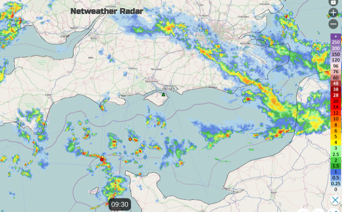
Netweather Radar showing showery rain progressing eastwards from the English Channel on Friday morning with a few lightning strikes
The next few days might prove frustrating if you are watching weather app symbols and time slots for a drier weather window to pop out. It is hard for the models to get that detail right in this kind of setup. On the day you can watch the radar and see what is coming, use the animation button to see how the showers or rainbands are moving.
The easterly flow continues off the North Sea but it has stopped raining for NE and eastern England after a wet time on Thursday. Eastern Scotland already saw plenty of wet weather on Thursday, seemingly for most of the day in the southeast and the concerns continue.
Eastern Scotland has a yellow warning for rain from the Met Office for three more days and the linked SEPA yellow flood warning
“Significant flooding impacts from rivers and surface water on Thursday, Friday and Saturday are likely in the northeast. There is also a risk of further impacts in areas recovering from recent flooding. River levels are not expected to be as high as experienced during Storm Babet but as the rain will be falling onto already wet ground, flooding from surface water runoff may also cause impacts...” SEPA”
Outbreaks of showery rain continue to feed across Scotland from the east during Friday with heavier bands edging into SE Scotland and then across the Forth to the Tay on Saturday morning. Then potentially heavier rain develops on Sunday for eastern Scotland into the night and on Monday.
Again there will be lee gusts for the high ground of western Scotland today and moreso on Saturday with a fresh to strong easterly flow. For Saturday night and Sunday exposed coasts and hills of northern Scotland could see easterly (backing NE) gales with widespread high gusts. For the coast of Angus and eastern Aberdeenshire, it might be worth keeping an eye on the winds for Sunday evening, ferries to the Northern Isles could be ‘autumnal’.
Although the October half-term holidays seem to vary around the country there will still be people on the move, travelling to different parts of the UK. Pack your wellies and remember, for flood waters, just turn around. Don’t take a chance just because someone else did. Assume that the water IS deeper than it looks and in muddy waters you can not see what condition the road is in. There are already some rail line closures, road diversions and saturated ground with a lot of surface water.

The same conditions continue for central and eastern England with high river levels and flooded fields. Here with lighter winds, there has been fog. Again this morning there was a Met Office fog warning with poor visibility. As all this moisture lingers with the calm conditions, fog will form again overnight ready for Saturday morning.
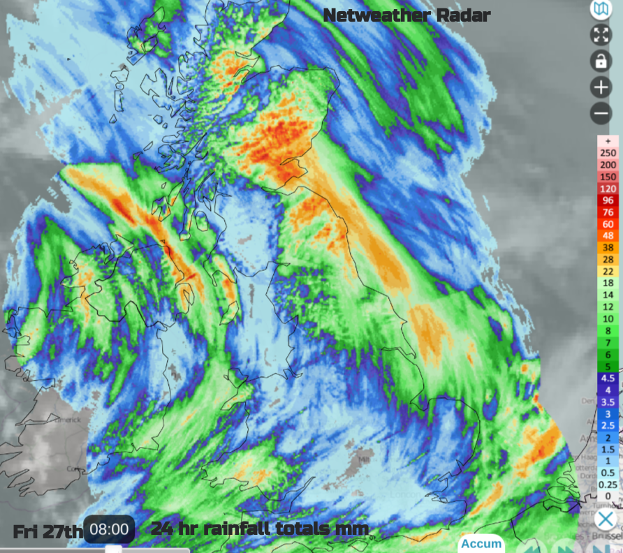
"River levels remain high following rainfall associated with Storm Babet, and are expected to remain high throughout Friday 27th of October with further rain forecast. Please avoid using low lying footpaths near local watercourses and plan driving routes to avoid low lying roads near rivers, which may be flooded." Env. Agency
There will be clusters of showers over central Britain on Friday, although with a lot of fair, bright weather. Northern Ireland seems to be a focus of heavy showers, from the southeast but drifting to the northeast later. Bands will move northwards tomorrow.

Already on Friday morning, there have been bands of heavy rain working their way eastwards. Lightning strikes have reached Guernsey and there will be further clusters today however things look set to pepp up tonight and tomorrow. Heavy showers will reach southern Wales and move across southern counties of England. All of this will add to the wet conditions and affect sports pitches for Saturday morning.
As the smaller low centre arrives from the southwest on Saturday afternoon, there will be pulses of squally weather with strong gusts along with heavier rain. These downpours should move through. It is the lingering rainbands or persistent feeds that cause the biggest issues. When the rain just keeps on coming from the same direction. As long as this small low nips through it should push the heavy showers along with it. However, there is another yellow rain warning over southern and southeastern England for all of Saturday and Saturday night as the heavier rain moves through.

Local flooding is likely, there is already a lot of water about and as the Isle of Wight saw by Wednesday morning conditions can deteriorate far too quickly. It is worth doing some preparation this autumn and today and do sign up for the postcode-focused flood warning service from the various Environment Agencies.
"Avoid contact with, walking or driving through flood water."
Don't be surprised if the weather warnings are extended, in time and/or area over the weekend. There will be significant rain for eastern counties of Northern Ireland, southern Wales, central southern England and the Isle of Wight across to Kent. The frontal rain from the smaller low during Saturday afternoon and evening needs watching for the southern half of Britain, starting from the southwest but reaching The Wash. Also eastern, central and northeast Scotland through the weekend with the Central Belt and northern part of the A1 looking vulnerable on Sunday.