Monday saw another unusually warm day for early October across southern Britain which felt more like a warm summer’s day than the middle of autumn. Monday’s highest temperature reached 26.1C at East Malling in Kent, some 10C above average. Monday was the third day in a row where the temperature has reached over 25C in the UK. October is normally cooler than this, but we may see 25C+ for the 4th day in a row today across SE England.
Further north, a set of fronts will move southeast across Scotland and N. Ireland today, bringing a return of cloud and rain to northern areas. These fronts then look set to move down across England and Wales tonight, bringing quite a change tomorrow across Wales and central parts of England, though some warm sunshine possible across far south of England before rain arrives in the evening. Sunshine and showers following further north. Cloud and a few spots of rain may linger in the far south Thursday, otherwise for most a fine day and feeling fresher. More persistent rain moves in from the southwest across southern Britain later on Thursday and looks to linger across England and Wales through Friday,
Brighter and showery in the north on Friday and turning cooler as winds turn northerly here, these cool and fresh northerly winds spreading south across all parts over the weekend, dry and bright for many, but showers likely around northern, western and eastern coastal areas of northern Britain. Clear skies at night could also lead to the first widespread frost risk of the autumn too.
For now, more unwelcome heavy and persistent rain has moved in across western Scotland overnight – where there is a Met Office yellow rain in force. There is also 2 Severe Flood Warnings and 33 Flood Warnings in force.

A further 50mm could fall before the rain clears later today. So, a cloudy and windy day with outbreaks of rain spreading east across Scotland and N. Ireland before reaching NW England this evening. Rain not as heavy or persistent than the west across eastern Scotland and NE England.
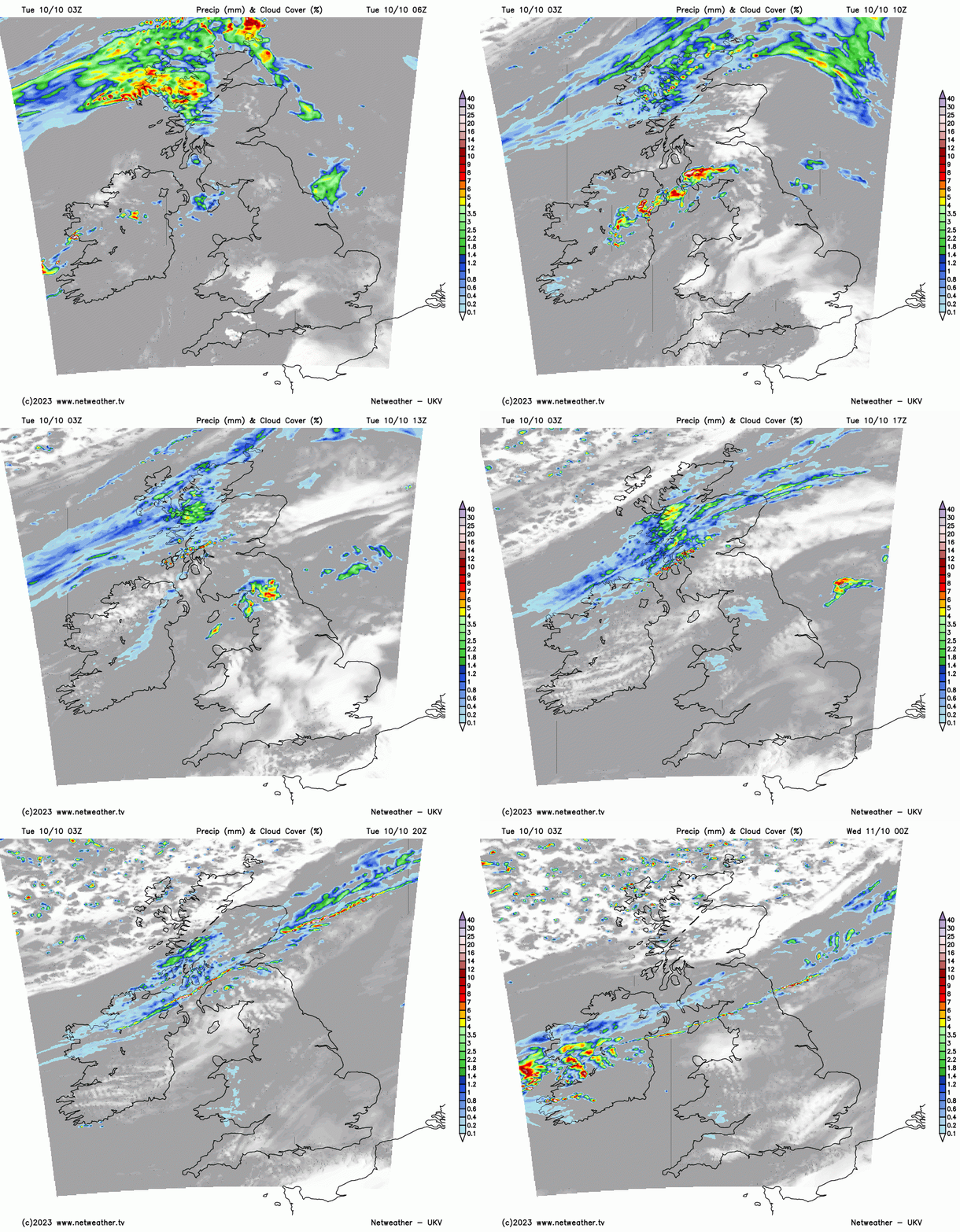
Further south, the warmth goes on, after a cloudy, misty and murky start in places, some warm sunshine developing across east Wales, central, southern and eastern areas of England. Remaining grey and murky around southern and western coastal areas of Wales. Unseasonably warm in the sunshine, reaching 20-24C, perhaps in a few spots reaching 25C in SE England.
Band of rain moving southeast from Scotland down into northern England and also Wales – where it will turn heavy and persistent by dawn. Clearer spells following across Scotland, but also some blustery showers across northern and northwestern coastal areas. Fine and dry across southern England and East Anglia, though some fog patches may form in places.
A band of cloud and outbreaks of rain, locally heavy, will affect Wales, southern N England, Midlands across to Norfolk through much of the day before eventually slipping down across southern England during the evening – where there could be some warm sunny spells beforehand. Brisk northwesterly wind and sunny spells across Scotland, N. Ireland and northern half of N England, but also some blustery showers for NW Scotland. Temperatures perhaps reaching 20-21C across the far south of England, low to mid-teens further north.
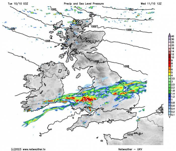
Remaining rather grey across southern England and south Wales on Thursday, with the odd spot of rain or drizzle, before more organised outbreaks of rain push in from the southwest through the evening, turning heavy in the southwest. Otherwise, further north, a mostly fine day with sunny spells, though some showers likely across NW Scotland.
Friday is looking a rather cloudy and wet day across England and Wales, as outbreaks of rain spread northeast with an area of low pressure, heavy and persistent in places. Scotland cool, bright and breezy – with the brisk northwesterly wind bringing heavy showers to western Scotland.
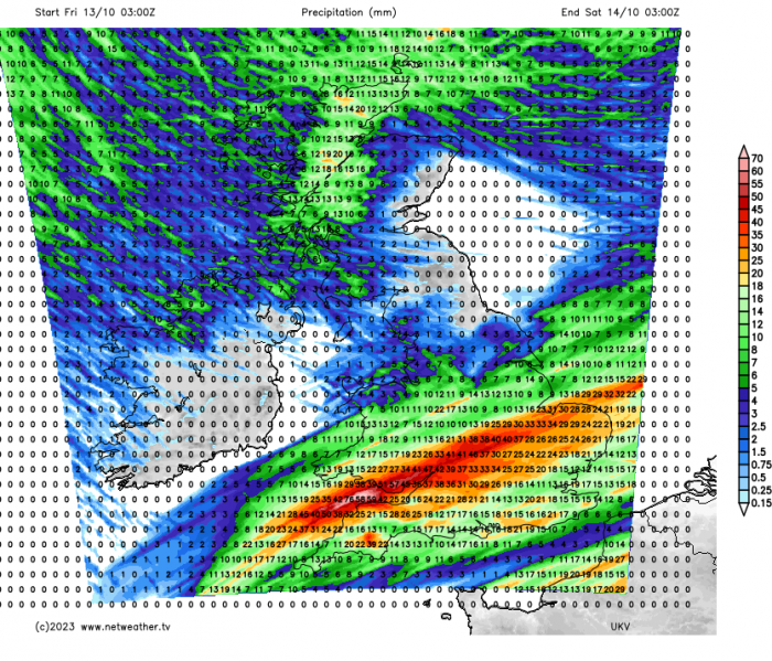
A dry weekend for most, but with a brisk north or northwesterly wind across all parts making it feel much cooler than of late across southern Britain. It won’t be dry everywhere, with showers affecting northern coasts of N. Ireland, northern and western coastal areas of Scotland and Irish Sea coasts of NW England and Wales. Temperatures reaching the low to mid-teens at best in the south, high single digits to low teens across the north. Risk of a ground frost overnight in sheltered areas in the south, air frost in the north. Quite a change from summer-like weather in the south to more autumnal weather.
Loading recent activity...