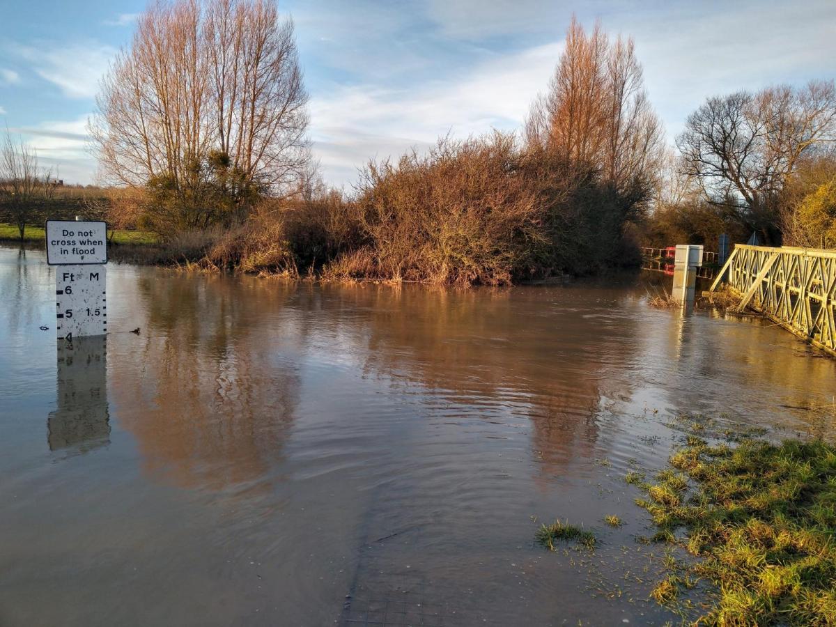
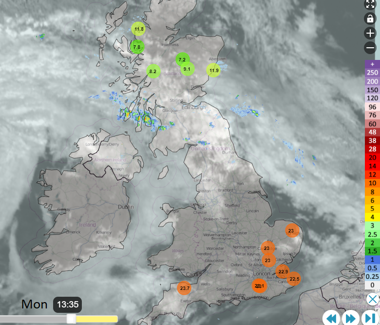
That was quite a weekend! Sunshine and bizarre October warmth for many parts of the UK with London passing 25C on both days. Temperatures reached 25.8C on Sunday at Kew Gardens, 25.5C was the top temperature in Suffolk, Cardiff reached 24.4C and 22.5C for County Fermanagh. This contrasted with soaking wet Scotland which was covered in weather and flood warnings, with landslips, closed rail lines and major routes, and cancellations all over the place.
Glasgow saw 74mm (around 3”) of rain over the weekend, Edinburgh 52mm. Many gauges in central Scotland recorded 100mm with Argyll’s A83 seeing 170mm in an area known for landslides. This was were 10 people had to be airlifted from their cars by the coastguard rescue helicopter on Saturday. One SEPA gauge on the west coast near Loch Melfort recorded 184mm of rain over the weekend with 3” of rain falling on Saturday morning. 87mm was recorded in the Lake District.
So, weekend reflections will be very different depending on what you experienced. You may be thinking, how long is this weird warmth going to last? Or will I ever see the sun again?
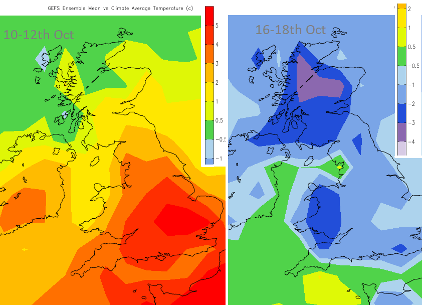
There are some concerns around Tuesday’s rainfall for western Scotland but the forecast does look drier and brighter beyond that, although cooler and with even a few wintry bits showing later this week in the far north.
The unusually warm air remains over all but the far north of Scotland on Monday with temperatures into the 20s Celsius once more on a calm day. It will be mild across mainland Scotland tonight in a south-westerly breeze. The warmth will be over much of Britain on Tuesday before cooler air slides in from the northwest behind the frontal rain. It will be blustery for Northern Ireland, around the Irish Sea and for northern Britain by Tuesday afternoon.
Tuesday night looks colder, certainly feeling that way in the wind with westerly gales and rough seas for Orkney and Western Isles. Further south the warm air holds on but the cooler air will push southwards in the middle of the week and Wednesday night looks cooler for much of the UK, just the far southwest escaping.
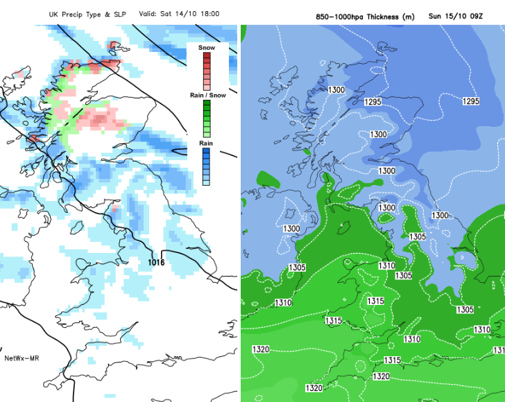
There are signs that on Friday the warmer air could surge back over more of southern Britain but there is some uncertainty that far ahead as it depends on a waving front. There is some very warm air showing over northern France on the charts for Friday. The weekend thickness charts show colder air spreading right down through the UK with sleet or hail showers in the far north and snow for the mountain tops. Quite a change.
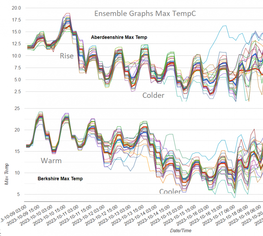
Looking at the ensemble member graphs, there is a very strong trend on the northern Scotland graph, Aberdeenshire shows a rise on Sunday and then a progressive cooling. For the southern England choice, Berkshire, the warmth remains for the next day or so but then the lines of the different ensemble members aren’t quite as close together, not such a strong signal. This shows different possible solutions Thursday and Friday although the overall trend is about cooling off.
The weekend rain was from a stagnating weather front between two low pressures, one to the west over the Atlantic and one to the east over the Baltic Sea. We still have the colder air to the north and the warm air to the south but a small low centre along the frontal boundary disrupted the steady pattern to end the weekend. The Atlantic low pressure is still in place, feeding up a few weather fronts and enabling the flow of warm air from western Europe.
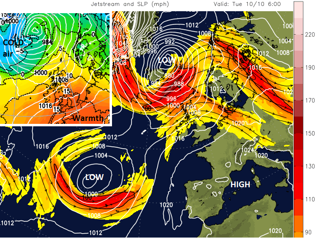
Fragmented jetstream with cut off low in the Atlantic and a stronger jet core to the north with deep lows for Iceland
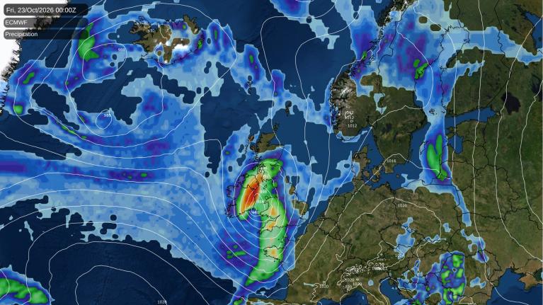
A new low will deepen rapidly near Iceland. There are warnings there for intense rainfall with the risk of landslides, severe gales and mountain snow by Tuesday. The cold front from this active system will reach down to western Scotland and bring more heavy rain.
“This may bring further impacts from flooding, including the disruption of travel, given the recent wet conditions.” MO
The wild weather over Iceland will brush past the far north of Scotland Tuesday night into Wednesday and be followed by another small but vigorous low on Thursday. Both of these help to pull down colder air from the north.
Meanwhile the frontal boundary between the two airmasses over the UK, and the line of rain, hangs around over Wales and England.
We could look at the deterministic solution which shows one picture of where the frontal rain will be Thursday and Friday, the most likely solution. Or we can consider the ensemble set of solutions and a more probabilistic view.
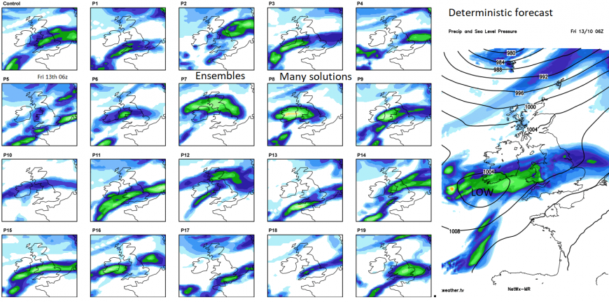
You can see on the postage stamps, how varied the ensemble solutions are, with the main threat of rain reaching into Scotland again or not as heavy. The deterministic solution is shown as well, but we need to keep in mind how things may change whilst also planning and preparing for some potentially very wet weather.
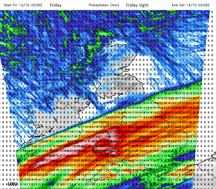
Western Wales looks wet, then perhaps Southwest England, but the rainfall chart for Friday and Friday night shows very heavy rain and high totals. It’s tricky for any early warnings, as there is quite a large area that could be affected.
SEPA Severe Flood warning Aviemore "River levels have now peaked but were higher than those experienced in early December 2015 and are now forecast to slowly fall during Monday. Stay away from flood water and do not take unnecessary risks" and Perth "The River Tay remains high in the area, and is expected to fall slowly during Monday. Further rain showers in parts of the Tay catchment on Monday night into Tuesday, may result in the River Tay rising slightly again. The Perth Flood Prevention Scheme will remain activated."
The more immediate concerns are for flood-hit areas of western and central Scotland as more rain arrives on Tuesday. Recovery clear-ups are underway and they could do with a bit more of a lull.
Next rain, from possibly early Wednesday, for Wales and affecting more of southern Britain by day with a risk of impactful rain Thursday night from the southwest, into Wales and England on Friday before clearing from the southeast on Friday night. The uncertainty around the positioning of the frontal band will make issuing any warnings quite tricky for the Met Office at this point.
Loading recent activity...